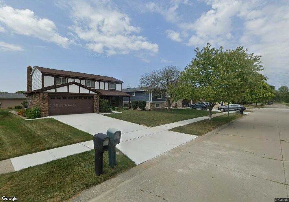
451 N Corrine Blvd Canton, MI 48187
Estimated Value: $362,000 - $451,000
Studio
3
Baths
2,159
Sq Ft
$184/Sq Ft
Est. Value
About This Home
This home is located at 451 N Corrine Blvd, Canton, MI 48187 and is currently estimated at $398,177, approximately $184 per square foot. 451 N Corrine Blvd is a home located in Wayne County with nearby schools including Canton High School, Discovery Middle School, and Salem High School.
Ownership History
Date
Name
Owned For
Owner Type
Purchase Details
Closed on
Nov 28, 2005
Sold by
Phayakalas Anant and Phayakalas Corazon V
Bought by
Phayakalas Jim
Current Estimated Value
Home Financials for this Owner
Home Financials are based on the most recent Mortgage that was taken out on this home.
Original Mortgage
$203,200
Outstanding Balance
$114,164
Interest Rate
6.36%
Mortgage Type
Fannie Mae Freddie Mac
Estimated Equity
$284,013
Purchase Details
Closed on
Aug 2, 2005
Sold by
Phayakalas Anant and Phayakalas Corazon V
Bought by
Phayakalas Anant
Create a Home Valuation Report for This Property
The Home Valuation Report is an in-depth analysis detailing your home's value as well as a comparison with similar homes in the area
Home Values in the Area
Average Home Value in this Area
Purchase History
We collect this data history from publicly available records. To have your information removed, we recommend requesting removal directly through your county’s website.
| Date | Buyer | Sale Price | Title Company |
|---|---|---|---|
| Phayakalas Jim | -- | Nta | |
| Phayakalas Anant | -- | None Available |
Source: Public Records
Mortgage History
We collect this data history from publicly available records. To have your information removed, we recommend requesting removal directly through your county’s website.
| Date | Status | Borrower | Loan Amount |
|---|---|---|---|
| Open | Phayakalas Jim | $203,200 |
Source: Public Records
Tax History
| Year | Tax Paid | Tax Assessment Tax Assessment Total Assessment is a certain percentage of the fair market value that is determined by local assessors to be the total taxable value of land and additions on the property. | Land | Improvement |
|---|---|---|---|---|
| 2025 | $1,877 | $198,700 | $0 | $0 |
| 2024 | $1,823 | $180,900 | $0 | $0 |
| 2023 | $1,738 | $161,300 | $0 | $0 |
| 2022 | $3,846 | $141,700 | $0 | $0 |
| 2021 | $3,731 | $139,900 | $0 | $0 |
| 2020 | $3,684 | $133,800 | $0 | $0 |
| 2019 | $3,616 | $122,580 | $0 | $0 |
| 2018 | $1,477 | $113,790 | $0 | $0 |
| 2017 | $3,723 | $112,800 | $0 | $0 |
| 2016 | $3,294 | $115,400 | $0 | $0 |
| 2015 | $8,118 | $103,360 | $0 | $0 |
| 2013 | $7,864 | $81,760 | $0 | $0 |
| 2010 | -- | $87,670 | $49,717 | $37,953 |
Source: Public Records
Map
Nearby Homes
- 44089 Harsdale Dr
- 43836 Cherry Grove Ct E
- 44226 Harsdale Dr
- 44150 Duchess Dr
- 1344 Saltz Ct
- 379 Cherry Orchard Rd Unit 105
- 43651 Cherrywood Ln Unit 136
- 43060 Providence Ln
- 446 Cherry Stone Dr Unit 54
- 1399 Elmhurst St
- 42779 Lilley Pointe Dr Unit 152
- 42789 Lilley Pointe Dr Unit 146
- 42739 Lilley Pointe Dr Unit 119
- 42764 Lilley Pointe Dr Unit 165
- 1567 Marlowe St
- 43603 Emrick Dr
- 682 Queens Way
- 1607 Brookline St
- 271 Edington Cir
- 42505 Saltz Rd
- 437 N Corrine Blvd
- 43735 Cranford Ave
- 425 N Corrine Blvd
- 43734 Palisades Dr
- 613 N Corrine Blvd
- 43747 Cranford Ave
- 43746 Palisades Dr
- 448 N Corrine Blvd
- 432 N Corrine Blvd
- 625 N Corrine Blvd
- 43759 Cranford Ave
- 424 N Corrine Blvd
- 43758 Palisades Dr
- 43740 Cranford Ave
- 408 N Corrine Blvd
- 401 N Corrine Blvd
- 43752 Cranford Ave
- 43775 Cranford Ave
- 637 N Corrine Blvd
- 43770 Palisades Dr
Your Personal Tour Guide
Ask me questions while you tour the home.