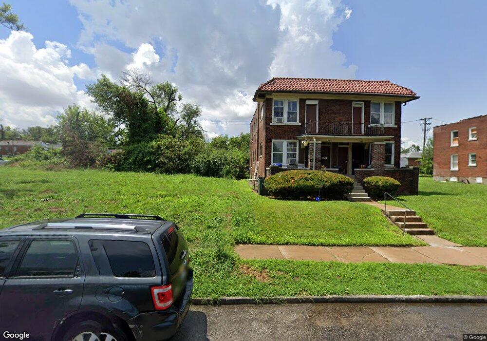
4512 Carter Ave Saint Louis, MO 63115
Penrose NeighborhoodEstimated Value: $48,000 - $81,000
Studio
--
Bath
--
Sq Ft
6,011
Sq Ft Lot
About This Home
This home is located at 4512 Carter Ave, Saint Louis, MO 63115 and is currently estimated at $62,000. 4512 Carter Ave is a home located in St. Louis City with nearby schools including Ashland Elementary School, Yeatman-Liddell Middle School, and Vashon High School.
Ownership History
Date
Name
Owned For
Owner Type
Purchase Details
Closed on
Oct 25, 2004
Sold by
Murphy James W
Bought by
Lra
Current Estimated Value
Purchase Details
Closed on
Dec 10, 1999
Sold by
Gerdine Thadeus
Bought by
Rogers Anntionette
Home Financials for this Owner
Home Financials are based on the most recent Mortgage that was taken out on this home.
Original Mortgage
$30,550
Interest Rate
8.19%
Mortgage Type
Purchase Money Mortgage
Purchase Details
Closed on
Sep 30, 1999
Sold by
Rogers Anntionette
Bought by
Strong Joyce A
Create a Home Valuation Report for This Property
The Home Valuation Report is an in-depth analysis detailing your home's value as well as a comparison with similar homes in the area
Home Values in the Area
Average Home Value in this Area
Purchase History
| Date | Buyer | Sale Price | Title Company |
|---|---|---|---|
| Lra | $2,500 | -- | |
| Rogers Anntionette | -- | Bankers Title Agency Inc | |
| Strong Joyce A | -- | Bankers Title Agency Inc |
Source: Public Records
Mortgage History
| Date | Status | Borrower | Loan Amount |
|---|---|---|---|
| Previous Owner | Rogers Anntionette | $30,550 | |
| Closed | Rogers Anntionette | $8,000 |
Source: Public Records
Tax History
| Year | Tax Paid | Tax Assessment Tax Assessment Total Assessment is a certain percentage of the fair market value that is determined by local assessors to be the total taxable value of land and additions on the property. | Land | Improvement |
|---|---|---|---|---|
| 2025 | -- | $610 | $610 | -- |
| 2024 | -- | $610 | $610 | -- |
| 2023 | -- | $610 | $610 | $0 |
| 2022 | -- | $610 | $610 | -- |
| 2021 | $0 | $610 | $610 | $0 |
| 2020 | $0 | $610 | $610 | $0 |
| 2019 | $0 | $610 | $610 | $0 |
| 2018 | $0 | $610 | $610 | $0 |
| 2017 | $0 | $610 | $610 | $0 |
| 2016 | $0 | $570 | $570 | $0 |
| 2015 | -- | $570 | $570 | $0 |
| 2014 | -- | $570 | $570 | $0 |
| 2013 | -- | $570 | $570 | $0 |
Source: Public Records
Map
Nearby Homes
- 4418 Dryden Ave
- 4556 Carter Ave
- 4627 Korte Ave
- 4475 N Taylor Ave
- 4410 Marcus Ave
- 4464 Lee Ave
- 4402 Clarence Ave
- 4709 Penrose St
- 4739 Bessie Ct
- 4608 Pope Ave
- 4341 Shreve Ave
- 4210 Holly Ave
- 4655 Farlin Ave
- 4215 Shreve Ave
- 4223 Athlone Ave
- 4450 Holly Ave
- 3003 TAYOR N Taylor Ave
- 4537 Clarence Ave
- 4534 Margaretta Ave
- 4707 Farlin Ave
- 4516 Carter Ave
- 4327 N Taylor Ave
- 4524 Carter Ave
- 4500 Carter Ave
- 4323 N Taylor Ave
- 4328 Dryden Ave
- 4528 Carter Ave
- 4321 N Taylor Ave
- 4324 Dryden Ave
- 4317 N Taylor Ave
- 4521 Carter Ave
- 4519 Carter Ave
- 4515 Carter Ave
- 4511 Carter Ave
- 4507 Carter Ave
- 4315 N Taylor Ave
- 4320 Dryden Ave
- 4482 Carter Ave
- 4523 Anderson Ave
- 4503 Carter Ave
Your Personal Tour Guide
Ask me questions while you tour the home.