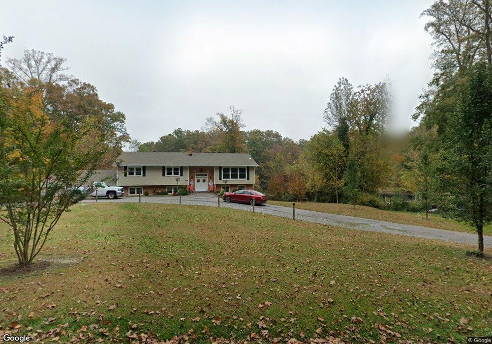
4512 Forrestal Rd Chester, VA 23831
Estimated Value: $553,000 - $613,000
5
Beds
5
Baths
4,217
Sq Ft
$136/Sq Ft
Est. Value
About This Home
This home is located at 4512 Forrestal Rd, Chester, VA 23831 and is currently estimated at $572,535, approximately $135 per square foot. 4512 Forrestal Rd is a home located in Chesterfield County with nearby schools including C.C. Wells Elementary School, George W. Carver Middle School, and Lloyd C Bird High School.
Ownership History
Date
Name
Owned For
Owner Type
Purchase Details
Closed on
Feb 21, 2018
Sold by
White Rex D and White Judith A
Bought by
White Rex D and White Judith A
Current Estimated Value
Create a Home Valuation Report for This Property
The Home Valuation Report is an in-depth analysis detailing your home's value as well as a comparison with similar homes in the area
Home Values in the Area
Average Home Value in this Area
Purchase History
| Date | Buyer | Sale Price | Title Company |
|---|---|---|---|
| White Rex D | -- | None Available |
Source: Public Records
Tax History
| Year | Tax Paid | Tax Assessment Tax Assessment Total Assessment is a certain percentage of the fair market value that is determined by local assessors to be the total taxable value of land and additions on the property. | Land | Improvement |
|---|---|---|---|---|
| 2025 | $4,709 | $526,300 | $102,000 | $424,300 |
| 2024 | $4,709 | $525,400 | $102,000 | $423,400 |
| 2023 | $4,393 | $482,800 | $102,000 | $380,800 |
| 2022 | $4,372 | $475,200 | $99,000 | $376,200 |
| 2021 | $3,991 | $413,200 | $97,000 | $316,200 |
| 2020 | $3,858 | $406,100 | $97,000 | $309,100 |
| 2019 | $3,630 | $382,100 | $96,000 | $286,100 |
| 2018 | $3,365 | $359,100 | $94,000 | $265,100 |
| 2017 | $2,964 | $308,800 | $94,000 | $214,800 |
| 2016 | $2,936 | $305,800 | $94,000 | $211,800 |
| 2015 | $2,925 | $302,100 | $94,000 | $208,100 |
| 2014 | $2,917 | $301,300 | $94,000 | $207,300 |
Source: Public Records
Map
Nearby Homes
- 13012 Harrowgate Rd
- 13101 Harrowgate Rd
- 4308 Hyde Park Dr
- 4248 Wells Ridge Ct
- 4331 Poplar Village Dr
- 4324 Poplar Village Dr
- 13225 Old Happy Hill Rd
- 4313 Poplar Village Dr
- 4306 Poplar Village Dr
- 12606 Poplar Village Place
- 12618 Poplar Village Place
- 4248 Poplar Village Dr
- 12601 Poplar Village Place
- The Cordova Plan at Poplar Village
- The Shenandoah Plan at Poplar Village
- The Westwood Plan at Poplar Village
- The Rowland Plan at Poplar Village
- The Charles Plan at Poplar Village
- The Stafford Plan at Poplar Village
- The Potomac Plan at Poplar Village
- 4518 Forrestal Rd
- 4506 Forrestal Rd
- 4500 Forrestal Rd
- 4509 Forrestal Rd
- 4511 Forrestal Rd
- 4523 Forrestal Rd
- 4505 Forrestal Rd
- 4524 Forrestal Rd
- 4527 Forrestal Rd
- 4501 Forrestal Rd
- 4524 Hemway Rd
- 4516 Hemway Rd
- 4535 Forrestal Rd
- 4532 Hemway Rd
- 4508 Hemway Rd
- 12800 Harrowgate Rd
- 4540 Hemway Rd
- 4534 Forrestal Rd
- 4500 Hemway Rd
- 12901 Harrowgate Rd
Your Personal Tour Guide
Ask me questions while you tour the home.