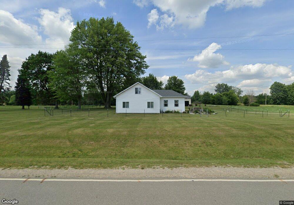
4516 W Muskrat Rd Sheridan, MI 48884
Estimated Value: $281,000
--
Bed
--
Bath
--
Sq Ft
3.98
Acres
About This Home
This home is located at 4516 W Muskrat Rd, Sheridan, MI 48884 and is currently estimated at $281,000. 4516 W Muskrat Rd is a home located in Montcalm County with nearby schools including Central Montcalm Elementary School, Central Montcalm Upper Elementary School, and Central Montcalm Middle School.
Ownership History
Date
Name
Owned For
Owner Type
Purchase Details
Closed on
May 1, 2023
Sold by
Petre Curtis R
Bought by
Petre Curtis R and Petre Mary Delcie
Current Estimated Value
Purchase Details
Closed on
May 9, 2008
Sold by
Fuller Larry and Fuller Teresa
Bought by
Crane Kenneth F and Crane Lynn M
Home Financials for this Owner
Home Financials are based on the most recent Mortgage that was taken out on this home.
Original Mortgage
$10,185
Interest Rate
6.01%
Mortgage Type
Purchase Money Mortgage
Purchase Details
Closed on
Feb 15, 2007
Sold by
Fuller Larry and Fuller Teresa
Bought by
Novastar Mortgage Inc
Purchase Details
Closed on
Mar 1, 2006
Sold by
Fuller Larry and Fuller Teresa
Bought by
Montcalm County Treasurer
Purchase Details
Closed on
Jul 14, 2000
Sold by
Hauber Joan E
Bought by
Fuller Larry and Fuller Teresa
Create a Home Valuation Report for This Property
The Home Valuation Report is an in-depth analysis detailing your home's value as well as a comparison with similar homes in the area
Home Values in the Area
Average Home Value in this Area
Purchase History
| Date | Buyer | Sale Price | Title Company |
|---|---|---|---|
| Petre Curtis R | -- | None Listed On Document | |
| Crane Kenneth F | $67,900 | -- | |
| Novastar Mortgage Inc | $103,152 | None Available | |
| Novastar Mortgage Inc | -- | -- | |
| Montcalm County Treasurer | -- | -- | |
| Fuller Larry | $110,900 | -- |
Source: Public Records
Mortgage History
| Date | Status | Borrower | Loan Amount |
|---|---|---|---|
| Previous Owner | Crane Kenneth F | $10,185 | |
| Previous Owner | Crane Kenneth F | $54,320 |
Source: Public Records
Tax History Compared to Growth
Tax History
| Year | Tax Paid | Tax Assessment Tax Assessment Total Assessment is a certain percentage of the fair market value that is determined by local assessors to be the total taxable value of land and additions on the property. | Land | Improvement |
|---|---|---|---|---|
| 2025 | $569 | $15,500 | $0 | $0 |
| 2024 | $585 | $13,700 | $0 | $0 |
| 2023 | -- | $13,000 | $0 | $0 |
| 2022 | -- | $12,000 | $0 | $0 |
| 2021 | -- | $11,500 | $0 | $0 |
| 2020 | -- | -- | $0 | $0 |
| 2019 | -- | -- | $0 | $0 |
| 2018 | -- | -- | $0 | $0 |
| 2017 | -- | -- | $0 | $0 |
| 2016 | -- | -- | $0 | $0 |
| 2015 | -- | -- | $0 | $0 |
| 2014 | -- | -- | $0 | $0 |
Source: Public Records
Map
Nearby Homes
- 4366 W Woods Rd
- 4829 S Derby Rd
- 3138 S Miller Rd
- VL S Grow Rd
- 5265 Huck Dr
- 3955 S Holland Rd
- 4872 W Carson City Rd
- 1361 S Derby Rd
- 104 Bliss Ct
- 8040 S Backus Rd
- V/L Industrial Park Dr
- 6325 S Greenville Rd
- 9363 S Grow Rd
- 4790 S Greenville Rd
- 814 E Coffren Ave
- 1034 Thompson St SW
- 4263 S Sheridan Rd
- 601 S Main St
- 812 N 4th St
- 231 E Smith St
- 4516 W Muskrat Rd
- 4627 W Muskrat Rd
- 4724 W Muskrat Rd
- 4808 S Miles Rd
- 4380 W Muskrat Rd
- 4895 S Miles Rd
- 4895 S Miles Rd
- 4811 S Miles Rd
- 4362 W Muskrat Rd
- 4772 S Miles Rd
- 4780 W Muskrat Rd
- 0 W Muskrat Rd
- 5 W Muskrat Rd
- 4804 W Muskrat Rd
- 4300 W Muskrat Rd
- 4709 S Miles Rd
- 5231 S Miles Rd
- 4318 W Muskrat Rd
- 4425 Meadow Ln
- 4230 W Muskrat Rd