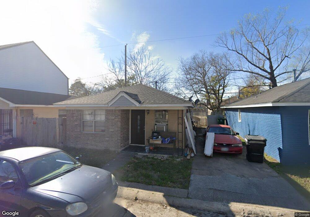
4519 Lelay Cir Houston, TX 77022
Independence Heights NeighborhoodEstimated Value: $155,938 - $216,000
2
Beds
1
Bath
862
Sq Ft
$204/Sq Ft
Est. Value
About This Home
This home is located at 4519 Lelay Cir, Houston, TX 77022 and is currently estimated at $175,735, approximately $203 per square foot. 4519 Lelay Cir is a home located in Harris County with nearby schools including Kennedy Elementary School, Williams Middle, and Booker T Washington Sr High.
Ownership History
Date
Name
Owned For
Owner Type
Purchase Details
Closed on
Jun 18, 1999
Sold by
Phrater Inc
Bought by
Arredondo Jorge H and Arredondo Marianno
Current Estimated Value
Home Financials for this Owner
Home Financials are based on the most recent Mortgage that was taken out on this home.
Original Mortgage
$36,100
Outstanding Balance
$9,568
Interest Rate
7.11%
Estimated Equity
$166,167
Purchase Details
Closed on
Jul 24, 1997
Sold by
Drennan Ulrick
Bought by
Phrater Inc
Create a Home Valuation Report for This Property
The Home Valuation Report is an in-depth analysis detailing your home's value as well as a comparison with similar homes in the area
Home Values in the Area
Average Home Value in this Area
Purchase History
| Date | Buyer | Sale Price | Title Company |
|---|---|---|---|
| Arredondo Jorge H | -- | -- | |
| Phrater Inc | -- | -- |
Source: Public Records
Mortgage History
| Date | Status | Borrower | Loan Amount |
|---|---|---|---|
| Open | Arredondo Jorge H | $36,100 |
Source: Public Records
Tax History Compared to Growth
Tax History
| Year | Tax Paid | Tax Assessment Tax Assessment Total Assessment is a certain percentage of the fair market value that is determined by local assessors to be the total taxable value of land and additions on the property. | Land | Improvement |
|---|---|---|---|---|
| 2025 | $2,423 | $120,053 | $33,707 | $86,346 |
| 2024 | $2,423 | $121,971 | $33,707 | $88,264 |
| 2023 | $2,423 | $96,506 | $33,707 | $62,799 |
| 2022 | $2,125 | $96,506 | $33,707 | $62,799 |
| 2021 | $1,426 | $61,177 | $13,879 | $47,298 |
| 2020 | $1,481 | $61,177 | $13,879 | $47,298 |
| 2019 | $1,296 | $51,221 | $13,879 | $37,342 |
| 2018 | $1,138 | $44,971 | $13,879 | $31,092 |
| 2017 | $1,137 | $44,971 | $13,879 | $31,092 |
| 2016 | $785 | $31,030 | $4,957 | $26,073 |
| 2015 | $798 | $31,030 | $4,957 | $26,073 |
| 2014 | $798 | $31,030 | $4,957 | $26,073 |
Source: Public Records
Map
Nearby Homes
- 144 Knightsbridge Park Ln
- 147 Knightsbridge Park Ln
- 107 W Whitney St Unit E
- 107 W Whitney St Unit C
- 4423 Yale St
- 225 Noras Ln Unit E
- 8901 N Main St
- 4510 Old Yale St Unit A
- 115 E Thornton Rd
- 4435 Whitney Oak Ln
- 310 Walthall Dr
- 312 Walthall Dr
- 315 E Whitney St
- 0 Victoria Unit 54691087
- 4605 Yale St Unit C
- 4605 Yale St Unit A
- 4605 Yale St Unit J
- 320 Thornton Rd
- 0 E 45th St
- 303 Victoria Dr
- 4523 Lelay Cir
- 4515 Lelay Cir
- 4518 Pecan Park Cir
- 4522 Pecan Park Cir
- 4514 Pecan Park Cir
- 4527 Lelay Cir
- 4511 Lelay Cir
- 4526 Pecan Park Cir
- 4510 Pecan Park Cir
- 4518 Lelay Cir
- 4522 Lelay Cir
- 4514 Lelay Cir
- 4531 Lelay Cir
- 4507 Lelay Cir
- 4526 Lelay Cir
- 4530 Pecan Park Cir
- 4510 Lelay Cir
- 4506 Pecan Park Cir
- 4503 Lelay Cir
- 4506 Lelay Cir