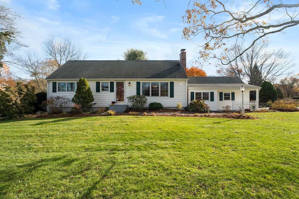
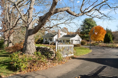
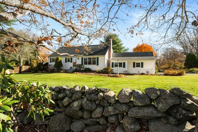
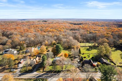
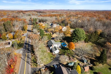
452 Colonel Ledyard Hwy Ledyard, CT 06339
Estimated payment $3,193/month
Highlights
- Above Ground Pool
- Property is near shops
- Ceiling Fan
- Cape Cod Architecture
- Hot Water Circulator
- Hot Water Heating System
About This Home
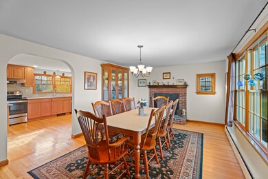
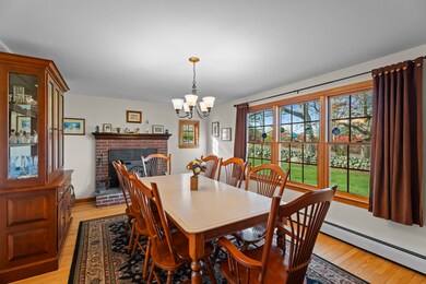
Embrace the charm of country living in this turn-key four-bedroom Cape filled with warmth and modern updates. The first floor offers a primary bedroom, guest room, and full bath. Upstairs, two inviting bedrooms share another full bath. The updated kitchen opens to a cozy family room and large deck-perfect for gatherings or quiet mornings surrounded by nature. A partially finished basement offers space for a rec room, gym, or workshop. Stone walls, newer fencing, and a gated driveway frame the beautifully landscaped grounds with seasonal gardens. Enjoy an attached garage, above-ground pool, and new basketball hoop-country living at its best!
Listing Agent
Switz Real Estate Associates Brokerage Phone: (860) 460-2445 License #RES.0829833 Listed on: 11/11/2025
Open House Schedule
-
Monday, November 17, 202512:00 to 3:00 pm11/17/2025 12:00:00 PM +00:0011/17/2025 3:00:00 PM +00:00Add to Calendar
Home Details
Home Type
- Single Family
Est. Annual Taxes
- $6,887
Year Built
- Built in 1967
Lot Details
- 0.54 Acre Lot
- Level Lot
- Property is zoned R60
Home Design
- Cape Cod Architecture
- Concrete Foundation
- Frame Construction
- Asphalt Shingled Roof
- Vinyl Siding
- Radon Mitigation System
Interior Spaces
- 1,987 Sq Ft Home
- Ceiling Fan
- Basement Fills Entire Space Under The House
Kitchen
- Electric Cooktop
- Range Hood
- Dishwasher
Bedrooms and Bathrooms
- 4 Bedrooms
- 2 Full Bathrooms
Laundry
- Laundry on main level
- Dryer
- Washer
Parking
- 1 Car Garage
- Private Driveway
Schools
- Gallup Hill Elementary School
- Ledyard High School
Utilities
- Mini Split Air Conditioners
- Hot Water Heating System
- Heating System Uses Oil
- Heating System Uses Wood
- Private Company Owned Well
- Hot Water Circulator
- Fuel Tank Located in Basement
Additional Features
- Above Ground Pool
- Property is near shops
Listing and Financial Details
- Assessor Parcel Number 1514236
Map
Home Values in the Area
Average Home Value in this Area
Tax History
| Year | Tax Paid | Tax Assessment Tax Assessment Total Assessment is a certain percentage of the fair market value that is determined by local assessors to be the total taxable value of land and additions on the property. | Land | Improvement |
|---|---|---|---|---|
| 2025 | $6,887 | $185,430 | $45,080 | $140,350 |
| 2024 | $6,507 | $184,800 | $45,080 | $139,720 |
| 2023 | $6,387 | $184,800 | $45,080 | $139,720 |
| 2022 | $6,250 | $184,800 | $45,080 | $139,720 |
| 2021 | $6,209 | $184,800 | $45,080 | $139,720 |
| 2020 | $5,713 | $163,380 | $42,840 | $120,540 |
| 2019 | $5,728 | $163,380 | $42,840 | $120,540 |
| 2018 | $5,602 | $163,380 | $42,840 | $120,540 |
| 2017 | $5,316 | $163,380 | $42,840 | $120,540 |
| 2016 | $5,212 | $163,380 | $42,840 | $120,540 |
| 2015 | $4,967 | $163,380 | $42,840 | $120,540 |
| 2014 | $5,191 | $173,600 | $45,080 | $128,520 |
Purchase History
| Date | Type | Sale Price | Title Company |
|---|---|---|---|
| Warranty Deed | $275,000 | -- | |
| Warranty Deed | $136,000 | -- |
Mortgage History
| Date | Status | Loan Amount | Loan Type |
|---|---|---|---|
| Open | $200,000 | New Conventional | |
| Previous Owner | $69,000 | No Value Available | |
| Previous Owner | $146,000 | No Value Available | |
| Previous Owner | $23,000 | No Value Available |
Source: SmartMLS
MLS Number: 24139610
APN: LEDY-000114-000530-000452
Disclaimer: Certain information contained herein is derived from information provided by parties other than Homes.com. All information provided is deemed reliable, but is not guaranteed to be accurate and should be independently verified.
![]() IDX information is provided exclusively for personal, non-commercial use, and may not be used for any purpose other than to identify prospective properties consumers may be interested in purchasing. Information is deemed reliable but not guaranteed.
IDX information is provided exclusively for personal, non-commercial use, and may not be used for any purpose other than to identify prospective properties consumers may be interested in purchasing. Information is deemed reliable but not guaranteed.
- 173 Lambtown Rd
- 528 Colonel Ledyard Hwy
- 2 Autumn Way
- 17 Autumn Way
- 148 Gallup Hill Rd
- 9 Reservoir View
- 146 Gallup Hill Rd
- 254 Haley Rd
- 1719 Center Groton Rd
- 22 Boulder Way
- 3 Cliff Rd
- 8 Powder Horn Ln
- 22 Cliff Rd
- 75 Heather Glen Ln
- 22 Spring Valley Rd
- 12 Cartridge Trail
- 1663 Center Groton Rd
- 36 Watrous Ave
- 19 Center Dr
- 6 Wolf Ridge Gap
- 317 Heather Glen Ln
- 205 Colonel Ledyard Hwy
- 5H Flintlock Rd
- 29 Meeting House Ln
- 14 Boulder Way
- 2350 Gold Star Hwy Unit 5
- 17 Heather Glen Ln
- 24 Larchmont Terrace
- 90 Godfrey Rd
- 188 Wolf Neck Rd
- 152 Whitehall Ave
- 20 Prentice Williams Rd
- 66 Long Pond Rd S
- 424 Pequot Ave
- 12 Melanie Ln
- 405 Noank Ledyard Rd
- 7 Conrad St
- 76 Merlino Dr
- 50 Perkins Farm Dr Unit 120 - The Vineyard
- 50 Perkins Farm Dr Unit 115 - Sag Harbor
