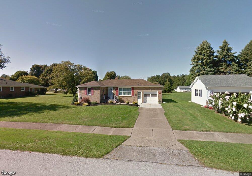
452 Residence St Conneaut, OH 44030
Estimated Value: $138,186 - $181,000
3
Beds
1
Bath
956
Sq Ft
$163/Sq Ft
Est. Value
About This Home
This home is located at 452 Residence St, Conneaut, OH 44030 and is currently estimated at $155,547, approximately $162 per square foot. 452 Residence St is a home located in Ashtabula County with nearby schools including Lakeshore Primary Elementary School, Gateway Elementary School, and Conneaut Middle School.
Ownership History
Date
Name
Owned For
Owner Type
Purchase Details
Closed on
Sep 9, 2009
Sold by
Drummond Beverly A and Drummond David A
Bought by
Carlucci Mark
Current Estimated Value
Home Financials for this Owner
Home Financials are based on the most recent Mortgage that was taken out on this home.
Original Mortgage
$68,000
Interest Rate
5.27%
Mortgage Type
New Conventional
Create a Home Valuation Report for This Property
The Home Valuation Report is an in-depth analysis detailing your home's value as well as a comparison with similar homes in the area
Home Values in the Area
Average Home Value in this Area
Purchase History
| Date | Buyer | Sale Price | Title Company |
|---|---|---|---|
| Carlucci Mark | $68,000 | Chicago Title Agency |
Source: Public Records
Mortgage History
| Date | Status | Borrower | Loan Amount |
|---|---|---|---|
| Previous Owner | Carlucci Mark | $68,000 |
Source: Public Records
Tax History Compared to Growth
Tax History
| Year | Tax Paid | Tax Assessment Tax Assessment Total Assessment is a certain percentage of the fair market value that is determined by local assessors to be the total taxable value of land and additions on the property. | Land | Improvement |
|---|---|---|---|---|
| 2024 | $2,735 | $37,390 | $6,270 | $31,120 |
| 2023 | $1,739 | $37,390 | $6,270 | $31,120 |
| 2022 | $1,473 | $27,860 | $4,830 | $23,030 |
| 2021 | $1,499 | $27,860 | $4,830 | $23,030 |
| 2020 | $1,498 | $27,860 | $4,830 | $23,030 |
| 2019 | $1,334 | $24,360 | $4,830 | $19,530 |
| 2018 | $1,272 | $24,360 | $4,830 | $19,530 |
| 2017 | $1,270 | $24,360 | $4,830 | $19,530 |
| 2016 | $1,127 | $23,560 | $4,690 | $18,870 |
| 2015 | $2,132 | $23,560 | $4,690 | $18,870 |
| 2014 | $942 | $22,160 | $4,690 | $17,470 |
| 2013 | $1,061 | $25,690 | $4,410 | $21,280 |
Source: Public Records
Map
Nearby Homes
- 716 Chestnut St
- 0 Chestnut St Unit 5120761
- 688 Grove St
- 644 Mill St
- 630 Mill St
- 703 Sandusky St
- 405 Bliss Ave
- 533 Mill St
- 381 Bliss Ave
- 536 Mill St
- 554 Sandusky St
- 429 Depot St
- 459 Mill St
- 770 Buffalo St
- 794 Buffalo St
- 448 Sandusky St Unit 450
- 281 Depot St
- 169 River St
- 973 Buffalo St
- 179 Hayward Ave
- 444 Residence St
- 466 Residence St
- 676 Chestnut St
- 644 Chestnut St
- 678 Chestnut St
- 668 Orange St
- 694 Residence St
- 709 Wrights Ave
- 642 Chestnut St
- 429 Residence St
- 680 Chestnut St
- 715 Wrights Ave
- 650 Orange St
- 653 Chestnut St
- 634 Chestnut St
- 651 Wrights Ave
- 717 Wrights Ave
- 681 Chestnut St
- 632 Chestnut St
- 710 Chestnut St