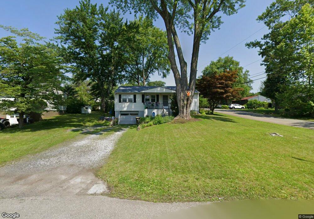
452 Youngwood Dr East Stroudsburg, PA 18301
Estimated Value: $235,859 - $301,000
3
Beds
2
Baths
1,120
Sq Ft
$244/Sq Ft
Est. Value
About This Home
This home is located at 452 Youngwood Dr, East Stroudsburg, PA 18301 and is currently estimated at $273,215, approximately $243 per square foot. 452 Youngwood Dr is a home located in Monroe County with nearby schools including Stroudsburg Junior High School, Stroudsburg High School, and Summit School Of The Poconos.
Ownership History
Date
Name
Owned For
Owner Type
Purchase Details
Closed on
Aug 25, 2023
Sold by
Adam Louis R
Bought by
Adam Louis R
Current Estimated Value
Home Financials for this Owner
Home Financials are based on the most recent Mortgage that was taken out on this home.
Original Mortgage
$60,000
Interest Rate
6.96%
Mortgage Type
Credit Line Revolving
Purchase Details
Closed on
Feb 28, 2003
Bought by
Adam Louis R and Adam Valerie J
Create a Home Valuation Report for This Property
The Home Valuation Report is an in-depth analysis detailing your home's value as well as a comparison with similar homes in the area
Home Values in the Area
Average Home Value in this Area
Purchase History
| Date | Buyer | Sale Price | Title Company |
|---|---|---|---|
| Adam Louis R | -- | Pocono Property Abstract | |
| Adam Louis R | -- | -- |
Source: Public Records
Mortgage History
| Date | Status | Borrower | Loan Amount |
|---|---|---|---|
| Open | Adam Louis R | $140,000 | |
| Closed | Adam Louis R | $60,000 |
Source: Public Records
Tax History Compared to Growth
Tax History
| Year | Tax Paid | Tax Assessment Tax Assessment Total Assessment is a certain percentage of the fair market value that is determined by local assessors to be the total taxable value of land and additions on the property. | Land | Improvement |
|---|---|---|---|---|
| 2025 | $861 | $104,450 | $18,600 | $85,850 |
| 2024 | $704 | $104,450 | $18,600 | $85,850 |
| 2023 | $3,487 | $104,450 | $18,600 | $85,850 |
| 2022 | $3,560 | $104,450 | $18,600 | $85,850 |
| 2021 | $3,451 | $104,450 | $18,600 | $85,850 |
| 2020 | $3,022 | $104,450 | $18,600 | $85,850 |
| 2019 | $3,424 | $18,160 | $3,050 | $15,110 |
| 2018 | $3,653 | $18,160 | $3,050 | $15,110 |
| 2017 | $3,653 | $18,160 | $3,050 | $15,110 |
| 2016 | $687 | $18,160 | $3,050 | $15,110 |
| 2015 | -- | $18,160 | $3,050 | $15,110 |
| 2014 | -- | $18,160 | $3,050 | $15,110 |
Source: Public Records
Map
Nearby Homes
- 118 Burgoon Rd
- 720 Stokes Mill Rd
- 0 Seneca Way
- 772 Mohawk Trail
- 0 Monroe-Heights Rd
- 179 King St
- 137 Berwick Heights Rd
- 1191 Appenzeller Ave
- 0 Eagle Drive (Bush) Ct
- 1184 Appenzeller Ave
- 3 Oakland Ave
- 1 Oakland Ave
- 144 W Broad St
- 727 Milford Rd
- 198 Grove St
- 508 S of T 508
- 202 N Courtland St Unit 1 & 2
- 202 N Courtland St
- 197 Meyers St
- 916 Mt Zion Ave
- 454 Youngwood Dr
- 589 Circle Dr
- 458 Youngwood Dr
- 600 Circle Dr
- 451 Youngwood Dr
- 596 Circle Dr
- 518 Schubert Rd
- 579 Circle Dr
- 453 Youngwood Dr
- 556 Circle Dr
- 592 Circle Dr
- 461 Youngwood Dr
- 516 Schubert Rd
- 560 Circle Dr
- 564 Circle Dr
- 606 Circle Dr
- 608 Circle Dr
- 604 Circle Dr
- 514 Schubert Rd
- 584 Circle Dr