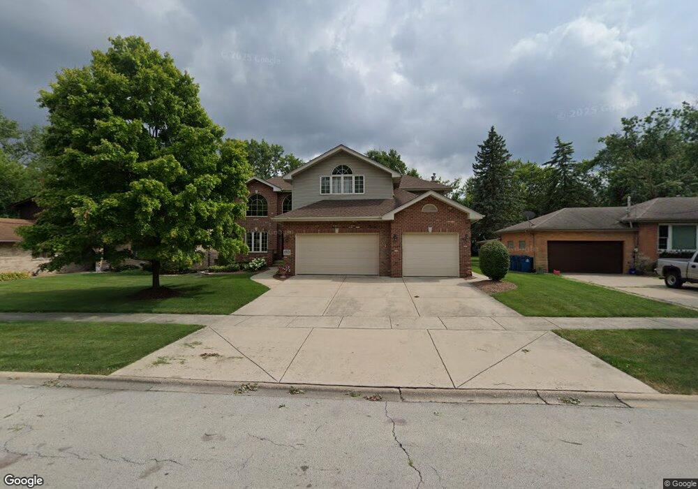
4525 149th St Midlothian, IL 60445
Estimated Value: $386,000 - $492,608
4
Beds
5
Baths
3,382
Sq Ft
$130/Sq Ft
Est. Value
About This Home
This home is located at 4525 149th St, Midlothian, IL 60445 and is currently estimated at $438,152, approximately $129 per square foot. 4525 149th St is a home located in Cook County with nearby schools including Kolmar Elementary School, Bremen High School, and St. Christopher School.
Ownership History
Date
Name
Owned For
Owner Type
Purchase Details
Closed on
Dec 21, 2022
Sold by
Duggan Michael T and Duggan Mary J
Bought by
Duggan Family Living Trust
Current Estimated Value
Purchase Details
Closed on
Apr 6, 2001
Sold by
Nlsb
Bought by
Duggan Michael T and Duggan Mary J
Home Financials for this Owner
Home Financials are based on the most recent Mortgage that was taken out on this home.
Original Mortgage
$70,000
Interest Rate
7.05%
Create a Home Valuation Report for This Property
The Home Valuation Report is an in-depth analysis detailing your home's value as well as a comparison with similar homes in the area
Home Values in the Area
Average Home Value in this Area
Purchase History
| Date | Buyer | Sale Price | Title Company |
|---|---|---|---|
| Duggan Family Living Trust | -- | None Listed On Document | |
| Duggan Michael T | -- | -- |
Source: Public Records
Mortgage History
| Date | Status | Borrower | Loan Amount |
|---|---|---|---|
| Previous Owner | Duggan Michael T | $70,000 |
Source: Public Records
Tax History
| Year | Tax Paid | Tax Assessment Tax Assessment Total Assessment is a certain percentage of the fair market value that is determined by local assessors to be the total taxable value of land and additions on the property. | Land | Improvement |
|---|---|---|---|---|
| 2025 | $13,505 | $39,000 | $7,665 | $31,335 |
| 2024 | $13,505 | $39,000 | $7,665 | $31,335 |
| 2023 | $12,681 | $39,000 | $7,665 | $31,335 |
| 2022 | $12,681 | $30,411 | $6,570 | $23,841 |
| 2021 | $12,232 | $30,410 | $6,570 | $23,840 |
| 2020 | $11,747 | $30,410 | $6,570 | $23,840 |
| 2019 | $11,783 | $30,557 | $6,022 | $24,535 |
| 2018 | $11,594 | $30,557 | $6,022 | $24,535 |
| 2017 | $11,199 | $30,557 | $6,022 | $24,535 |
| 2016 | $10,419 | $26,782 | $5,475 | $21,307 |
| 2015 | $10,134 | $26,782 | $5,475 | $21,307 |
| 2014 | $9,857 | $26,782 | $5,475 | $21,307 |
| 2013 | $10,295 | $30,772 | $5,475 | $25,297 |
Source: Public Records
Map
Nearby Homes
- 14927 Kenton Ave
- 14632 Kostner Ave
- 4519 152nd St
- 14602 Kenton Ave
- 15213 Waverly Ave
- 14545 Kostner Ave
- 14540 Kolin Ave
- 14528 Kolin Ave
- 14506 Knox Ave
- 14448 Kilbourne Ave
- 14837 Karlov Ave
- 14913 Sheila Ct
- 14903 Terrace Ln
- 14641 Lavergne Ave
- 15201 Lavergne Ave
- 4031 147th St
- 4010 150th St Unit 10
- 14970 Pulaski Rd Unit 5
- 14348 Kolmar Ave
- 14401 Kolin Ave
- 4519 149th St
- 4533 149th St
- 14940 Kilbourne Ave
- 4501 149th St
- 4520 149th St
- 4543 149th St
- 4543 149th St
- 4543 149th St
- 4543 149th St
- 4536 149th St
- 4547 149th St
- 4500 149th St
- 14912 Kilbourne Ave
- 4540 149th St
- 4451 149th St
- 14916 Kilbourne Ave
- 14916 Kilbourn Ave
- 14911 Kenton Ave
- 14901 Kenton Ave
- 14917 Kenton Ave
Your Personal Tour Guide
Ask me questions while you tour the home.