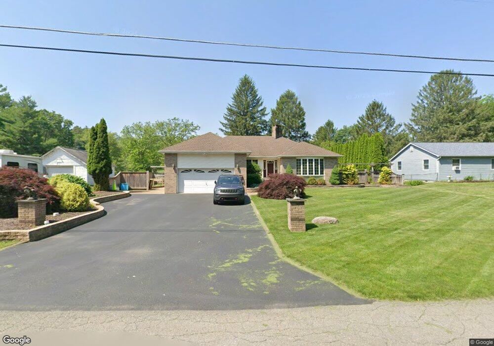
453 Cottontail Ln East Stroudsburg, PA 18301
Estimated Value: $251,000 - $376,000
3
Beds
2
Baths
2,000
Sq Ft
$165/Sq Ft
Est. Value
About This Home
This home is located at 453 Cottontail Ln, East Stroudsburg, PA 18301 and is currently estimated at $330,430, approximately $165 per square foot. 453 Cottontail Ln is a home with nearby schools including Stroudsburg Junior High School, Stroudsburg High School, and Summit School Of The Poconos.
Ownership History
Date
Name
Owned For
Owner Type
Purchase Details
Closed on
Apr 11, 2012
Sold by
Skyline Steel Fab & Erectors Inc
Bought by
Thompson Bruce E
Current Estimated Value
Home Financials for this Owner
Home Financials are based on the most recent Mortgage that was taken out on this home.
Original Mortgage
$72,972
Outstanding Balance
$30,516
Interest Rate
3.91%
Mortgage Type
FHA
Estimated Equity
$299,915
Create a Home Valuation Report for This Property
The Home Valuation Report is an in-depth analysis detailing your home's value as well as a comparison with similar homes in the area
Home Values in the Area
Average Home Value in this Area
Purchase History
| Date | Buyer | Sale Price | Title Company |
|---|---|---|---|
| Thompson Bruce E | $85,000 | None Available |
Source: Public Records
Mortgage History
| Date | Status | Borrower | Loan Amount |
|---|---|---|---|
| Open | Thompson Bruce E | $72,972 |
Source: Public Records
Tax History Compared to Growth
Tax History
| Year | Tax Paid | Tax Assessment Tax Assessment Total Assessment is a certain percentage of the fair market value that is determined by local assessors to be the total taxable value of land and additions on the property. | Land | Improvement |
|---|---|---|---|---|
| 2025 | $1,435 | $174,040 | $20,760 | $153,280 |
| 2024 | $1,174 | $174,040 | $20,760 | $153,280 |
| 2023 | $5,810 | $174,040 | $20,760 | $153,280 |
| 2022 | $5,932 | $174,040 | $20,760 | $153,280 |
| 2021 | $5,750 | $174,040 | $20,760 | $153,280 |
| 2020 | $5,290 | $174,040 | $20,760 | $153,280 |
| 2019 | $7,406 | $39,280 | $6,830 | $32,450 |
| 2018 | $7,901 | $39,280 | $6,830 | $32,450 |
| 2017 | $7,901 | $39,280 | $6,830 | $32,450 |
| 2016 | $1,487 | $39,280 | $6,830 | $32,450 |
| 2015 | -- | $39,280 | $6,830 | $32,450 |
| 2014 | -- | $39,280 | $6,830 | $32,450 |
Source: Public Records
Map
Nearby Homes
- 720 Stokes Mill Rd
- 0 Seneca Way
- 179 King St
- 118 Burgoon Rd
- 137 Berwick Heights Rd
- 1191 Appenzeller Ave
- 1184 Appenzeller Ave
- 0 Monroe-Heights Rd
- 3 Oakland Ave
- 1 Oakland Ave
- 144 W Broad St
- 0 Eagle Drive (Bush) Ct
- 198 Grove St
- 202 N Courtland St Unit 1 & 2
- 202 N Courtland St
- 197 Meyers St
- 204 Lackawanna Ave
- 727 Milford Rd
- 182 State St
- 521 Emerald Ct
- 459 Cottontail Ln
- 449 Cottontail Ln
- 456 White Birch St
- 438 Cottontail Ln
- 450 Cottontail Ln
- 6480 White Birch St
- 480 White Birch St
- 6450 White Birch St
- 497 Mill Creek Rd
- 479 Stokes Ave
- 497 Stokes Ave Unit 1
- 495 Mill Creek Rd
- 497 Stokes Ave
- 443 Farm St
- 15 Cottontail Ln
- 479 Mill Creek Rd
- 446 White Birch St
- 496 White Birch St
- 6457 White Birch St
- 431 Farm St