Estimated Value: $302,876 - $368,000
4
Beds
2
Baths
2,340
Sq Ft
$143/Sq Ft
Est. Value
About This Home
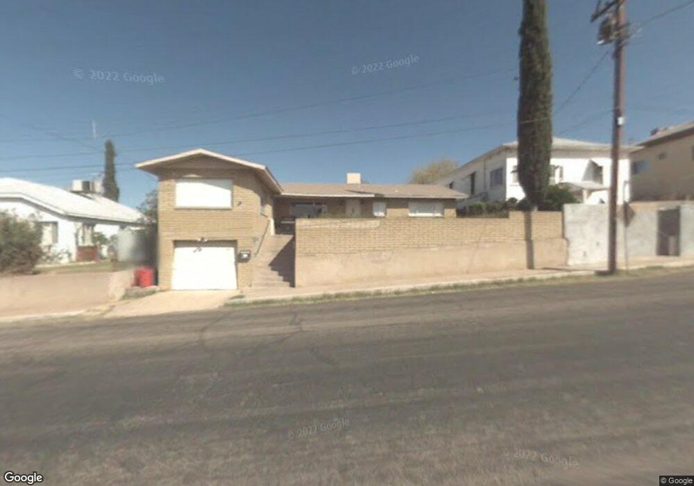
This home is located at 453 E Cedar St, Globe, AZ 85501 and is currently estimated at $334,969, approximately $143 per square foot. 453 E Cedar St is a home located in Gila County with nearby schools including Copper Rim Elementary School, High Desert Middle School, and Globe High School.
Ownership History
Date
Name
Owned For
Owner Type
Purchase Details
Closed on
Mar 27, 2025
Sold by
Peeler Family Trust and Peeler Owen Maxwell
Bought by
Falquez Sabrina N
Current Estimated Value
Home Financials for this Owner
Home Financials are based on the most recent Mortgage that was taken out on this home.
Original Mortgage
$318,181
Outstanding Balance
$315,435
Interest Rate
6.87%
Mortgage Type
New Conventional
Estimated Equity
$19,534
Purchase Details
Closed on
May 31, 2022
Sold by
Terry Wilson
Bought by
Peeler Family Trust
Purchase Details
Closed on
Jul 11, 2011
Sold by
Us Bank National Association
Bought by
Wilson Terry L
Home Financials for this Owner
Home Financials are based on the most recent Mortgage that was taken out on this home.
Original Mortgage
$82,747
Interest Rate
4.62%
Mortgage Type
FHA
Purchase Details
Closed on
Apr 8, 2011
Sold by
Mendibles Mark P and Mendibles Virginia
Bought by
Us Bank National Association
Create a Home Valuation Report for This Property
The Home Valuation Report is an in-depth analysis detailing your home's value as well as a comparison with similar homes in the area
Home Values in the Area
Average Home Value in this Area
Purchase History
| Date | Buyer | Sale Price | Title Company |
|---|---|---|---|
| Falquez Sabrina N | $315,000 | Pioneer Title | |
| Peeler Family Trust | $225,000 | None Listed On Document | |
| Wilson Terry L | $84,900 | Servicelink | |
| Us Bank National Association | $86,275 | Pioneer Title Agency |
Source: Public Records
Mortgage History
| Date | Status | Borrower | Loan Amount |
|---|---|---|---|
| Open | Falquez Sabrina N | $318,181 | |
| Previous Owner | Wilson Terry L | $82,747 |
Source: Public Records
Tax History
| Year | Tax Paid | Tax Assessment Tax Assessment Total Assessment is a certain percentage of the fair market value that is determined by local assessors to be the total taxable value of land and additions on the property. | Land | Improvement |
|---|---|---|---|---|
| 2026 | $1,472 | $34,604 | $941 | $33,663 |
| 2025 | $1,472 | -- | -- | -- |
| 2024 | $1,361 | $27,724 | $785 | $26,939 |
| 2023 | $1,361 | $20,568 | $635 | $19,933 |
| 2022 | $1,333 | $14,144 | $635 | $13,509 |
| 2021 | $1,428 | $14,144 | $635 | $13,509 |
| 2020 | $1,324 | $0 | $0 | $0 |
| 2019 | $1,305 | $0 | $0 | $0 |
| 2018 | $1,248 | $0 | $0 | $0 |
| 2017 | $1,189 | $0 | $0 | $0 |
| 2016 | $1,068 | $0 | $0 | $0 |
| 2015 | $1,009 | $0 | $0 | $0 |
Source: Public Records
Map
Nearby Homes
- 501 E Mesquite St
- 339 N Devereaux St
- 543 E Mesquite St
- 196 E Cedar St
- 0000 Bailey -- Unit 1
- 258 S Sutherland St
- 415 N Hill St
- 0 Cottonwood Unit 1806700
- 254 N Broad St
- 227 S First St
- 300 N Broad St
- 396 N Broad St
- 877 E Sycamore St
- 385 S Broad St
- 449 S East St
- 610 N Broad St
- 360 W Bailey St
- 840 N Devereaux St
- 523 E Copper Hills Rd
- 595 N Fourth St
- 455 E Cedar St
- 401 E Cedar St
- 457 E Cedar St
- 254 N High St
- 430 E Mesquite St
- 450 E Mesquite St
- 428 E Cedar St
- 442 E Cedar St
- 363 E Cedar St
- 462 E Cedar St
- 420 E Cedar St
- 470 E Mesquite St
- 482 E Cedar St
- 247 N High St
- 351 E Cedar St
- 246 N Devereaux St
- 382 E Cedar St
- 257 N High St
- 139 N Devereaux St
- 277 N High St
Your Personal Tour Guide
Ask me questions while you tour the home.