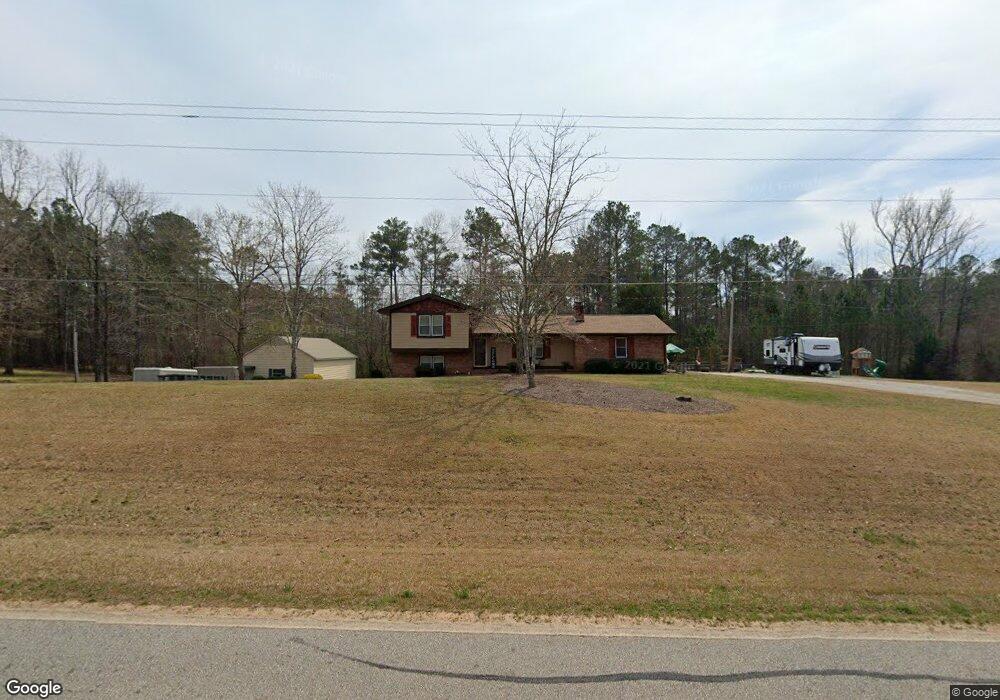
453 Earl North Rd Newnan, GA 30263
Estimated Value: $349,000 - $392,000
3
Beds
3
Baths
2,805
Sq Ft
$130/Sq Ft
Est. Value
About This Home
This home is located at 453 Earl North Rd, Newnan, GA 30263 and is currently estimated at $365,993, approximately $130 per square foot. 453 Earl North Rd is a home located in Coweta County with nearby schools including Atkinson Elementary School, Smokey Road Middle School, and Newnan High School.
Ownership History
Date
Name
Owned For
Owner Type
Purchase Details
Closed on
Oct 15, 2007
Sold by
Kimble Robert J and Kimble Tammie D
Bought by
Kimble Robert J
Current Estimated Value
Purchase Details
Closed on
Dec 13, 2002
Sold by
Kimble Robert J
Bought by
Kimble Robert J and Kimble Tammie D
Home Financials for this Owner
Home Financials are based on the most recent Mortgage that was taken out on this home.
Original Mortgage
$80,000
Interest Rate
6.07%
Mortgage Type
New Conventional
Purchase Details
Closed on
Nov 22, 1989
Bought by
Kimble Robert James
Create a Home Valuation Report for This Property
The Home Valuation Report is an in-depth analysis detailing your home's value as well as a comparison with similar homes in the area
Home Values in the Area
Average Home Value in this Area
Purchase History
| Date | Buyer | Sale Price | Title Company |
|---|---|---|---|
| Kimble Robert J | -- | -- | |
| Kimble Robert J | -- | -- | |
| Kimble Robert James | $61,000 | -- |
Source: Public Records
Mortgage History
| Date | Status | Borrower | Loan Amount |
|---|---|---|---|
| Previous Owner | Kimble Robert J | $80,000 |
Source: Public Records
Tax History Compared to Growth
Tax History
| Year | Tax Paid | Tax Assessment Tax Assessment Total Assessment is a certain percentage of the fair market value that is determined by local assessors to be the total taxable value of land and additions on the property. | Land | Improvement |
|---|---|---|---|---|
| 2024 | $2,115 | $95,723 | $5,642 | $90,081 |
| 2023 | $2,115 | $105,029 | $9,494 | $95,535 |
| 2022 | $1,617 | $70,338 | $5,425 | $64,913 |
| 2021 | $1,599 | $65,417 | $5,167 | $60,250 |
| 2020 | $1,609 | $65,417 | $5,167 | $60,250 |
| 2019 | $1,842 | $67,734 | $8,276 | $59,458 |
| 2018 | $1,846 | $67,734 | $8,276 | $59,458 |
| 2017 | $1,845 | $67,734 | $8,276 | $59,458 |
| 2016 | $1,825 | $67,734 | $8,276 | $59,458 |
| 2015 | $1,797 | $67,734 | $8,276 | $59,458 |
| 2014 | $1,785 | $67,734 | $8,276 | $59,458 |
Source: Public Records
Map
Nearby Homes
- 1967 Corinth Rd
- 2403 W Grantville Rd
- 164 I Walker Brooks Rd
- 831 Holbrook Rd
- 598 Beavers Rd
- 46 Brandish Dr
- 975 Blalock Lakes Dr
- 140 Beverly Park Ct
- 130 Mallard Dr
- 74 Riverwood Trail
- 23 Corn Crib Ct
- 150 Wild Boar Way
- 135 Widgeon Dr
- 211 Beavers Rd
- 23 Corn Crib Dr
- 61.990 AC Mike Powers Rd
- 56 Fox Hollow Run
- 15 Forest Place
- 110 Corn Row Ct
- 1845 Smokey Rd
- 431 Earl North Rd
- 450 Earl North Rd
- 485 Earl North Rd
- 407 Earl North Rd
- 474 Earl North Rd
- 407 Earl Rd N
- 407 Earl North Rd
- 463 Earl North Rd
- 369 Earl North Rd
- 422 Earl North Rd
- 571 Earl North Rd
- 571 Earl North Rd
- 571 Earl North Rd
- 373 Earl North Rd
- 0 Earl Rd N Unit 10285884
- 0 Earl Rd N Unit LOT 5 10167494
- 0 Earl Rd N Unit LOT 5 20089832
- 0 Earl Rd N Unit LOT 1 20089828
- 0 Earl Rd N Unit 8721584
- 0 Earl Rd N Unit 8957272