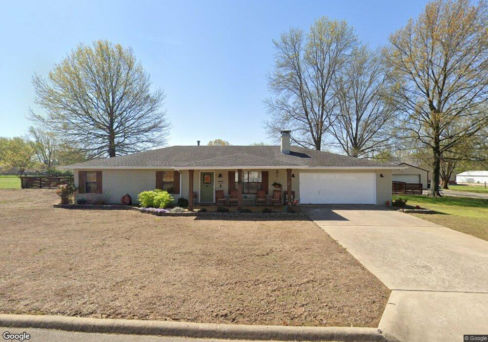
453 Kay St Farmington, AR 72730
Estimated Value: $348,998 - $399,000
--
Bed
2
Baths
2,142
Sq Ft
$175/Sq Ft
Est. Value
About This Home
This home is located at 453 Kay St, Farmington, AR 72730 and is currently estimated at $375,000, approximately $175 per square foot. 453 Kay St is a home located in Washington County with nearby schools including Randall G. Lynch Middle School, Jerry Pop Williams Elementary School, and Farmington Jr. High.
Ownership History
Date
Name
Owned For
Owner Type
Purchase Details
Closed on
Aug 1, 2017
Sold by
Cunningham Mark Anthony and Cunningham Brenda Lou
Bought by
Harmon Ricky and Harmon Tammy
Current Estimated Value
Home Financials for this Owner
Home Financials are based on the most recent Mortgage that was taken out on this home.
Original Mortgage
$180,000
Outstanding Balance
$151,990
Interest Rate
4.5%
Mortgage Type
Purchase Money Mortgage
Estimated Equity
$223,010
Purchase Details
Closed on
Dec 22, 2011
Sold by
Cunningham Leah and Cunningham Garrett L
Bought by
Cunningham Mark Anthony and Cunningham Brenda Lou
Purchase Details
Closed on
Jan 1, 1994
Bought by
Garrett Lw and Garrett Leah
Create a Home Valuation Report for This Property
The Home Valuation Report is an in-depth analysis detailing your home's value as well as a comparison with similar homes in the area
Home Values in the Area
Average Home Value in this Area
Purchase History
| Date | Buyer | Sale Price | Title Company |
|---|---|---|---|
| Harmon Ricky | $200,000 | Lenders Title Co | |
| Cunningham Mark Anthony | -- | None Available | |
| Garrett Lw | -- | -- |
Source: Public Records
Mortgage History
| Date | Status | Borrower | Loan Amount |
|---|---|---|---|
| Open | Harmon Ricky | $180,000 |
Source: Public Records
Tax History Compared to Growth
Tax History
| Year | Tax Paid | Tax Assessment Tax Assessment Total Assessment is a certain percentage of the fair market value that is determined by local assessors to be the total taxable value of land and additions on the property. | Land | Improvement |
|---|---|---|---|---|
| 2025 | $1,186 | $58,370 | $11,200 | $47,170 |
| 2024 | $1,304 | $58,370 | $11,200 | $47,170 |
| 2023 | $1,456 | $58,370 | $11,200 | $47,170 |
| 2022 | $1,506 | $41,450 | $8,000 | $33,450 |
| 2021 | $1,516 | $41,450 | $8,000 | $33,450 |
| 2020 | $1,516 | $41,450 | $8,000 | $33,450 |
| 2019 | $1,523 | $35,090 | $9,000 | $26,090 |
| 2018 | $1,548 | $35,090 | $9,000 | $26,090 |
| 2017 | $1,881 | $35,090 | $9,000 | $26,090 |
| 2016 | $840 | $35,090 | $9,000 | $26,090 |
| 2015 | $840 | $35,090 | $9,000 | $26,090 |
| 2014 | $840 | $22,210 | $4,800 | $17,410 |
Source: Public Records
Map
Nearby Homes
- 380 W Kinniburgh Dr
- 803 Rheas Mill Rd
- 530 Arizona St
- 0 W Main St Unit 1281343
- 0 W Main St Unit 1291778
- 0 W Main St Unit 1291878
- 574 Arizona St
- 578 Arizona St
- 114 W Main St
- 12849 Tyler Rd
- 179 Birchfield Ln
- Rye 1903 Plan at The Grove at Engles Mill
- Ouachita 1669 Plan at The Grove at Engles Mill
- Cache 1788 Plan at The Grove at Engles Mill
- Degray 1757 Plan at The Grove at Engles Mill
- Stella 1848 Plan at The Grove at Engles Mill
- Millwood 1862 Plan at The Grove at Engles Mill
- Magnolia 1556 Plan at The Grove at Engles Mill
- Eureka 1536 Plan at The Grove at Engles Mill
- Springs 1445 Plan at The Grove at Engles Mill