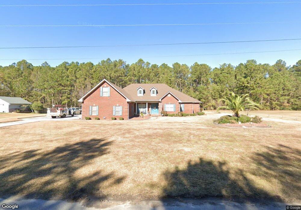
453 Main Trail Midway, GA 31320
Estimated Value: $346,000 - $478,000
4
Beds
5
Baths
3,847
Sq Ft
$114/Sq Ft
Est. Value
About This Home
This home is located at 453 Main Trail, Midway, GA 31320 and is currently estimated at $438,581, approximately $114 per square foot. 453 Main Trail is a home located in Liberty County with nearby schools including Joseph Martin Elementary School, Midway Middle School, and Liberty County High School.
Ownership History
Date
Name
Owned For
Owner Type
Purchase Details
Closed on
Dec 4, 2006
Sold by
Black Everette J
Bought by
Hemingway William and Hemingway Debbie D
Current Estimated Value
Purchase Details
Closed on
Aug 10, 2004
Sold by
Rogers Harry
Bought by
Black Everette J and Black Gabriele
Purchase Details
Closed on
Oct 2, 1996
Bought by
Rogers Harry
Create a Home Valuation Report for This Property
The Home Valuation Report is an in-depth analysis detailing your home's value as well as a comparison with similar homes in the area
Purchase History
| Date | Buyer | Sale Price | Title Company |
|---|---|---|---|
| Hemingway William | -- | -- | |
| Black Everette J | $18,500 | -- | |
| Rogers Harry | -- | -- |
Source: Public Records
Tax History
| Year | Tax Paid | Tax Assessment Tax Assessment Total Assessment is a certain percentage of the fair market value that is determined by local assessors to be the total taxable value of land and additions on the property. | Land | Improvement |
|---|---|---|---|---|
| 2024 | $2,164 | $165,651 | $11,400 | $154,251 |
| 2023 | $2,089 | $147,059 | $11,400 | $135,659 |
| 2022 | $894 | $121,824 | $11,400 | $110,424 |
| 2021 | $499 | $110,648 | $11,400 | $99,248 |
| 2020 | $972 | $111,761 | $11,400 | $100,361 |
| 2019 | $1,183 | $112,874 | $11,400 | $101,474 |
| 2018 | $1,384 | $114,013 | $11,400 | $102,613 |
| 2017 | $3,792 | $115,152 | $11,400 | $103,752 |
| 2016 | $1,630 | $116,290 | $11,400 | $104,890 |
| 2015 | $4,256 | $116,290 | $11,400 | $104,890 |
| 2014 | $4,256 | $122,451 | $11,400 | $111,051 |
| 2013 | -- | $118,431 | $14,000 | $104,431 |
Source: Public Records
Map
Nearby Homes
- 0 Main Trail Unit 10385280
- Lot 18 Main Trail
- 195 Wilkins Rd
- 435 Wilkins Rd
- 455 Tondee Way
- 590 Wilkins Rd
- 2022 Luke Rd
- 6.18 ACRES McIntosh Lake Rd
- 7337 E Oglethorpe Hwy
- 6228 E Oglethorpe Hwy
- 2.30 Highway 196 W
- TRACT 1 U S Highway 84 E
- 4620 E Oglethorpe Hwy
- 364 River Bend Dr
- 327 River Bend Dr
- 8701 E Oglethorpe Hwy
- 70 Pate Rogers Rd
- 776 Phillips Rd
- 35 W Red Fox Ct
- 99 E Deer Ct
- 493 Main Trail
- Lot 10 Main Trail Rd
- 0 Main Trail Unit SA218907
- Lot 20 Main Trail
- Lot 19 Main Trail
- 0 Main Trail Unit 107266
- 0 Main Trail Unit 110127
- 0 Main Trail Unit LOT 10,PH 2 3285737
- 10 Main Trail
- 0 Main Trail
- 405 Main Trail
- 405 Main Trail
- 515 Main Trail
- 510 Main Trail
- 70 Trail S
- 357 Main Trail
- 95 Trail S
- 71 Trail S
- 102 Trail Rd S
- 344 Main Trail
Your Personal Tour Guide
Ask me questions while you tour the home.