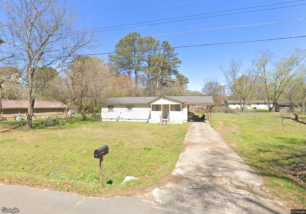
453 Mcarthur St Cedartown, GA 30125
Estimated Value: $171,000 - $236,000
3
Beds
2
Baths
1,580
Sq Ft
$128/Sq Ft
Est. Value
About This Home
This home is located at 453 Mcarthur St, Cedartown, GA 30125 and is currently estimated at $202,820, approximately $128 per square foot. 453 Mcarthur St is a home located in Polk County with nearby schools including Cedar Christian School.
Ownership History
Date
Name
Owned For
Owner Type
Purchase Details
Closed on
Aug 24, 2006
Sold by
Wells Fargo
Bought by
Gurnan Ididra
Current Estimated Value
Purchase Details
Closed on
May 2, 2006
Sold by
Abraham Monroe
Bought by
Wells Fargo Bank
Purchase Details
Closed on
Apr 19, 1984
Sold by
Hall Nellie A
Bought by
Monroe Abraham
Purchase Details
Closed on
Apr 2, 1984
Bought by
Hall Nellie A
Purchase Details
Closed on
Dec 11, 1982
Sold by
Benton Linda L
Bought by
Hall Nellie A
Purchase Details
Closed on
Jul 22, 1981
Sold by
Smith Connie and Smith
Bought by
Benton Linda L
Purchase Details
Closed on
Apr 18, 1980
Sold by
Smith Linda Marie
Bought by
Smith Connie and Smith
Purchase Details
Closed on
Jul 21, 1971
Sold by
Croker James B
Bought by
Smith Linda Marie
Purchase Details
Closed on
May 5, 1970
Bought by
Croker James B
Create a Home Valuation Report for This Property
The Home Valuation Report is an in-depth analysis detailing your home's value as well as a comparison with similar homes in the area
Home Values in the Area
Average Home Value in this Area
Purchase History
| Date | Buyer | Sale Price | Title Company |
|---|---|---|---|
| Gurnan Ididra | $51,000 | -- | |
| Wells Fargo Bank | $51,150 | -- | |
| Monroe Abraham | -- | -- | |
| Hall Nellie A | -- | -- | |
| Hall Nellie A | -- | -- | |
| Benton Linda L | -- | -- | |
| Benton Linda L | -- | -- | |
| Smith Connie | -- | -- | |
| Smith Linda Marie | -- | -- | |
| Croker James B | -- | -- |
Source: Public Records
Tax History Compared to Growth
Tax History
| Year | Tax Paid | Tax Assessment Tax Assessment Total Assessment is a certain percentage of the fair market value that is determined by local assessors to be the total taxable value of land and additions on the property. | Land | Improvement |
|---|---|---|---|---|
| 2024 | $886 | $42,401 | $2,200 | $40,201 |
| 2023 | $720 | $30,320 | $880 | $29,440 |
| 2022 | $616 | $25,949 | $880 | $25,069 |
| 2021 | $624 | $25,949 | $880 | $25,069 |
| 2020 | $625 | $25,949 | $880 | $25,069 |
| 2019 | $521 | $19,412 | $1,713 | $17,699 |
| 2018 | $512 | $18,598 | $1,468 | $17,130 |
| 2017 | $506 | $18,598 | $1,468 | $17,130 |
| 2016 | $506 | $18,598 | $1,468 | $17,130 |
| 2015 | $512 | $18,775 | $1,468 | $17,307 |
| 2014 | $541 | $19,684 | $1,713 | $17,972 |
Source: Public Records
Map
Nearby Homes
- 618 Valley Rd
- 645 Valley Rd
- 662 Hillside Dr
- 660 Valley Rd
- 10 Woodglen Dr
- 1101 East Ave
- 202 Ridgewood Rd
- 209 Ridgewood Rd
- 109 Perry St
- 77 Ben Dr W
- 12 Breckenridge Dr
- 292 Kimwood Dr
- 362 Oakwood Dr
- 254 E Girard Ave
- 256 Cuzzort Rd
- 0 Blanche Rd Unit 10609468
- 0 Blanche Rd Unit 7652978
- 462 Oakwood Dr
- 00 Juliette St
- 537 Fletcher St