Estimated Value: $489,000 - $498,000
3
Beds
2
Baths
2,080
Sq Ft
$237/Sq Ft
Est. Value
About This Home
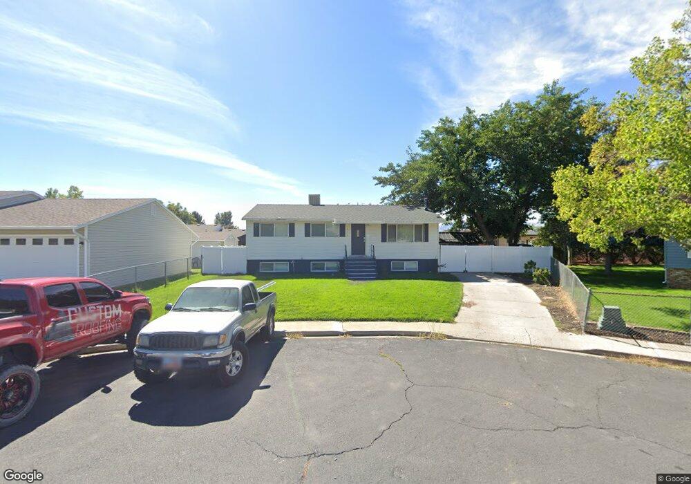
This home is located at 453 W 1750 N, Lehi, UT 84043 and is currently estimated at $493,294, approximately $237 per square foot. 453 W 1750 N is a home located in Utah County with nearby schools including Eaglecrest Elementary School, Lehi Junior High School, and Skyridge High School.
Ownership History
Date
Name
Owned For
Owner Type
Purchase Details
Closed on
Aug 29, 2018
Sold by
Sorenson Paul Owen
Bought by
Reeves Kelly Shane
Current Estimated Value
Home Financials for this Owner
Home Financials are based on the most recent Mortgage that was taken out on this home.
Original Mortgage
$233,985
Outstanding Balance
$203,628
Interest Rate
4.5%
Mortgage Type
New Conventional
Estimated Equity
$289,666
Purchase Details
Closed on
Jul 13, 2008
Sold by
Sorenson Paul and Sorenson Charlet
Bought by
Sorenson Paul Owen
Home Financials for this Owner
Home Financials are based on the most recent Mortgage that was taken out on this home.
Original Mortgage
$173,565
Interest Rate
6.31%
Mortgage Type
New Conventional
Purchase Details
Closed on
Feb 23, 2007
Sold by
Sorenson Paul Owen
Bought by
Sorenson Paul and Sorenson Charlet
Home Financials for this Owner
Home Financials are based on the most recent Mortgage that was taken out on this home.
Original Mortgage
$159,355
Interest Rate
6.21%
Mortgage Type
New Conventional
Purchase Details
Closed on
Mar 21, 2005
Sold by
Sorenson Paul and Sorenson Charlet
Bought by
Sorenson Paul and Sorenson Charlet
Home Financials for this Owner
Home Financials are based on the most recent Mortgage that was taken out on this home.
Original Mortgage
$128,700
Interest Rate
7.49%
Mortgage Type
New Conventional
Purchase Details
Closed on
Mar 30, 2004
Sold by
Belnap David Paul and Belnap Rebecca A
Bought by
Sorenson Paul and Sorenson Charlet
Home Financials for this Owner
Home Financials are based on the most recent Mortgage that was taken out on this home.
Original Mortgage
$122,862
Interest Rate
5.57%
Mortgage Type
Seller Take Back
Purchase Details
Closed on
Feb 21, 2001
Sold by
Contimortgage Corp
Bought by
Belnap David and Belnap Rebecca
Purchase Details
Closed on
Jul 30, 1998
Sold by
Sawyer Michael D and Sawyer Lee Ann
Bought by
Belnap David Paul and Belnap Rebecca A
Create a Home Valuation Report for This Property
The Home Valuation Report is an in-depth analysis detailing your home's value as well as a comparison with similar homes in the area
Home Values in the Area
Average Home Value in this Area
Purchase History
| Date | Buyer | Sale Price | Title Company |
|---|---|---|---|
| Reeves Kelly Shane | -- | Us Title Insurance Agency | |
| Sorenson Paul Owen | -- | Meridian Title Company | |
| Sorenson Paul | -- | Meridian Title Company | |
| Sorenson Paul Owen | -- | Meridian Title Company | |
| Sorenson Paul | -- | Horizon Title Insurance | |
| Sorenson Paul | -- | Equity Title Orem Blvd | |
| Belnap David | -- | First American Title Co | |
| Belnap David Paul | -- | -- |
Source: Public Records
Mortgage History
| Date | Status | Borrower | Loan Amount |
|---|---|---|---|
| Open | Reeves Kelly Shane | $233,985 | |
| Previous Owner | Sorenson Paul Owen | $173,565 | |
| Previous Owner | Sorenson Paul Owen | $159,355 | |
| Previous Owner | Sorenson Paul | $128,700 | |
| Previous Owner | Sorenson Paul | $122,862 |
Source: Public Records
Tax History Compared to Growth
Tax History
| Year | Tax Paid | Tax Assessment Tax Assessment Total Assessment is a certain percentage of the fair market value that is determined by local assessors to be the total taxable value of land and additions on the property. | Land | Improvement |
|---|---|---|---|---|
| 2025 | $1,865 | $249,315 | $178,400 | $274,900 |
| 2024 | $1,865 | $218,240 | $0 | $0 |
| 2023 | $1,708 | $217,030 | $0 | $0 |
| 2022 | $1,831 | $225,500 | $0 | $0 |
| 2021 | $1,626 | $302,800 | $103,200 | $199,600 |
| 2020 | $1,532 | $282,100 | $95,600 | $186,500 |
| 2019 | $1,347 | $257,800 | $95,600 | $162,200 |
| 2018 | $1,272 | $230,100 | $87,200 | $142,900 |
| 2017 | $1,165 | $112,035 | $0 | $0 |
| 2016 | $1,148 | $102,410 | $0 | $0 |
| 2015 | $1,064 | $90,090 | $0 | $0 |
| 2014 | $996 | $83,875 | $0 | $0 |
Source: Public Records
Map
Nearby Homes
- 1755 N 250 W
- 1817 W Bad Rock Cir
- 497 W 2200 N
- 595 W 2200 N
- 902 W 1500 N
- 4333 N Baiken Ridge Dr Unit 1020
- 497 W 2280 N
- 1011 W Mountain Way Unit 316
- 1329 N 100 E Unit 21
- 1150 N 200 W Unit 6
- 1301 N 900 W Unit 12
- 2287 N 750 W
- 1610 N 1125 W
- 1295 N 190 E
- 1094 W 1425 N
- 996 N 200 W
- 192 E 2200 N
- 155 W State St Unit TRLR 3
- 1272 W 1800 N
- 68 W State St