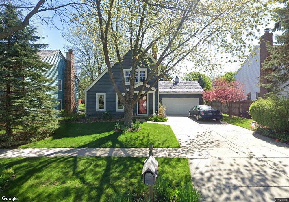
4532 Kings Way N Gurnee, IL 60031
Estimated Value: $365,309 - $389,000
3
Beds
2
Baths
1,248
Sq Ft
$302/Sq Ft
Est. Value
About This Home
This home is located at 4532 Kings Way N, Gurnee, IL 60031 and is currently estimated at $376,827, approximately $301 per square foot. 4532 Kings Way N is a home located in Lake County with nearby schools including Woodland Primary School, Woodland Intermediate School, and Woodland Elementary School.
Ownership History
Date
Name
Owned For
Owner Type
Purchase Details
Closed on
Mar 2, 1996
Sold by
Fox Peter N and Fox Susan K
Bought by
Depino David P and Depino Lisa L
Current Estimated Value
Home Financials for this Owner
Home Financials are based on the most recent Mortgage that was taken out on this home.
Original Mortgage
$140,000
Interest Rate
8.1%
Mortgage Type
Balloon
Create a Home Valuation Report for This Property
The Home Valuation Report is an in-depth analysis detailing your home's value as well as a comparison with similar homes in the area
Home Values in the Area
Average Home Value in this Area
Purchase History
| Date | Buyer | Sale Price | Title Company |
|---|---|---|---|
| Depino David P | $175,000 | -- |
Source: Public Records
Mortgage History
| Date | Status | Borrower | Loan Amount |
|---|---|---|---|
| Previous Owner | Depino David P | $140,000 |
Source: Public Records
Tax History
| Year | Tax Paid | Tax Assessment Tax Assessment Total Assessment is a certain percentage of the fair market value that is determined by local assessors to be the total taxable value of land and additions on the property. | Land | Improvement |
|---|---|---|---|---|
| 2024 | $8,339 | $101,526 | $27,295 | $74,231 |
| 2023 | $7,702 | $91,513 | $24,603 | $66,910 |
| 2022 | $7,702 | $83,742 | $21,511 | $62,231 |
| 2021 | $6,961 | $80,382 | $20,648 | $59,734 |
| 2020 | $6,732 | $78,406 | $20,140 | $58,266 |
| 2019 | $6,536 | $76,129 | $19,555 | $56,574 |
| 2018 | $6,482 | $76,505 | $21,978 | $54,527 |
| 2017 | $6,410 | $74,313 | $21,348 | $52,965 |
| 2016 | $6,350 | $71,004 | $20,397 | $50,607 |
| 2015 | $6,178 | $67,341 | $19,345 | $47,996 |
| 2014 | $5,963 | $65,609 | $19,068 | $46,541 |
| 2012 | $5,657 | $66,111 | $19,214 | $46,897 |
Source: Public Records
Map
Nearby Homes
- 33718 N Oplaine Rd
- 468 Tanglewood Dr
- 450 Tanglewood Dr
- 387 Long Hill Rd
- 134 Heritage Ct Unit B
- 287 Kensington Ct Unit 4
- 546 Thorndale Ave
- 4437-4495 W Kennedy Dr
- 4185 Eastwood Place
- 33564 Greenleaf St
- 4520 W Lawn Ave
- 4232 Kenwood Ave
- 968 S Darla Ct
- 3861 Sutherland Dr
- 4447 W Lawn Ave
- 4390 W Parkway Ave
- 4481 W Tucker Ln
- 3810 1st St
- 1102 S Oplaine Rd
- 1251 S Pleasant Hill Gate Unit 21
- 4524 Kings Way N
- 4540 Kings Way N
- 331 Mayflower Ct
- 4516 Kings Way N
- 313 Mayflower Ct
- 4547 Kings Way N
- 4508 Kings Way N
- 4521 Kings Way N
- 376 Briarwood Ct
- 4548 Covenant Ct
- 295 Mayflower Ct
- 4555 Kings Way N
- 316 Mayflower Ct
- 352 Briarwood Ct
- 398 Briarwood Ct
- 277 Mayflower Ct
- 4556 Covenant Ct
- 301 S Oplaine Rd
- 003 O'Plaine Rd
- LT 9 & 10 O'Plaine Rd
Your Personal Tour Guide
Ask me questions while you tour the home.