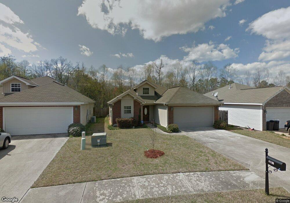
4538 Smithfield Dr Northport, AL 35473
Estimated Value: $227,000 - $261,000
3
Beds
2
Baths
1,383
Sq Ft
$180/Sq Ft
Est. Value
About This Home
This home is located at 4538 Smithfield Dr, Northport, AL 35473 and is currently estimated at $248,786, approximately $179 per square foot. 4538 Smithfield Dr is a home located in Tuscaloosa County with nearby schools including Crestmont Elementary School, Echols Middle School, and Tuscaloosa County High School.
Ownership History
Date
Name
Owned For
Owner Type
Purchase Details
Closed on
Mar 19, 2012
Sold by
Santoro John E
Bought by
Santoro John E
Current Estimated Value
Purchase Details
Closed on
Sep 14, 2009
Sold by
Santoro John E
Bought by
Santoro John E
Purchase Details
Closed on
Mar 1, 2006
Sold by
Mcjenkin Tom
Bought by
Santoro John E
Home Financials for this Owner
Home Financials are based on the most recent Mortgage that was taken out on this home.
Original Mortgage
$115,250
Interest Rate
6.05%
Mortgage Type
Purchase Money Mortgage
Create a Home Valuation Report for This Property
The Home Valuation Report is an in-depth analysis detailing your home's value as well as a comparison with similar homes in the area
Home Values in the Area
Average Home Value in this Area
Purchase History
| Date | Buyer | Sale Price | Title Company |
|---|---|---|---|
| Santoro John E | $29,000 | -- | |
| Santoro John E | $29,000 | -- | |
| Santoro John E | $144,250 | -- |
Source: Public Records
Mortgage History
| Date | Status | Borrower | Loan Amount |
|---|---|---|---|
| Previous Owner | Santoro John E | $115,250 |
Source: Public Records
Tax History Compared to Growth
Tax History
| Year | Tax Paid | Tax Assessment Tax Assessment Total Assessment is a certain percentage of the fair market value that is determined by local assessors to be the total taxable value of land and additions on the property. | Land | Improvement |
|---|---|---|---|---|
| 2024 | $703 | $38,940 | $6,000 | $32,940 |
| 2023 | $703 | $39,340 | $6,000 | $33,340 |
| 2022 | $1,461 | $37,940 | $6,000 | $31,940 |
| 2021 | $668 | $34,700 | $6,000 | $28,700 |
| 2020 | $649 | $33,720 | $6,000 | $27,720 |
| 2019 | $584 | $30,320 | $6,000 | $24,320 |
| 2018 | $614 | $31,880 | $6,000 | $25,880 |
| 2017 | $1,054 | $0 | $0 | $0 |
| 2016 | $1,050 | $0 | $0 | $0 |
| 2015 | -- | $0 | $0 | $0 |
| 2014 | -- | $27,280 | $6,000 | $21,280 |
Source: Public Records
Map
Nearby Homes
- 4801 Boh Ave
- 4922 Allums Ave
- 5120 Stewart Parc Dr
- 4531 White Dogwood Ln
- 5118 Azalea Trail
- 5211 Briarcliff Dr
- 5206 Azalea Trail
- 5203 Candlewood Dr
- 4600 Oak Way
- 4605 Oak Way
- 4810 Oak Way
- 4007 Savanah St
- 4115 Malvern Hill Dr
- 5204 Applewood Dr
- 4517 Bluestem Ln
- 5100 Oak Way
- 0 Tulip Tree Ln
- 3917 Magnolia Hills Dr
- 3906 Silver Maple Dr
- 3908 Magnolia Hills Dr
- 4544 Smithfield Dr
- 4532 Smithfield Dr
- 4602 Smithfield Dr
- 4526 Smithfield Dr
- 4520 Smithfield Dr
- 4608 Smithfield Dr
- 4537 Smithfield Dr
- 4531 Smithfield Dr
- 4614 Smithfield Dr
- 4543 Smithfield Dr
- 4620 Smithfield Dr
- 4609 Smithfield Dr
- 4615 Smithfield Dr
- 4850 Smithfield Blvd
- 4844 Smithfield Blvd
- 4621 Smithfield Dr
- 4627 Smithfield Dr
- 5017 Smithfield Cir
- 5023 Smithfield Cir
- 4633 Smithfield Dr