Estimated Value: $534,435 - $611,000
--
Bed
--
Bath
672
Sq Ft
$845/Sq Ft
Est. Value
About This Home
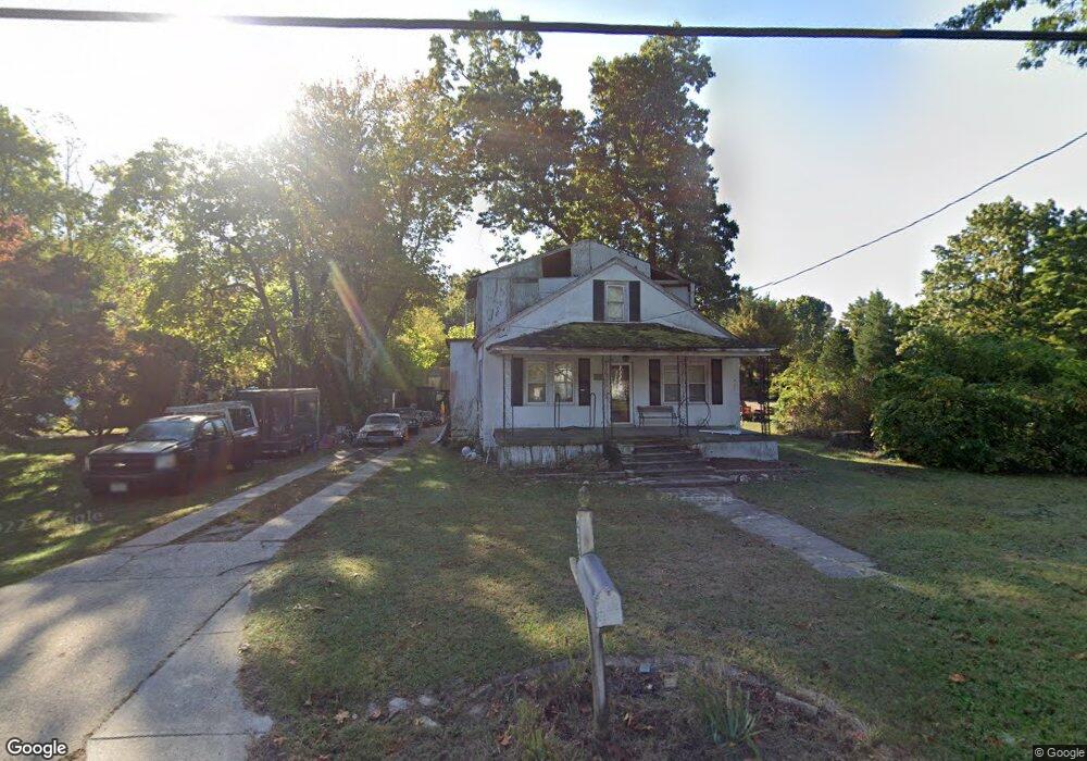
This home is located at 454 Atco Ave, Atco, NJ 08004 and is currently estimated at $567,609, approximately $844 per square foot. 454 Atco Ave is a home located in Camden County with nearby schools including Thomas Richards Elementary School, Waterford Elementary School, and Atco Elementary School.
Ownership History
Date
Name
Owned For
Owner Type
Purchase Details
Closed on
May 20, 2020
Sold by
Coulter George R
Bought by
Gazzara Matthew Robert and Haistead Angela Lynn
Current Estimated Value
Home Financials for this Owner
Home Financials are based on the most recent Mortgage that was taken out on this home.
Original Mortgage
$308,750
Outstanding Balance
$273,078
Interest Rate
3.2%
Mortgage Type
New Conventional
Estimated Equity
$294,531
Purchase Details
Closed on
Jun 28, 2018
Sold by
Lange William Norman
Bought by
Coulter George R
Create a Home Valuation Report for This Property
The Home Valuation Report is an in-depth analysis detailing your home's value as well as a comparison with similar homes in the area
Home Values in the Area
Average Home Value in this Area
Purchase History
| Date | Buyer | Sale Price | Title Company |
|---|---|---|---|
| Gazzara Matthew Robert | $325,000 | Surety Title Company | |
| Coulter George R | $10,000 | Mortgage Lenders Svcs |
Source: Public Records
Mortgage History
| Date | Status | Borrower | Loan Amount |
|---|---|---|---|
| Open | Gazzara Matthew Robert | $308,750 |
Source: Public Records
Tax History Compared to Growth
Tax History
| Year | Tax Paid | Tax Assessment Tax Assessment Total Assessment is a certain percentage of the fair market value that is determined by local assessors to be the total taxable value of land and additions on the property. | Land | Improvement |
|---|---|---|---|---|
| 2025 | $11,610 | $263,500 | $42,800 | $220,700 |
| 2024 | $11,323 | $263,500 | $42,800 | $220,700 |
| 2023 | $11,323 | $263,500 | $42,800 | $220,700 |
| 2022 | $10,819 | $263,500 | $42,800 | $220,700 |
| 2021 | $10,767 | $263,500 | $42,800 | $220,700 |
| 2020 | $1,740 | $42,800 | $42,800 | $0 |
| 2019 | $1,714 | $42,800 | $42,800 | $0 |
| 2018 | $4,108 | $102,700 | $42,800 | $59,900 |
| 2017 | $4,044 | $102,700 | $42,800 | $59,900 |
| 2016 | $3,986 | $102,700 | $42,800 | $59,900 |
| 2015 | $3,881 | $102,700 | $42,800 | $59,900 |
| 2014 | $4,082 | $73,900 | $29,300 | $44,600 |
Source: Public Records
Map
Nearby Homes
- 465 Atco Ave
- 411 Atco Ave
- 348 White Horse Pike
- 2107 Cooper Rd
- 326 White Horse Pike
- 4 Bromley Ct
- 295 White Horse Pike
- 21 Cornell Rd
- 2157 Almira Ave
- 8 Hunters Ct
- 21 Briarcliff Rd
- 275 White Horse Pike
- 2148 Bartram Ave
- 16 Brookview Dr
- 252 Hayes Mill Rd
- 2297 Memorial Ct
- 286 Front St
- 24 Deer Pond Blvd
- 344 Raritan Ave
- 2480 Gerald Ct