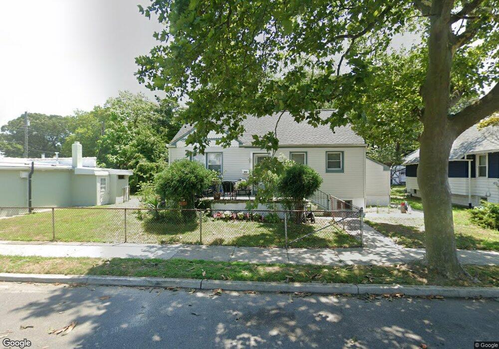
454 Atlantic Ave Somers Point, NJ 08244
Estimated Value: $430,321 - $491,000
--
Bed
--
Bath
1,972
Sq Ft
$236/Sq Ft
Est. Value
About This Home
This home is located at 454 Atlantic Ave, Somers Point, NJ 08244 and is currently estimated at $466,330, approximately $236 per square foot. 454 Atlantic Ave is a home located in Atlantic County with nearby schools including Mainland Regional High School, ChARTer TECH High School for the Performing Arts, and Saint Joseph Regional School.
Ownership History
Date
Name
Owned For
Owner Type
Purchase Details
Closed on
Sep 29, 2005
Sold by
Cruz Kelly
Bought by
Timothy Mcbride
Current Estimated Value
Home Financials for this Owner
Home Financials are based on the most recent Mortgage that was taken out on this home.
Original Mortgage
$245,000
Outstanding Balance
$131,548
Interest Rate
5.81%
Mortgage Type
Purchase Money Mortgage
Estimated Equity
$334,782
Purchase Details
Closed on
Nov 21, 1994
Sold by
Mclaughlin James J
Bought by
Mclaughlin Cruz Kelly
Create a Home Valuation Report for This Property
The Home Valuation Report is an in-depth analysis detailing your home's value as well as a comparison with similar homes in the area
Home Values in the Area
Average Home Value in this Area
Purchase History
| Date | Buyer | Sale Price | Title Company |
|---|---|---|---|
| Timothy Mcbride | $325,000 | -- | |
| Mclaughlin Cruz Kelly | -- | -- |
Source: Public Records
Mortgage History
| Date | Status | Borrower | Loan Amount |
|---|---|---|---|
| Open | Timothy Mcbride | $245,000 |
Source: Public Records
Tax History Compared to Growth
Tax History
| Year | Tax Paid | Tax Assessment Tax Assessment Total Assessment is a certain percentage of the fair market value that is determined by local assessors to be the total taxable value of land and additions on the property. | Land | Improvement |
|---|---|---|---|---|
| 2025 | $8,539 | $238,800 | $65,900 | $172,900 |
| 2024 | $8,539 | $238,800 | $65,900 | $172,900 |
| 2023 | $7,978 | $238,800 | $65,900 | $172,900 |
| 2022 | $7,978 | $238,800 | $65,900 | $172,900 |
| 2021 | $7,859 | $238,800 | $65,900 | $172,900 |
| 2020 | $7,699 | $238,800 | $65,900 | $172,900 |
| 2019 | $7,482 | $238,800 | $65,900 | $172,900 |
| 2018 | $7,324 | $238,800 | $65,900 | $172,900 |
| 2017 | $7,061 | $238,800 | $65,900 | $172,900 |
| 2016 | $6,741 | $238,800 | $65,900 | $172,900 |
| 2015 | $6,672 | $238,800 | $65,900 | $172,900 |
| 2014 | $6,448 | $238,800 | $65,900 | $172,900 |
Source: Public Records
Map
Nearby Homes
- 421 Shore Rd
- 137 W Johnson Ave
- 25 W Pierson Ave
- 109 E Cedar Ave
- 101 E Johnson Ave
- 1102 Jesse Dr
- 2102 Angelina Ln
- 1020 Pleasant Ave
- 1013 Pleasant Ave
- 1014 Pleasant Ave
- 1024 Pleasant Ave
- 1015 Pleasant Ave
- 123 E Cedar Ave
- 29 E Pierson Ave
- 112 E Pierson Ave
- 114 E Pierson Ave
- 1002 Pleasant Ave
- 303 Garden Terrace
- 1803 Pleasant Ave
- 33 W Meyran Ave
- 28 W Groveland Ave
- 458 Atlantic Ave
- 24 E Groveland Ave
- 24 W Groveland Ave
- 27 W Maryland Ave
- 25 W Groveland Ave
- 20 W Groveland Ave
- 427 1st St Unit 427
- 425 1st St
- 428 Atlantic Ave
- 21 W Maryland Ave
- 23 W Groveland Ave
- 14 W Groveland Ave
- 17 W Maryland Ave
- 455 1st St
- 418 Atlantic Ave
- 15 W Groveland Ave
- 15 W Maryland Ave
- 459 1st St
- 431 1st St Unit 431