
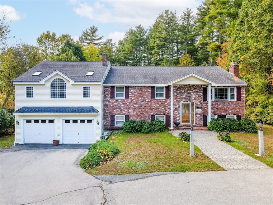
454 Dunstable Rd Tyngsboro, MA 01879
Estimated payment $4,957/month
Total Views
1,386
3
Beds
3
Baths
3,764
Sq Ft
$213
Price per Sq Ft
Highlights
- Hot Property
- Landscaped Professionally
- Cathedral Ceiling
- Medical Services
- Fireplace in Primary Bedroom
- Wood Flooring
About This Home
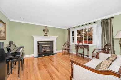
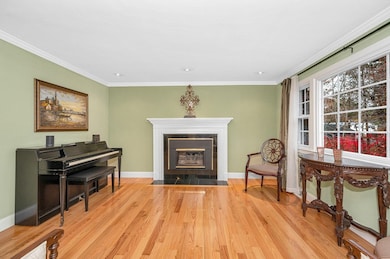
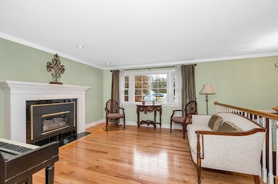
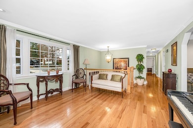
Welcome to 454 Dunstable Road, a stunning and meticulously maintained split-level home offering the perfect blend of comfort, space, and modern convenience. Situated on a level one-acre lot, this beautiful property features ten rooms, a three-bedroom septic system, and three full bathrooms. Step inside to find gleaming hardwood floors, freshly painted interiors, and an abundance of natural light throughout. The open and flexible floor plan provides plenty of room for both entertaining and everyday living. The massive master suite is a true retreat with vaulted ceilings, a private en suite bath, and generous closet space. Enjoy the added convenience of a pellet stove for supplemental heat along with forced hot air heating and central air conditioning for year round comfort. This home also includes a residential elevator adding ease of access and convenience for all. The flat landscaped acre offers ample space for recreation, gardening, or future expansion. O/H 11/15 1-3pm 11/16 & 11-1pm
Open House Schedule
-
Saturday, November 15, 20251:00 to 3:00 pm11/15/2025 1:00:00 PM +00:0011/15/2025 3:00:00 PM +00:00Join us at our new listing on Saturday from 1-3pm for our Open house!Add to Calendar
-
Sunday, November 16, 202511:00 am to 1:00 pm11/16/2025 11:00:00 AM +00:0011/16/2025 1:00:00 PM +00:00Join us on Sunday from 11-1pm for our Open House.Add to Calendar
Home Details
Home Type
- Single Family
Est. Annual Taxes
- $8,896
Year Built
- Built in 1974
Lot Details
- 1 Acre Lot
- Landscaped Professionally
- Sprinkler System
- Property is zoned R1
Parking
- 2 Car Attached Garage
- Tuck Under Parking
- Oversized Parking
- Parking Storage or Cabinetry
- Garage Door Opener
- Driveway
- Open Parking
- Off-Street Parking
Home Design
- Split Level Home
- Frame Construction
- Asphalt Roof
- Concrete Perimeter Foundation
Interior Spaces
- Wet Bar
- Central Vacuum
- Cathedral Ceiling
- Skylights
- Recessed Lighting
- Decorative Lighting
- Light Fixtures
- Insulated Windows
- Bay Window
- Sliding Doors
- Insulated Doors
- Living Room with Fireplace
- Home Office
- Bonus Room
- Game Room
- Screened Porch
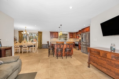
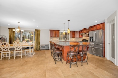
Kitchen
- Stove
- Range
- Microwave
- Dishwasher
- Wine Refrigerator
- Stainless Steel Appliances
- Kitchen Island
- Solid Surface Countertops
- Disposal
Flooring
- Wood
- Wall to Wall Carpet
- Ceramic Tile
Bedrooms and Bathrooms
- 3 Bedrooms
- Fireplace in Primary Bedroom
- Primary bedroom located on second floor
- Cedar Closet
- Walk-In Closet
- 3 Full Bathrooms
- Double Vanity
- Soaking Tub
- Bathtub Includes Tile Surround
- Separate Shower
- Linen Closet In Bathroom
Laundry
- Laundry on main level
- Dryer
- Washer
- Sink Near Laundry
Finished Basement
- Basement Fills Entire Space Under The House
- Interior Basement Entry
- Garage Access
Accessible Home Design
- Handicap Accessible
- Level Entry For Accessibility
Outdoor Features
- Outdoor Storage
- Rain Gutters
Location
- Property is near schools
Utilities
- Two cooling system units
- Forced Air Heating and Cooling System
- 2 Cooling Zones
- 2 Heating Zones
- Heating System Uses Natural Gas
- Pellet Stove burns compressed wood to generate heat
- 200+ Amp Service
- Tankless Water Heater
- Private Sewer
- High Speed Internet
Listing and Financial Details
- Assessor Parcel Number M:015 B:0068 L:0,810023
Community Details
Overview
- No Home Owners Association
Amenities
- Medical Services
- Shops
- Coin Laundry
Recreation
- Jogging Path
Map
Create a Home Valuation Report for This Property
The Home Valuation Report is an in-depth analysis detailing your home's value as well as a comparison with similar homes in the area
Home Values in the Area
Average Home Value in this Area
Tax History
| Year | Tax Paid | Tax Assessment Tax Assessment Total Assessment is a certain percentage of the fair market value that is determined by local assessors to be the total taxable value of land and additions on the property. | Land | Improvement |
|---|---|---|---|---|
| 2025 | $8,896 | $720,900 | $230,900 | $490,000 |
| 2024 | $8,667 | $681,400 | $220,000 | $461,400 |
| 2023 | $8,244 | $583,000 | $183,000 | $400,000 |
| 2022 | $7,881 | $527,500 | $159,000 | $368,500 |
| 2021 | $7,763 | $483,100 | $143,700 | $339,400 |
| 2020 | $7,542 | $464,100 | $143,700 | $320,400 |
| 2019 | $7,288 | $430,500 | $137,200 | $293,300 |
| 2018 | $1,710 | $414,200 | $137,200 | $277,000 |
| 2017 | $6,710 | $391,000 | $137,200 | $253,800 |
| 2016 | $6,042 | $344,100 | $115,400 | $228,700 |
| 2015 | $5,836 | $344,100 | $115,400 | $228,700 |
Source: Public Records
Property History
| Date | Event | Price | List to Sale | Price per Sq Ft |
|---|---|---|---|---|
| 11/12/2025 11/12/25 | For Sale | $799,900 | -- | $213 / Sq Ft |
Source: MLS Property Information Network (MLS PIN)
Purchase History
| Date | Type | Sale Price | Title Company |
|---|---|---|---|
| Deed | $240,000 | -- |
Source: Public Records
Mortgage History
| Date | Status | Loan Amount | Loan Type |
|---|---|---|---|
| Open | $160,000 | No Value Available | |
| Closed | $140,000 | Purchase Money Mortgage | |
| Previous Owner | $76,200 | No Value Available | |
| Previous Owner | $137,200 | No Value Available |
Source: Public Records
About the Listing Agent
CEO Of the Espinola Group Powered By Keller Williams Realty Merrimack Valley
Dynamic and Accomplished Professional Real Estate Agent with over 20 Years of Experience in the Industry. Kelly Espinola maintains a Proven Track Record of Closing Business, Working Effectively with all Transaction Stakeholders, and Developing and Upholding Long-Term Relationships. Specialize in both Residential and Commercial Real Estate transactions where she is able to Generate Business through aggressive
Kelly's Other Listings
Source: MLS Property Information Network (MLS PIN)
MLS Number: 73454267
APN: TYNG-000015-000068
Disclaimer: Certain information contained herein is derived from information provided by parties other than Homes.com. All information provided is deemed reliable, but is not guaranteed to be accurate and should be independently verified.
![]() The property listing data and information, or the Images, set forth herein were provided to MLS Property Information Network, Inc. from third party sources, including sellers, lessors and public records, and were compiled by MLS Property Information Network, Inc. The property listing data and information, and the Images, are for the personal, non-commercial use of consumers having a good faith interest in purchasing or leasing listed properties of the type displayed to them and may not be used for any purpose other than to identify prospective properties which such consumers may have a good faith interest in purchasing or leasing. MLS Property Information Network, Inc. and its subscribers disclaim any and all representations and warranties as to the accuracy of the property listing data and information, or as to the accuracy of any of the Images, set forth herein.
The property listing data and information, or the Images, set forth herein were provided to MLS Property Information Network, Inc. from third party sources, including sellers, lessors and public records, and were compiled by MLS Property Information Network, Inc. The property listing data and information, and the Images, are for the personal, non-commercial use of consumers having a good faith interest in purchasing or leasing listed properties of the type displayed to them and may not be used for any purpose other than to identify prospective properties which such consumers may have a good faith interest in purchasing or leasing. MLS Property Information Network, Inc. and its subscribers disclaim any and all representations and warranties as to the accuracy of the property listing data and information, or as to the accuracy of any of the Images, set forth herein.
Nearby Homes
- 7 Axletree Rd
- 17 Cannongate Rd Unit 87
- 45 Red Gate Rd
- 0 Dunstable Rd
- 10 Dickens Ln
- 0 Lowell St
- 76 Russells Way
- 23 Morrison Ln
- 19 Sandstone Rd
- 24 Old Tyng Rd
- 20 Highland Rd
- 15 Stone Ridge Rd
- 46 Pawtucket Blvd Unit 38
- 22 Highland Rd
- 52 Pawtucket Blvd Unit 21
- 20 Merrimac Way Unit 20E
- 45 Riley Rd Unit 45
- 28 Juniper Ln Unit 65
- 11 Juniper Ln Unit 14
- 56 Frost Rd
- 5 Westford Rd Unit 1
- 58 Pumpkin Cir Unit 58
- 2 Village Ln
- 21 Merrimac Way
- 23 Fox Run Unit 57
- 5 Mission Rd Unit 101
- 134 Tyngsboro Rd Unit 10
- 132 Tyngsboro Rd Unit 1
- 9 Strawberry Bank Rd
- 25 Bay Ridge Dr
- 9 Silver Dr
- 3 Sapling Cir
- 21 Spit Brook Rd
- 64 Kennedy Dr Unit 64
- 73 Kennedy Dr
- 1219 Pawtucket Blvd Unit 75
- 1 Newcastle Dr
- 16 Quigley Ave Unit 16
- 37 Cadogan Way Unit UR216
- 8 Digital Dr