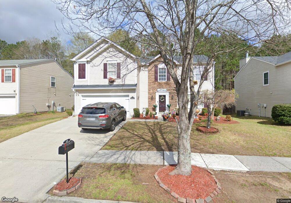
454 Leaflet Ives Dr Unit 1 Lawrenceville, GA 30045
Estimated Value: $365,000 - $402,000
4
Beds
3
Baths
2,332
Sq Ft
$162/Sq Ft
Est. Value
About This Home
This home is located at 454 Leaflet Ives Dr Unit 1, Lawrenceville, GA 30045 and is currently estimated at $378,190, approximately $162 per square foot. 454 Leaflet Ives Dr Unit 1 is a home located in Gwinnett County with nearby schools including W.J. Cooper Elementary School, McConnell Middle School, and Archer High School.
Ownership History
Date
Name
Owned For
Owner Type
Purchase Details
Closed on
Sep 28, 2007
Sold by
Woodside Properties Ltd
Bought by
Thomas Dionne
Current Estimated Value
Home Financials for this Owner
Home Financials are based on the most recent Mortgage that was taken out on this home.
Original Mortgage
$171,000
Outstanding Balance
$107,324
Interest Rate
6.49%
Mortgage Type
New Conventional
Estimated Equity
$270,866
Create a Home Valuation Report for This Property
The Home Valuation Report is an in-depth analysis detailing your home's value as well as a comparison with similar homes in the area
Home Values in the Area
Average Home Value in this Area
Purchase History
| Date | Buyer | Sale Price | Title Company |
|---|---|---|---|
| Thomas Dionne | -- | -- |
Source: Public Records
Mortgage History
| Date | Status | Borrower | Loan Amount |
|---|---|---|---|
| Open | Thomas Dionne | $171,000 |
Source: Public Records
Tax History Compared to Growth
Tax History
| Year | Tax Paid | Tax Assessment Tax Assessment Total Assessment is a certain percentage of the fair market value that is determined by local assessors to be the total taxable value of land and additions on the property. | Land | Improvement |
|---|---|---|---|---|
| 2025 | $3,897 | $144,800 | $30,000 | $114,800 |
| 2024 | $3,853 | $136,400 | $30,000 | $106,400 |
| 2023 | $3,853 | $145,560 | $26,800 | $118,760 |
| 2022 | $3,548 | $123,360 | $26,800 | $96,560 |
| 2021 | $2,852 | $87,840 | $17,600 | $70,240 |
| 2020 | $2,871 | $87,840 | $17,600 | $70,240 |
| 2019 | $2,667 | $81,920 | $17,600 | $64,320 |
| 2018 | $2,347 | $67,160 | $14,800 | $52,360 |
| 2016 | $2,198 | $59,760 | $12,800 | $46,960 |
| 2015 | $1,829 | $48,760 | $11,200 | $37,560 |
| 2014 | $1,713 | $45,280 | $8,800 | $36,480 |
Source: Public Records
Map
Nearby Homes
- 2068 White Top Rd
- 374 Leaflet Ives Dr
- 1900 Tribble Ridge Dr
- 2108 Cutleaf Creek Rd
- 1875 Snow Hill Ct
- 1978 Cutleaf Creek Rd
- 1784 Virginia Grove Ln
- 1780 N Round Rd
- 1778 N Round Rd
- 481 Tallulah Ln
- 471 Tallulah Ln
- 496 Tallulah Ln
- 1713 Cagle Ct
- 461 Tallulah Ln
- 486 Tallulah Ln
- 451 Tallulah Ln
- 1408 High Falls Ln
- 1418 High Falls Ln
- 1428 High Falls Ln
- 203 Soseby Lake Ln
- 444 Leaflet Ives Dr
- 464 Leaflet Ives Dr
- 474 Leaflet Ives Dr
- 434 Leaflet Ives Dr Unit 1
- 459 Leaflet Ives Dr
- 469 Leaflet Ives Dr
- 449 Leaflet Ives Dr Unit 1
- 479 Leaflet Ive Dr
- 479 Leaflet Ives Dr
- 484 Leaflet Ives Dr
- 424 Leaflet Ives Dr Unit 1
- 439 Leaflet Ives Dr
- 489 Leaflet Ives Dr Unit 1
- 392 Leaflet Ives Trail Unit 2
- 402 Leaflet Ives Trail Unit 2
- 429 Leaflet Ives Dr Unit 1
- 494 Leaflet Ives Dr Unit 1
- 414 Leaflet Ives Dr
- 372 Leaflet Ives Trail Unit 2
- 499 Leaflet Ives Dr Unit 1