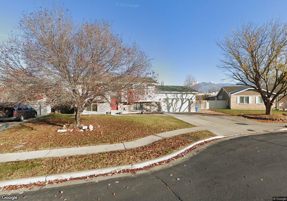
454 W 230 S American Fork, UT 84003
Estimated Value: $475,000 - $550,000
4
Beds
2
Baths
1,675
Sq Ft
$311/Sq Ft
Est. Value
About This Home
This home is located at 454 W 230 S, American Fork, UT 84003 and is currently estimated at $520,880, approximately $310 per square foot. 454 W 230 S is a home located in Utah County with nearby schools including Greenwood Elementary School, American Fork Junior High School, and American Fork High School.
Ownership History
Date
Name
Owned For
Owner Type
Purchase Details
Closed on
Jun 12, 2024
Sold by
Buonforte Jordan
Bought by
Buonforte Jordan and Velazquez Isabel
Current Estimated Value
Purchase Details
Closed on
Mar 12, 2024
Sold by
Opendoor Property Trust
Bought by
Buonforte Jordan
Home Financials for this Owner
Home Financials are based on the most recent Mortgage that was taken out on this home.
Original Mortgage
$500,762
Interest Rate
6.17%
Mortgage Type
FHA
Purchase Details
Closed on
Oct 30, 2023
Sold by
Hooley Billy Joe and Frost James
Bought by
Opendoor Property Trust
Purchase Details
Closed on
Nov 6, 2019
Sold by
Hooley Billy Joe and Price Judy
Bought by
Hooley Billy Joe and Frost James
Home Financials for this Owner
Home Financials are based on the most recent Mortgage that was taken out on this home.
Original Mortgage
$271,570
Interest Rate
4.12%
Mortgage Type
FHA
Purchase Details
Closed on
Jul 11, 2018
Sold by
Murdock Michael C and Murdock Brittany L
Bought by
Hooley Billy Joe and Price Judy
Home Financials for this Owner
Home Financials are based on the most recent Mortgage that was taken out on this home.
Original Mortgage
$261,182
Interest Rate
5.12%
Mortgage Type
FHA
Purchase Details
Closed on
Oct 28, 2010
Sold by
Fannie Mae
Bought by
Murdock Michael C and Murdock Brittany L
Home Financials for this Owner
Home Financials are based on the most recent Mortgage that was taken out on this home.
Original Mortgage
$159,111
Interest Rate
4.33%
Mortgage Type
FHA
Purchase Details
Closed on
Aug 13, 2010
Sold by
Oler Steve C
Bought by
Federal National Mortgage Association
Purchase Details
Closed on
May 1, 2006
Sold by
Mae Alwin M and Mae Sunshine K
Bought by
Oler Steven C
Purchase Details
Closed on
Jul 27, 2001
Sold by
Gibson Antony O and Gibson Amy F
Bought by
Tomlinson Tracy
Create a Home Valuation Report for This Property
The Home Valuation Report is an in-depth analysis detailing your home's value as well as a comparison with similar homes in the area
Home Values in the Area
Average Home Value in this Area
Purchase History
| Date | Buyer | Sale Price | Title Company |
|---|---|---|---|
| Buonforte Jordan | -- | Cottonwood Title | |
| Buonforte Jordan | -- | Cottonwood Title | |
| Buonforte Jordan | -- | Cottonwood Title | |
| Opendoor Property Trust | -- | Cottonwood Title | |
| Hooley Billy Joe | -- | Eagle Title Insurance Agency | |
| Hooley Billy Joe | -- | Eagle Pointe Title Ins Agcy | |
| Murdock Michael C | -- | Empire Land Title Inc | |
| Federal National Mortgage Association | $171,386 | None Available | |
| Oler Steven C | -- | Utah First Title Insurance | |
| Tomlinson Tracy | -- | Equity Title Agency Inc |
Source: Public Records
Mortgage History
| Date | Status | Borrower | Loan Amount |
|---|---|---|---|
| Previous Owner | Buonforte Jordan | $500,762 | |
| Previous Owner | Hooley Billy Joe | $271,570 | |
| Previous Owner | Hooley Billy Joe | $261,182 | |
| Previous Owner | Murdock Michael C | $159,111 |
Source: Public Records
Tax History Compared to Growth
Tax History
| Year | Tax Paid | Tax Assessment Tax Assessment Total Assessment is a certain percentage of the fair market value that is determined by local assessors to be the total taxable value of land and additions on the property. | Land | Improvement |
|---|---|---|---|---|
| 2025 | $2,112 | $256,465 | $199,800 | $266,500 |
| 2024 | $2,112 | $234,685 | $0 | $0 |
| 2023 | $2,015 | $237,325 | $0 | $0 |
| 2022 | $1,970 | $229,020 | $0 | $0 |
| 2021 | $1,634 | $296,700 | $125,400 | $171,300 |
| 2020 | $1,537 | $270,600 | $112,000 | $158,600 |
| 2019 | $1,404 | $255,700 | $101,500 | $154,200 |
| 2018 | $1,313 | $228,600 | $94,500 | $134,100 |
| 2017 | $1,250 | $117,535 | $0 | $0 |
| 2016 | $1,210 | $105,655 | $0 | $0 |
| 2015 | $1,158 | $95,975 | $0 | $0 |
| 2014 | $1,071 | $87,560 | $0 | $0 |
Source: Public Records
Map
Nearby Homes