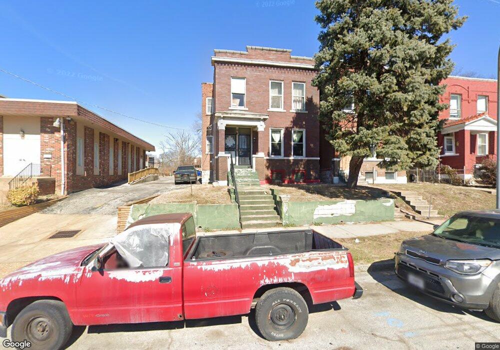
4541 San Francisco Ave Saint Louis, MO 63115
Penrose NeighborhoodEstimated Value: $41,480 - $88,000
--
Bed
2
Baths
2,012
Sq Ft
$35/Sq Ft
Est. Value
About This Home
This home is located at 4541 San Francisco Ave, Saint Louis, MO 63115 and is currently estimated at $69,620, approximately $34 per square foot. 4541 San Francisco Ave is a home located in St. Louis City with nearby schools including Ashland Elementary School, Yeatman-Liddell Middle School, and Sumner High School.
Ownership History
Date
Name
Owned For
Owner Type
Purchase Details
Closed on
Nov 20, 2020
Sold by
Blackwell Larry
Bought by
Lewis Robert L
Current Estimated Value
Purchase Details
Closed on
May 19, 2003
Sold by
Harvey Jerry L
Bought by
Blackwell Larry
Home Financials for this Owner
Home Financials are based on the most recent Mortgage that was taken out on this home.
Original Mortgage
$36,000
Interest Rate
8.62%
Mortgage Type
Purchase Money Mortgage
Create a Home Valuation Report for This Property
The Home Valuation Report is an in-depth analysis detailing your home's value as well as a comparison with similar homes in the area
Home Values in the Area
Average Home Value in this Area
Purchase History
| Date | Buyer | Sale Price | Title Company |
|---|---|---|---|
| Lewis Robert L | $8,500 | None Available | |
| Blackwell Larry | -- | -- |
Source: Public Records
Mortgage History
| Date | Status | Borrower | Loan Amount |
|---|---|---|---|
| Previous Owner | Blackwell Larry | $36,000 | |
| Closed | Blackwell Larry | $4,500 |
Source: Public Records
Tax History Compared to Growth
Tax History
| Year | Tax Paid | Tax Assessment Tax Assessment Total Assessment is a certain percentage of the fair market value that is determined by local assessors to be the total taxable value of land and additions on the property. | Land | Improvement |
|---|---|---|---|---|
| 2025 | $400 | $4,610 | $250 | $4,360 |
| 2024 | $381 | $4,440 | $250 | $4,190 |
| 2023 | $381 | $4,440 | $250 | $4,190 |
| 2022 | $388 | $4,360 | $250 | $4,110 |
| 2021 | $388 | $4,360 | $250 | $4,110 |
| 2020 | $369 | $4,160 | $250 | $3,910 |
| 2019 | $368 | $4,160 | $250 | $3,910 |
| 2018 | $359 | $3,940 | $250 | $3,690 |
| 2017 | $353 | $3,930 | $250 | $3,690 |
| 2016 | $378 | $4,180 | $490 | $3,690 |
| 2015 | $345 | $4,180 | $490 | $3,690 |
| 2014 | $390 | $4,180 | $490 | $3,690 |
| 2013 | -- | $4,770 | $490 | $4,280 |
Source: Public Records
Map
Nearby Homes
- 4538 San Francisco Ave
- 4534 Margaretta Ave
- 3003 TAYOR N Taylor Ave
- 3624 N Taylor Ave
- 4629 Farlin Ave
- 4416 San Francisco Ave
- 4429 Farlin Ave
- 4713-4715 Natural Bridge Ave
- 4607 Lee Ave
- 4707 Farlin Ave
- 4499 Lee Ave Unit B
- 3526 Paris Ave
- 4681 Kossuth Ave
- 4655 Lee Ave
- 3209 N Taylor Ave
- 4718 Lexington Ave
- 4669 Elmbank Ave
- 4628 Elmbank Ave
- 4823 San Francisco Ave
- 4236 W Sacramento Ave
- 4545 San Francisco Ave
- 4535 San Francisco Ave
- 4557 San Francisco Ave
- 4531 San Francisco Ave
- 3916 Cora Ave
- 4527 San Francisco Ave
- 4525 San Francisco Ave
- 3924 Cora Ave
- 4521 San Francisco Ave
- 3926 Cora Ave
- 4542 Margaretta Ave
- 4538 Margaretta Ave
- 4546 Margaretta Ave
- 3734 Cora Ave
- 4530 Margaretta Ave
- 4544 San Francisco Ave
- 4542 San Francisco Ave
- 4517 San Francisco Ave
- 4517 San Francisco Ave Unit 4
- 4601 San Francisco Ave