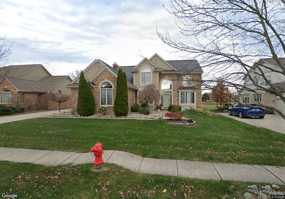
45518 Muirfield Dr Canton, MI 48188
Estimated Value: $554,411 - $660,000
4
Beds
3
Baths
2,952
Sq Ft
$208/Sq Ft
Est. Value
About This Home
This home is located at 45518 Muirfield Dr, Canton, MI 48188 and is currently estimated at $614,103, approximately $208 per square foot. 45518 Muirfield Dr is a home located in Wayne County with nearby schools including Canton High School, Plymouth High School, and Salem High School.
Ownership History
Date
Name
Owned For
Owner Type
Purchase Details
Closed on
Oct 12, 2010
Sold by
Sohn Do Yeon and Sohn Kyung Eun
Bought by
Rabbah Khaled
Current Estimated Value
Purchase Details
Closed on
Jul 24, 1998
Sold by
Carrin Gary T and Carrin Sandra J
Bought by
Sohn Do Y Kyung Eun
Purchase Details
Closed on
Nov 27, 1995
Sold by
Zestos Maria M
Bought by
Zestos Maria M
Purchase Details
Closed on
Mar 5, 1993
Sold by
Fairway Pines Ltd Ptns
Bought by
Curtis Canton Co Ptns
Create a Home Valuation Report for This Property
The Home Valuation Report is an in-depth analysis detailing your home's value as well as a comparison with similar homes in the area
Home Values in the Area
Average Home Value in this Area
Purchase History
| Date | Buyer | Sale Price | Title Company |
|---|---|---|---|
| Rabbah Khaled | $290,000 | None Available | |
| Sohn Do Y Kyung Eun | $332,000 | -- | |
| Zestos Maria M | $306,706 | -- | |
| Curtis Canton Co Ptns | $55,000 | -- |
Source: Public Records
Tax History
| Year | Tax Paid | Tax Assessment Tax Assessment Total Assessment is a certain percentage of the fair market value that is determined by local assessors to be the total taxable value of land and additions on the property. | Land | Improvement |
|---|---|---|---|---|
| 2025 | $3,221 | $238,000 | $0 | $0 |
| 2024 | $3,129 | $224,900 | $0 | $0 |
| 2023 | $2,983 | $195,200 | $0 | $0 |
| 2022 | $6,466 | $190,700 | $0 | $0 |
| 2021 | $3,518 | $188,000 | $0 | $0 |
| 2020 | $6,195 | $185,300 | $0 | $0 |
| 2019 | $6,080 | $172,120 | $0 | $0 |
| 2018 | $2,535 | $164,210 | $0 | $0 |
| 2017 | $6,137 | $161,600 | $0 | $0 |
| 2016 | $5,524 | $162,500 | $0 | $0 |
| 2015 | $13,930 | $151,430 | $0 | $0 |
| 2013 | $13,495 | $148,110 | $0 | $0 |
| 2010 | -- | $130,930 | $68,763 | $62,167 |
Source: Public Records
Map
Nearby Homes
- 241 Country Club Ln
- 45246 Gerald Ct
- 46985 Glastonbury Dr
- 51083 Meadowlands
- 45169 Middlebury Ln
- 45863 Baywood Blvd
- 215 Edington Cir
- 241 Edington Cir
- 46501 Killarney Cir
- 1752 Thistle Dr
- 45678 Aragon Ln
- 1244 W Crystal Cir
- 1289 Old Colony Ln Unit 232
- 1276 W Crystal Cir Unit 202
- 1849 Wentworth Ct
- 345 Canton Center Rd
- 47450 Ellery Ln
- 45679 N Stonewood Rd Unit 58
- 45874 S Stonewood Rd Unit 221
- 48030 Cherry Hill Rd
- 45514 Muirfield Dr
- 45522 Muirfield Dr
- 45526 Muirfield Dr
- 45510 Muirfield Dr
- 45519 Muirfield Dr Unit Bldg-Unit
- 45519 Muirfield Dr
- 45523 Muirfield Dr
- 45515 Muirfield Dr
- 45528 Muirfield Dr
- 45506 Muirfield Dr
- 45540 Muirfield Ct
- 45545 Muirfield Ct
- 45511 Muirfield Dr Unit 28
- 45497 Augusta Dr
- 45502 Muirfield Dr
- 45546 Muirfield Ct
- 45503 Augusta Dr
- 45530 Muirfield Dr
- 45507 Muirfield Dr
- 45491 Augusta Dr
Your Personal Tour Guide
Ask me questions while you tour the home.