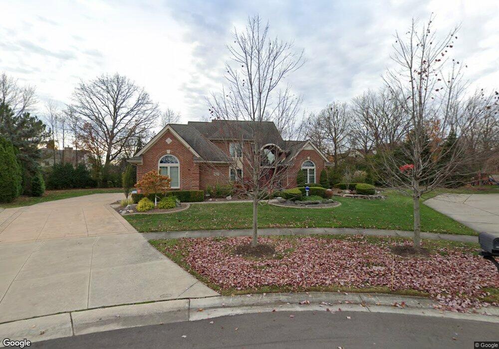
45550 Muirfield Ct Canton, MI 48188
Estimated Value: $567,874 - $637,000
--
Bed
3
Baths
2,666
Sq Ft
$228/Sq Ft
Est. Value
About This Home
This home is located at 45550 Muirfield Ct, Canton, MI 48188 and is currently estimated at $608,719, approximately $228 per square foot. 45550 Muirfield Ct is a home located in Wayne County with nearby schools including Canton High School, Plymouth High School, and Salem High School.
Ownership History
Date
Name
Owned For
Owner Type
Purchase Details
Closed on
Dec 6, 2016
Sold by
Perry Patricia A
Bought by
Patricia A Parry Revocable Trust
Current Estimated Value
Purchase Details
Closed on
Nov 29, 2004
Sold by
Perry Ronald H and Perry Patricia A
Bought by
Perry Ronald H
Purchase Details
Closed on
Mar 5, 1993
Sold by
Fairway Pines Ltd Ptns
Bought by
Selective Fairway Corp
Create a Home Valuation Report for This Property
The Home Valuation Report is an in-depth analysis detailing your home's value as well as a comparison with similar homes in the area
Home Values in the Area
Average Home Value in this Area
Purchase History
| Date | Buyer | Sale Price | Title Company |
|---|---|---|---|
| Patricia A Parry Revocable Trust | -- | None Available | |
| Perry Patricia A | -- | None Available | |
| Perry Ronald H | -- | -- | |
| Selective Fairway Corp | $55,000 | -- |
Source: Public Records
Tax History Compared to Growth
Tax History
| Year | Tax Paid | Tax Assessment Tax Assessment Total Assessment is a certain percentage of the fair market value that is determined by local assessors to be the total taxable value of land and additions on the property. | Land | Improvement |
|---|---|---|---|---|
| 2025 | $3,932 | $276,000 | $0 | $0 |
| 2024 | $3,932 | $255,500 | $0 | $0 |
| 2023 | $3,749 | $218,600 | $0 | $0 |
| 2022 | $8,083 | $214,200 | $0 | $0 |
| 2021 | $7,841 | $211,800 | $0 | $0 |
| 2020 | $7,746 | $208,800 | $0 | $0 |
| 2019 | $7,601 | $193,160 | $0 | $0 |
| 2018 | $3,186 | $180,900 | $0 | $0 |
| 2017 | $7,815 | $179,800 | $0 | $0 |
| 2016 | $6,162 | $180,800 | $0 | $0 |
| 2015 | $15,587 | $168,740 | $0 | $0 |
| 2013 | $15,100 | $165,140 | $0 | $0 |
| 2010 | -- | $146,520 | $83,753 | $62,767 |
Source: Public Records
Map
Nearby Homes
- 241 Country Club Ln
- 51026 Meadowlands
- 316 Queen Anne Dr
- 45400 William Ct
- 47078 Bing Dr
- 500 Belvedere Ct N
- 1564 Crowndale Ln
- 45242 Thornhill Rd
- 1861 Stonebridge Way
- 45801 Henley Dr
- 288 Edington Cir Unit 61
- 1752 Thistle Dr
- 1709 Thistle Dr Unit 51
- 45030 Glengarry Rd
- 46502 Killarney Cir Unit 191
- 227 Edington Cir
- 685 N Beck Rd
- 2498 Cleveland Way
- 2304 Cleveland Way
- 45814 Aragon Ln
- 45554 Muirfield Ct
- 46451 Inverness Rd
- 46425 Inverness Rd
- 45551 Muirfield Ct
- 46475 Inverness Rd
- 45555 Glengarry Blvd
- 46403 Inverness Rd
- 45546 Muirfield Ct
- 45553 Muirfield Ct
- 46523 Inverness Rd
- 45545 Muirfield Ct
- 45547 Glengarry Blvd
- 45540 Muirfield Ct
- 46430 Inverness Rd
- 45523 Muirfield Dr
- 46462 Inverness Rd
- 46547 Inverness Rd
- 46491 Glengarry Blvd Unit Bldg-Unit
- 46491 Glengarry Blvd
- 45543 Glengarry Blvd