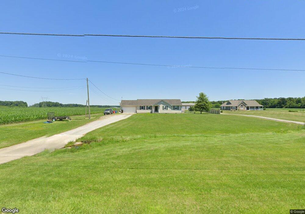
4557 Bardwell Buford Rd Mount Orab, OH 45154
Estimated Value: $238,000 - $275,000
3
Beds
2
Baths
1,512
Sq Ft
$172/Sq Ft
Est. Value
About This Home
This home is located at 4557 Bardwell Buford Rd, Mount Orab, OH 45154 and is currently estimated at $260,440, approximately $172 per square foot. 4557 Bardwell Buford Rd is a home located in Brown County with nearby schools including Western Brown High School.
Ownership History
Date
Name
Owned For
Owner Type
Purchase Details
Closed on
Feb 21, 2007
Sold by
Clifton Barry Lee and Clifton Tonia
Bought by
Chirco Joseph A and Chirco Tabitha R
Current Estimated Value
Home Financials for this Owner
Home Financials are based on the most recent Mortgage that was taken out on this home.
Original Mortgage
$126,000
Interest Rate
6.79%
Mortgage Type
Unknown
Purchase Details
Closed on
May 14, 2001
Sold by
Gatch J Earl
Bought by
Clifton Barry L
Create a Home Valuation Report for This Property
The Home Valuation Report is an in-depth analysis detailing your home's value as well as a comparison with similar homes in the area
Purchase History
| Date | Buyer | Sale Price | Title Company |
|---|---|---|---|
| Chirco Joseph A | $126,000 | None Available | |
| Clifton Barry L | $13,553 | -- |
Source: Public Records
Mortgage History
| Date | Status | Borrower | Loan Amount |
|---|---|---|---|
| Previous Owner | Chirco Joseph A | $126,000 |
Source: Public Records
Tax History
| Year | Tax Paid | Tax Assessment Tax Assessment Total Assessment is a certain percentage of the fair market value that is determined by local assessors to be the total taxable value of land and additions on the property. | Land | Improvement |
|---|---|---|---|---|
| 2024 | $1,682 | $60,140 | $9,980 | $50,160 |
| 2023 | $1,682 | $46,180 | $6,910 | $39,270 |
| 2022 | $1,382 | $46,180 | $6,910 | $39,270 |
| 2021 | $1,362 | $46,180 | $6,910 | $39,270 |
| 2020 | $1,223 | $40,160 | $6,010 | $34,150 |
| 2019 | $1,312 | $40,160 | $6,010 | $34,150 |
| 2018 | $1,301 | $40,160 | $6,010 | $34,150 |
| 2017 | $1,197 | $36,770 | $5,450 | $31,320 |
| 2016 | $1,197 | $36,770 | $5,450 | $31,320 |
| 2015 | $1,191 | $36,770 | $5,450 | $31,320 |
| 2014 | $1,212 | $36,280 | $4,960 | $31,320 |
| 2013 | $1,208 | $36,280 | $4,960 | $31,320 |
Source: Public Records
Map
Nearby Homes
- 3517 Bardwell Buford Rd
- 206 Bingaman Ln
- 203 Bingaman Ln
- 102 Lonny St
- 108 Lonny St
- 506 E Main St
- 329 E Main St
- 216 Gregory St
- 224 Gregory St
- 226 Gregory St
- 414 Castle Ave
- 0 State Route 32 Unit 1795308
- 311 Smith Ave
- 5176 E Greenbush Rd
- 102 Tom's Turnaround
- 1927 Maple Grove B
- 0 7-Acres Dean Dr Unit 1870915
- 419 Liming Farm Rd
- 0 Bardwell W Unit 1854344
- 781 S High St
- 4556 Bardwell Buford Rd
- 4602 Bardwell Buford Rd
- 4609 Bardwell Buford Rd
- 4498 Bardwell Buford Rd
- 4612 Bardwell Buford Rd
- 4514 Bardwell Buford Rd
- acres Bardwell Buford Rd
- 4634 Bardwell Buford Rd
- 4462 Bardwell Buford Rd
- 4641 Bardwell Buford Rd
- 4654 Bardwell Buford Rd
- 4674 Bardwell Buford Rd
- 4432 Bardwell Buford Rd
- 3809 Bardwell Buford Rd
- 4700 Bardwell Buford Rd
- 4413 Bardwell Buford Rd
- 4746 Bardwell Buford Rd
- 4747 Bardwell Buford Rd
- 4367 Bardwell Buford Rd
- 4353 Bardwell Buford Rd
Your Personal Tour Guide
Ask me questions while you tour the home.