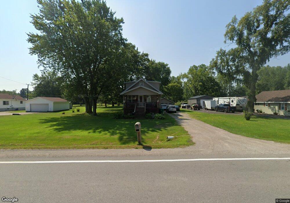
4559 Griswold Rd Kimball, MI 48074
Estimated Value: $158,000 - $181,000
3
Beds
1
Bath
1,563
Sq Ft
$110/Sq Ft
Est. Value
About This Home
This home is located at 4559 Griswold Rd, Kimball, MI 48074 and is currently estimated at $171,743, approximately $109 per square foot. 4559 Griswold Rd is a home located in St. Clair County with nearby schools including Kimball Elementary School, Central Middle School, and Port Huron High School.
Ownership History
Date
Name
Owned For
Owner Type
Purchase Details
Closed on
Apr 3, 2019
Sold by
Sheriff Of St Clair County
Bought by
Asset Link Llc
Current Estimated Value
Purchase Details
Closed on
Mar 29, 2019
Sold by
Hawley Mark J
Bought by
Asset Link Llc
Purchase Details
Closed on
Aug 11, 2006
Sold by
Bartley Eric R and Bartley Lori L
Bought by
Hawley Mark J
Home Financials for this Owner
Home Financials are based on the most recent Mortgage that was taken out on this home.
Original Mortgage
$105,466
Interest Rate
6.83%
Mortgage Type
FHA
Create a Home Valuation Report for This Property
The Home Valuation Report is an in-depth analysis detailing your home's value as well as a comparison with similar homes in the area
Home Values in the Area
Average Home Value in this Area
Purchase History
| Date | Buyer | Sale Price | Title Company |
|---|---|---|---|
| Asset Link Llc | $37,501 | None Listed On Document | |
| Asset Link Llc | $1,000 | None Listed On Document | |
| Hawley Mark J | $106,300 | Metropolitan Title Company |
Source: Public Records
Mortgage History
| Date | Status | Borrower | Loan Amount |
|---|---|---|---|
| Previous Owner | Hawley Mark J | $105,466 |
Source: Public Records
Tax History Compared to Growth
Tax History
| Year | Tax Paid | Tax Assessment Tax Assessment Total Assessment is a certain percentage of the fair market value that is determined by local assessors to be the total taxable value of land and additions on the property. | Land | Improvement |
|---|---|---|---|---|
| 2025 | $2,494 | $64,000 | $0 | $0 |
| 2024 | $1,785 | $63,500 | $0 | $0 |
| 2023 | $1,670 | $61,200 | $0 | $0 |
| 2022 | $2,224 | $53,600 | $0 | $0 |
| 2021 | $2,064 | $51,200 | $0 | $0 |
| 2020 | $2,064 | $45,800 | $0 | $45,800 |
| 2019 | $969 | $41,500 | $0 | $0 |
| 2018 | $1,134 | $39,600 | $0 | $0 |
| 2017 | $1,084 | $40,800 | $0 | $0 |
| 2016 | $465 | $40,800 | $0 | $0 |
| 2015 | -- | $39,100 | $9,400 | $29,700 |
| 2014 | -- | $32,700 | $9,400 | $23,300 |
| 2013 | -- | $40,500 | $0 | $0 |
Source: Public Records
Map
Nearby Homes
- 4595 Griswold Rd
- 0000 Range Rd
- 4632 Cloverdale Ln
- 0 Wall Rd Unit 50185999
- 1405 Range Rd
- 00 Howard Rd
- 00 Range Rd
- 1979 Allen Rd
- V/L Allen
- 1701 Allen Rd
- 0 Allen Rd Unit 20250008597
- 0 Allen Rd Unit 20250008612
- 1604 Allen Rd
- 4380 Lapeer Rd
- V/L Partridge Rd
- 0 Lapeer Rd Unit 50137357
- 2650 Alger Rd
- 4911 Castlewood Dr
- 174 Meadow Ln
- 104 Oldbrook Ln
- 4567 Griswold Rd
- 4545 Griswold Rd
- V/L Vac Griswold Rd
- 4575 Griswold Rd
- 4539 Griswold Rd
- 4566 Griswold Rd
- 4542 Griswold Rd
- 4552 Griswold Rd
- 4560 Griswold Rd
- 4533 Griswold Rd
- 4585 Griswold Rd
- 4576 Griswold Rd
- 4526 Griswold Rd
- 4587 Griswold Rd
- 4590 Griswold Rd
- 4523 Griswold Rd
- 4602 Griswold Rd
- 4605 Griswold Rd
- 4606 Griswold Rd
- 1991 Range Rd