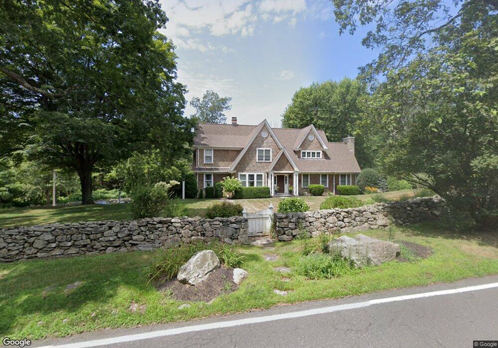
456 Westport Rd Easton, CT 06612
Estimated Value: $1,038,000 - $1,181,000
4
Beds
3
Baths
2,868
Sq Ft
$384/Sq Ft
Est. Value
About This Home
This home is located at 456 Westport Rd, Easton, CT 06612 and is currently estimated at $1,101,666, approximately $384 per square foot. 456 Westport Rd is a home located in Fairfield County with nearby schools including Samuel Staples Elementary School, Helen Keller Middle School, and Joel Barlow High School.
Ownership History
Date
Name
Owned For
Owner Type
Purchase Details
Closed on
Jul 31, 2012
Sold by
Marcocci Christopher W and Marcocci Rita A
Bought by
Lippoth John K and Lippoth Hilary N
Current Estimated Value
Create a Home Valuation Report for This Property
The Home Valuation Report is an in-depth analysis detailing your home's value as well as a comparison with similar homes in the area
Home Values in the Area
Average Home Value in this Area
Purchase History
| Date | Buyer | Sale Price | Title Company |
|---|---|---|---|
| Lippoth John K | $775,000 | -- | |
| Lippoth John K | $775,000 | -- |
Source: Public Records
Mortgage History
| Date | Status | Borrower | Loan Amount |
|---|---|---|---|
| Previous Owner | Lippoth John K | $641,750 | |
| Previous Owner | Lippoth John K | $50,000 | |
| Closed | Lippoth John K | $0 |
Source: Public Records
Tax History Compared to Growth
Tax History
| Year | Tax Paid | Tax Assessment Tax Assessment Total Assessment is a certain percentage of the fair market value that is determined by local assessors to be the total taxable value of land and additions on the property. | Land | Improvement |
|---|---|---|---|---|
| 2025 | $16,659 | $537,390 | $219,240 | $318,150 |
| 2024 | $15,875 | $537,390 | $219,240 | $318,150 |
| 2023 | $15,563 | $537,390 | $219,240 | $318,150 |
| 2022 | $15,283 | $537,390 | $219,240 | $318,150 |
| 2021 | $13,514 | $417,740 | $180,180 | $237,560 |
| 2020 | $12,950 | $417,740 | $180,180 | $237,560 |
| 2019 | $13,088 | $417,740 | $180,180 | $237,560 |
| 2018 | $13,109 | $417,740 | $180,180 | $237,560 |
| 2017 | $13,944 | $417,740 | $180,180 | $237,560 |
| 2016 | $12,962 | $420,700 | $207,900 | $212,800 |
| 2015 | $12,781 | $420,700 | $207,900 | $212,800 |
| 2014 | $12,579 | $420,700 | $207,900 | $212,800 |
Source: Public Records
Map
Nearby Homes
- 80 Norton Rd
- 354 Black Rock Turnpike
- 100 Honeysuckle Hill Ln
- 18 Wells Hill Rd
- 90 Redding Rd
- 8 Messex Ln
- 85 Westport Rd
- 3 Mayflower Ln
- 64 Old Redding Rd
- 100 E Common Rd
- 29 Old Stage Coach Rd
- 48 Sunset Rd
- 39 Sunset Rd
- 76 Burr St
- 305 Sport Hill Rd
- 16 Manor Ln
- 101 Northwood Dr
- 63 Flat Rock Dr
- 111 & 115 Old Easton Turnpike
- 897 Sport Hill Rd
- 456 Westport Rd
- 460 Westport Rd
- 455 Westport Rd
- 463 Westport Rd
- 463 Westport Rd
- 445 Westport Rd
- 475 Westport Rd
- 438 Westport Rd
- 345 Wilson Rd
- 449 Westport Rd
- 425 Westport Rd
- 425 Westport Rd
- 333 Wilson Rd
- 420 Westport Rd
- 323 Wilson Rd
- 350 Wilson Rd
- 9 Old Sow Rd
- 413 Westport Rd
- 340 Wilson Rd
- 334 Wilson Rd