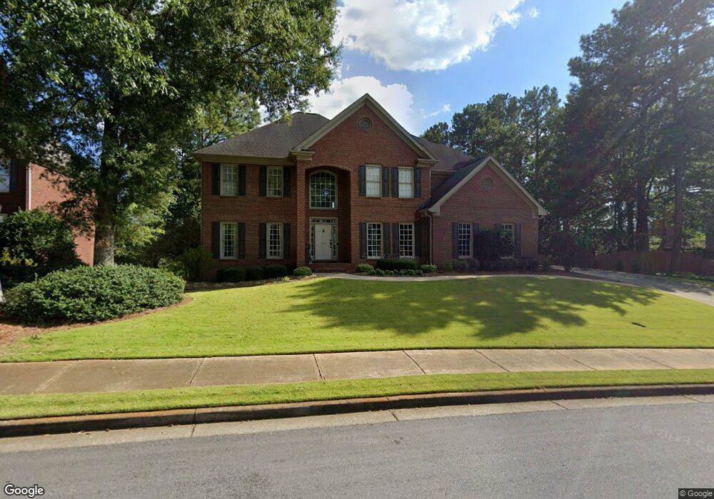
4565 Park Brooke Trace Unit 2 Alpharetta, GA 30022
Estimated Value: $999,000 - $1,100,000
5
Beds
4
Baths
3,566
Sq Ft
$292/Sq Ft
Est. Value
About This Home
This home is located at 4565 Park Brooke Trace Unit 2, Alpharetta, GA 30022 and is currently estimated at $1,042,412, approximately $292 per square foot. 4565 Park Brooke Trace Unit 2 is a home located in Fulton County with nearby schools including Ocee Elementary School, Webb Bridge Middle School, and Alpharetta High School.
Ownership History
Date
Name
Owned For
Owner Type
Purchase Details
Closed on
Apr 21, 1994
Sold by
Miller Eldon Homes Inc
Bought by
Noel Thomas W Nancy J
Current Estimated Value
Home Financials for this Owner
Home Financials are based on the most recent Mortgage that was taken out on this home.
Original Mortgage
$218,500
Interest Rate
8.24%
Create a Home Valuation Report for This Property
The Home Valuation Report is an in-depth analysis detailing your home's value as well as a comparison with similar homes in the area
Home Values in the Area
Average Home Value in this Area
Purchase History
| Date | Buyer | Sale Price | Title Company |
|---|---|---|---|
| Noel Thomas W Nancy J | $286,600 | -- |
Source: Public Records
Mortgage History
| Date | Status | Borrower | Loan Amount |
|---|---|---|---|
| Closed | Noel Thomas W Nancy J | $218,500 |
Source: Public Records
Tax History Compared to Growth
Tax History
| Year | Tax Paid | Tax Assessment Tax Assessment Total Assessment is a certain percentage of the fair market value that is determined by local assessors to be the total taxable value of land and additions on the property. | Land | Improvement |
|---|---|---|---|---|
| 2025 | $895 | $361,440 | $111,440 | $250,000 |
| 2023 | $7,820 | $277,040 | $69,440 | $207,600 |
| 2022 | $3,972 | $226,560 | $55,600 | $170,960 |
| 2021 | $4,682 | $207,920 | $53,120 | $154,800 |
| 2020 | $4,710 | $205,480 | $52,520 | $152,960 |
| 2019 | $842 | $201,800 | $51,560 | $150,240 |
| 2018 | $4,965 | $197,080 | $50,360 | $146,720 |
| 2017 | $4,570 | $168,680 | $42,520 | $126,160 |
| 2016 | $4,548 | $168,680 | $42,520 | $126,160 |
| 2015 | $5,334 | $168,680 | $42,520 | $126,160 |
| 2014 | $4,720 | $168,680 | $42,520 | $126,160 |
Source: Public Records
Map
Nearby Homes
- 437 Argosy Park Cir
- 4465 Park Brooke Trace Unit 5
- 3965 Brookline Dr
- Dunwoody Plan at Brookmeade Trail
- Peterson with Basement Plan at Hawthorn
- Peterson Plan at Hawthorn
- Roswell Plan at Brookmeade Trail
- Payton Plan at Brookmeade Trail
- Rosalynn with Basement Plan at Hawthorn
- Donington with Basement Plan at Hawthorn
- Rosalynn Plan at Hawthorn
- Parkmont with Basement Plan at Hawthorn
- Donington Plan at Hawthorn
- Rousseau Plan at Hawthorn
- Rosewater Transitional Plan at Brookmeade Trail
- Rhinewood Plan at Hawthorn
- Portis Plan at Hawthorn
- Rosewater Plan at Brookmeade Trail
- Parkstone Plan at Brookmeade Trail
- Parkmont Plan at Hawthorn
- 4575 Park Brooke Trace
- 4555 Park Brooke Trace Unit 2
- 925 Brookline Way Unit 3
- 4245 Park Brooke Dr Unit 2
- 4550 Park Brooke Trace Unit 2
- 4585 Park Brooke Trace
- 600 Brookline Ridge Unit 2
- 915 Brookline Way
- 4720 Park Brooke Dr
- 4540 Park Brooke Trace
- 4235 Park Brooke Dr Unit 2
- 945 Brookline Way
- 4535 Park Brooke Trace Unit 2
- 715 Brookline Trace
- 705 Brookline Trace
- 4530 Park Brooke Trace
- 4280 Park Brooke Dr
- 4580 Park Brooke Trace
- 4225 Park Brooke Dr Unit 2
- 910 Brookline Way Unit 33