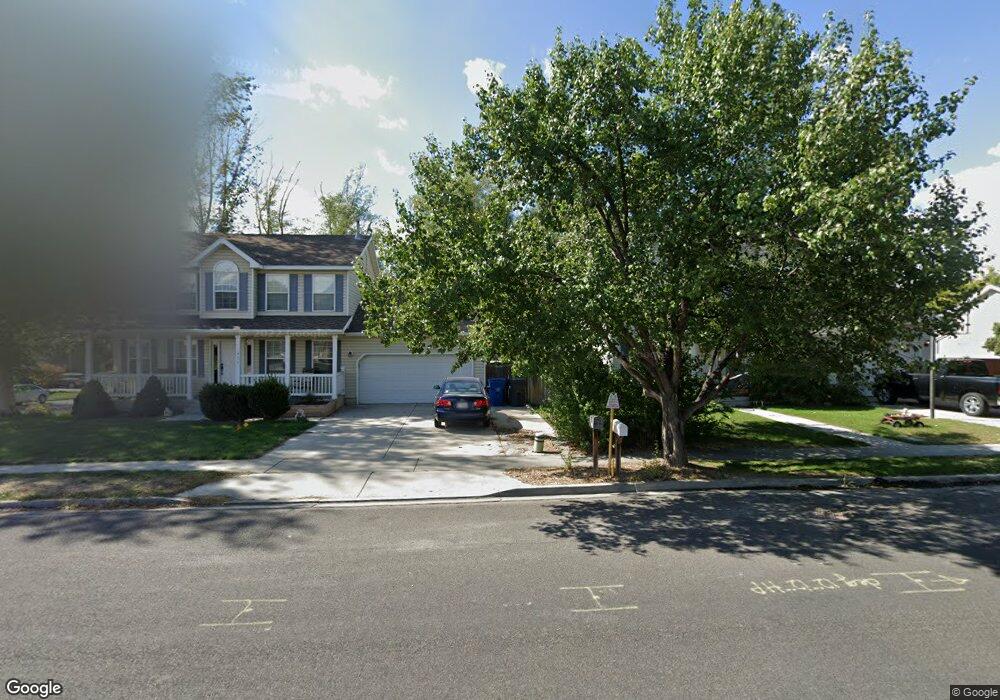
457 N 570 W American Fork, UT 84003
Estimated Value: $360,000 - $384,000
3
Beds
2
Baths
1,300
Sq Ft
$287/Sq Ft
Est. Value
About This Home
This home is located at 457 N 570 W, American Fork, UT 84003 and is currently estimated at $373,065, approximately $286 per square foot. 457 N 570 W is a home located in Utah County with nearby schools including Shelley Elementary School, American Fork Junior High School, and American Fork High School.
Ownership History
Date
Name
Owned For
Owner Type
Purchase Details
Closed on
May 15, 2018
Sold by
Sizer Sonya E and Allen Sonya E
Bought by
Sizer Michael A and Sizer Sonya E
Current Estimated Value
Purchase Details
Closed on
Jun 27, 2005
Sold by
Harris Jeanne
Bought by
Allen Sonya E
Home Financials for this Owner
Home Financials are based on the most recent Mortgage that was taken out on this home.
Original Mortgage
$96,000
Outstanding Balance
$50,081
Interest Rate
5.65%
Mortgage Type
Fannie Mae Freddie Mac
Estimated Equity
$322,984
Purchase Details
Closed on
Nov 22, 2002
Sold by
Harris Jeanne
Bought by
Harris Jeanne
Home Financials for this Owner
Home Financials are based on the most recent Mortgage that was taken out on this home.
Original Mortgage
$86,000
Interest Rate
6.12%
Create a Home Valuation Report for This Property
The Home Valuation Report is an in-depth analysis detailing your home's value as well as a comparison with similar homes in the area
Home Values in the Area
Average Home Value in this Area
Purchase History
| Date | Buyer | Sale Price | Title Company |
|---|---|---|---|
| Sizer Michael A | -- | None Available | |
| Allen Sonya E | -- | Utah Standard Title | |
| Harris Jeanne | -- | Signature Title |
Source: Public Records
Mortgage History
| Date | Status | Borrower | Loan Amount |
|---|---|---|---|
| Open | Allen Sonya E | $96,000 | |
| Previous Owner | Harris Jeanne | $86,000 |
Source: Public Records
Tax History
| Year | Tax Paid | Tax Assessment Tax Assessment Total Assessment is a certain percentage of the fair market value that is determined by local assessors to be the total taxable value of land and additions on the property. | Land | Improvement |
|---|---|---|---|---|
| 2025 | $1,704 | $181,775 | -- | -- |
| 2024 | $1,704 | $189,310 | $0 | $0 |
| 2023 | $1,468 | $172,975 | $0 | $0 |
| 2022 | $1,640 | $190,630 | $0 | $0 |
| 2021 | $1,344 | $244,000 | $36,600 | $207,400 |
| 2020 | $1,271 | $223,800 | $33,600 | $190,200 |
| 2019 | $1,038 | $189,100 | $28,400 | $160,700 |
| 2018 | $930 | $162,000 | $24,300 | $137,700 |
| 2017 | $849 | $79,805 | $0 | $0 |
| 2016 | $863 | $75,350 | $0 | $0 |
| 2015 | $909 | $75,350 | $0 | $0 |
| 2014 | $807 | $66,000 | $0 | $0 |
Source: Public Records
Map
Nearby Homes
- 589 W 480 N
- 777 W State Rd
- 164 N 450 W
- 831 N 600 W
- 599 W 860 N
- 822 W 800 St N Unit LOT319
- 484 N 950 W Unit 7
- 822 N 860 W Unit 317
- 120 N 350 W Unit 127
- 120 N 350 W Unit 133
- 120 N 350 W Unit 130
- 120 N 350 W Unit 129
- 120 N 350 W Unit 131
- 764 W 880 North St Unit 308
- 217 W Main St
- 621 N 100 W
- 525 W 990 N
- 4007 W 1000 N
- 3947 W 1000 N Unit 439
- 3971 W 1000 N Unit 441
Your Personal Tour Guide
Ask me questions while you tour the home.