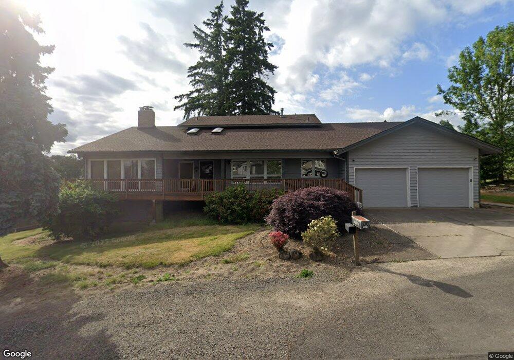
4573 SE Derry Ln Milwaukie, OR 97267
Estimated Value: $820,000 - $1,061,534
3
Beds
3
Baths
4,137
Sq Ft
$233/Sq Ft
Est. Value
About This Home
This home is located at 4573 SE Derry Ln, Milwaukie, OR 97267 and is currently estimated at $961,884, approximately $232 per square foot. 4573 SE Derry Ln is a home located in Clackamas County with nearby schools including Riverside Elementary School, Alder Creek Middle School, and Rex Putnam High School.
Ownership History
Date
Name
Owned For
Owner Type
Purchase Details
Closed on
Aug 22, 2024
Sold by
Foelker Colleen Adele
Bought by
Lacolucci Martin Joseph and Lacolucci Bernard Craig
Current Estimated Value
Purchase Details
Closed on
Jul 8, 2021
Sold by
Foelker William Scott
Bought by
Iacolucci Bernard Craig
Purchase Details
Closed on
Jan 19, 2017
Sold by
Lacolucci Ben
Bought by
Lacolucci Ben and The Ben Lacolucci Living Trust
Create a Home Valuation Report for This Property
The Home Valuation Report is an in-depth analysis detailing your home's value as well as a comparison with similar homes in the area
Home Values in the Area
Average Home Value in this Area
Purchase History
| Date | Buyer | Sale Price | Title Company |
|---|---|---|---|
| Lacolucci Martin Joseph | $240,000 | None Listed On Document | |
| Iacolucci Bernard Craig | -- | None Available | |
| Lacolucci Ben | -- | None Available |
Source: Public Records
Tax History Compared to Growth
Tax History
| Year | Tax Paid | Tax Assessment Tax Assessment Total Assessment is a certain percentage of the fair market value that is determined by local assessors to be the total taxable value of land and additions on the property. | Land | Improvement |
|---|---|---|---|---|
| 2025 | $11,572 | $613,801 | -- | -- |
| 2024 | $11,159 | $595,924 | -- | -- |
| 2023 | $11,159 | $578,567 | $0 | $0 |
| 2022 | $10,255 | $561,716 | $0 | $0 |
| 2021 | $9,877 | $545,356 | $0 | $0 |
| 2020 | $9,559 | $529,472 | $0 | $0 |
| 2019 | $9,421 | $514,051 | $0 | $0 |
| 2018 | $8,233 | $499,079 | $0 | $0 |
| 2017 | $7,964 | $484,543 | $0 | $0 |
| 2016 | $7,676 | $470,430 | $0 | $0 |
| 2015 | $7,454 | $456,728 | $0 | $0 |
| 2014 | $7,046 | $443,425 | $0 | $0 |
Source: Public Records
Map
Nearby Homes
- 4778 SE Naef Rd
- 16855 SE Oatfield Rd
- 4461 SE Naef Rd
- 16305 SE Oatfield Rd
- 15915 SE Harold Ave
- 16642 SE Harold Ave
- 16390 SE Hillside Ln
- 4819 SE Roethe Rd
- 4711 SE Roethe Rd
- 3419 SE Kingsley Rd
- 16620 SE Hampshire Ln
- 5492 SE Hillwood Cir
- 3405 SE Vineyard Rd Unit SP 49
- 3500 SE Concord Rd Unit 78
- 4809 SE Ina Ave
- 4807 SE Ina Ave
- 4803 SE Ina Ave
- 4801 SE Ina Ave
- 4816 SE Robin Rd
- 15109 SE Oatfield Rd
- 4545 SE Derry Ln
- 16246 SE Rayna Ct
- 4644 SE Derry Ln
- 4668 SE Derry Ln
- 4692 SE Derry Ln
- 16238 SE Rayna Ct
- 4620 SE Derry Ln
- 4720 SE Derry Ln
- 16224 SE Rayna Ct
- 4525 SE Derry Ln
- 16121 SE Oatfield Rd
- 4526 SE Derry Ln
- 16003 SE Oatfield Rd
- 16013 SE Oatfield Rd
- 16235 SE Rayna Ct
- 16017 SE Oatfield Rd
- 16202 SE Rayna Ct
- 4619 SE Naef (Fixer)
- 16131 SE Oatfield Rd
- 4607 SE Naef Rd