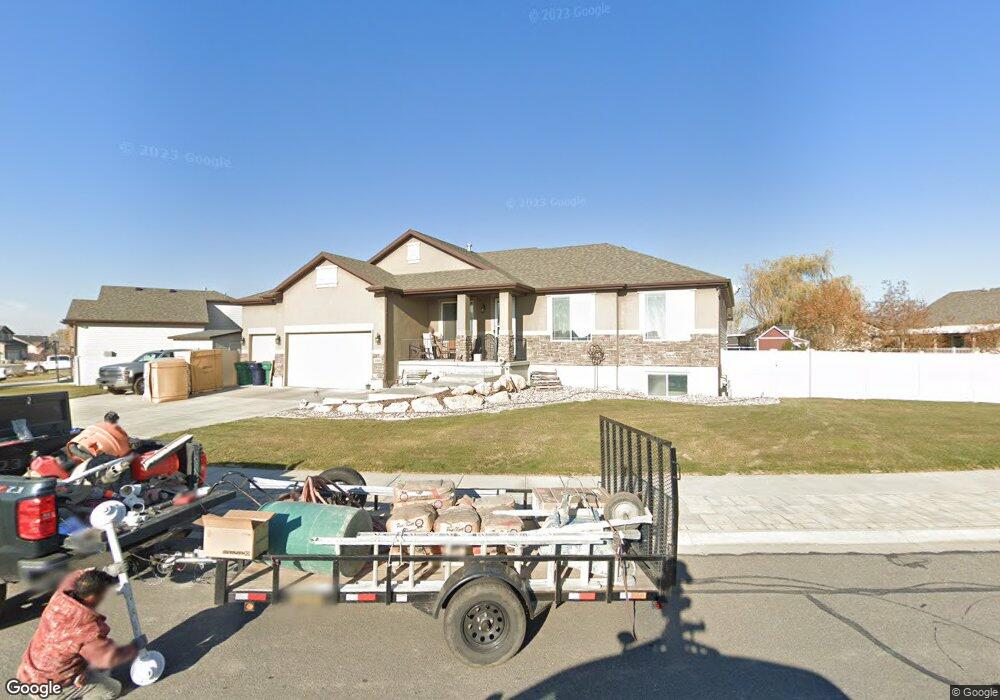
4580 W 5900 S Hooper, UT 84315
Estimated Value: $616,608 - $627,000
4
Beds
4
Baths
1,794
Sq Ft
$347/Sq Ft
Est. Value
About This Home
This home is located at 4580 W 5900 S, Hooper, UT 84315 and is currently estimated at $622,652, approximately $347 per square foot. 4580 W 5900 S is a home with nearby schools including Freedom School, Roy Junior High School, and Roy High School.
Ownership History
Date
Name
Owned For
Owner Type
Purchase Details
Closed on
Jun 14, 2012
Sold by
Lafrance Kenan J
Bought by
Lafrance Kenan J and Lafrance Stacey M
Current Estimated Value
Home Financials for this Owner
Home Financials are based on the most recent Mortgage that was taken out on this home.
Original Mortgage
$238,096
Outstanding Balance
$164,699
Interest Rate
3.79%
Mortgage Type
New Conventional
Estimated Equity
$457,953
Purchase Details
Closed on
Oct 19, 2009
Sold by
Woodside Wildwood Llc
Bought by
Lafrance Kenan J
Home Financials for this Owner
Home Financials are based on the most recent Mortgage that was taken out on this home.
Original Mortgage
$240,500
Interest Rate
5%
Mortgage Type
New Conventional
Create a Home Valuation Report for This Property
The Home Valuation Report is an in-depth analysis detailing your home's value as well as a comparison with similar homes in the area
Home Values in the Area
Average Home Value in this Area
Purchase History
| Date | Buyer | Sale Price | Title Company |
|---|---|---|---|
| Lafrance Kenan J | -- | Lincoln Title Insurance Agen | |
| Lafrance Kenan J | -- | Us Title Insurance Agency |
Source: Public Records
Mortgage History
| Date | Status | Borrower | Loan Amount |
|---|---|---|---|
| Open | Lafrance Kenan J | $238,096 | |
| Closed | Lafrance Kenan J | $240,500 |
Source: Public Records
Tax History
| Year | Tax Paid | Tax Assessment Tax Assessment Total Assessment is a certain percentage of the fair market value that is determined by local assessors to be the total taxable value of land and additions on the property. | Land | Improvement |
|---|---|---|---|---|
| 2025 | $3,654 | $584,534 | $206,509 | $378,025 |
| 2024 | $3,698 | $332,199 | $113,579 | $218,620 |
| 2023 | $3,606 | $321,200 | $112,620 | $208,580 |
| 2022 | $3,691 | $338,800 | $87,711 | $251,089 |
| 2021 | $3,134 | $482,000 | $113,847 | $368,153 |
| 2020 | $2,960 | $418,000 | $108,782 | $309,218 |
| 2019 | $2,866 | $382,000 | $105,760 | $276,240 |
| 2018 | $2,796 | $356,000 | $70,421 | $285,579 |
| 2017 | $2,669 | $328,000 | $69,114 | $258,886 |
| 2016 | $2,241 | $146,625 | $37,439 | $109,186 |
| 2015 | $2,155 | $138,649 | $34,662 | $103,987 |
| 2014 | $1,945 | $120,624 | $29,407 | $91,217 |
Source: Public Records
Map
Nearby Homes
- 2542 N 3300 W
- 4403 W 5700 S
- 4276 W 6025 S
- 3016 W 2650 N
- 3186 W 2600 N
- 4264 W 6025 S
- 3033 W 2600 N
- 6052 S 4275 W
- 3027 W 2600 N
- 4700 W 5500 S
- 2444 N Hooded Crane Cir Unit 11
- 339 N 3250 W Unit 12
- 4337 W 5430 St S A S Unit A
- 2000 Garden Plan at Cranefield Estates - Collection
- 2400 Garden Plan at Cranefield Estates - Collection
- 2500 Farmhouse Plan at Cranefield Estates - Collection
- 1700 Farmhouse Plan at Cranefield Estates - Collection
- San Marino Traditional Plan at Cranefield Estates
- 4309 W 5430 St #B S
- 3826 W 2350 N
Your Personal Tour Guide
Ask me questions while you tour the home.