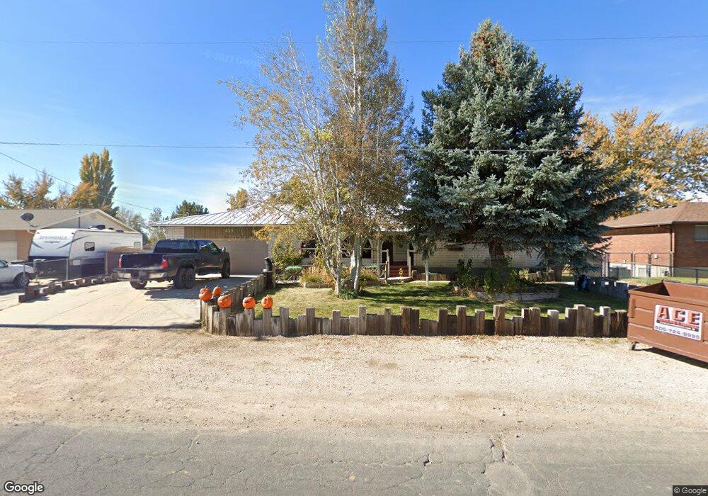
459 N 3500 W Clearfield, UT 84015
Estimated Value: $663,000 - $742,874
5
Beds
3
Baths
3,126
Sq Ft
$221/Sq Ft
Est. Value
About This Home
This home is located at 459 N 3500 W, Clearfield, UT 84015 and is currently estimated at $691,219, approximately $221 per square foot. 459 N 3500 W is a home located in Davis County with nearby schools including West Point School, West Point Junior High School, and Syracuse High School.
Ownership History
Date
Name
Owned For
Owner Type
Purchase Details
Closed on
Sep 26, 2020
Sold by
Hodgins Arthur W
Bought by
Syringa Financial Corporation
Current Estimated Value
Purchase Details
Closed on
Jul 10, 2018
Sold by
Hodings Arthur W
Bought by
Downs Lovica A
Purchase Details
Closed on
Aug 15, 2008
Sold by
Morfin Rox Ann
Bought by
Hodgins Arthur W
Home Financials for this Owner
Home Financials are based on the most recent Mortgage that was taken out on this home.
Original Mortgage
$283,977
Interest Rate
6.32%
Mortgage Type
VA
Create a Home Valuation Report for This Property
The Home Valuation Report is an in-depth analysis detailing your home's value as well as a comparison with similar homes in the area
Home Values in the Area
Average Home Value in this Area
Purchase History
| Date | Buyer | Sale Price | Title Company |
|---|---|---|---|
| Syringa Financial Corporation | -- | Us Title Company Of U | |
| Downs Lovica A | -- | None Available | |
| Hodgins Arthur W | -- | Mountain View Title & Escrow |
Source: Public Records
Mortgage History
| Date | Status | Borrower | Loan Amount |
|---|---|---|---|
| Previous Owner | Hodgins Arthur W | $283,977 |
Source: Public Records
Tax History Compared to Growth
Tax History
| Year | Tax Paid | Tax Assessment Tax Assessment Total Assessment is a certain percentage of the fair market value that is determined by local assessors to be the total taxable value of land and additions on the property. | Land | Improvement |
|---|---|---|---|---|
| 2025 | $4,149 | $388,850 | $225,889 | $162,961 |
| 2024 | $4,119 | $387,750 | $201,025 | $186,725 |
| 2023 | $3,835 | $365,200 | $156,614 | $208,585 |
| 2022 | $4,074 | $702,000 | $285,517 | $416,483 |
| 2021 | $3,845 | $508,000 | $210,087 | $297,913 |
| 2020 | $3,374 | $444,000 | $177,609 | $266,391 |
| 2019 | $3,287 | $420,000 | $178,483 | $241,517 |
| 2018 | $2,756 | $347,000 | $160,878 | $186,122 |
| 2016 | $2,318 | $165,866 | $74,688 | $91,178 |
| 2015 | $2,226 | $150,906 | $74,688 | $76,218 |
| 2014 | $2,264 | $155,699 | $71,408 | $84,291 |
| 2013 | -- | $122,398 | $62,823 | $59,575 |
Source: Public Records
Map
Nearby Homes
- 399 N 3425 W
- 3187 W 525 N
- Charleston Plan at Bluff View
- 3212 W 600 N
- 114 3830 W
- 488 N 3100 W
- 357 N 4000 W
- 9 S 3830 W Unit 441
- 3918 W 825 N Unit WF6
- 27 S 3830 W Unit 437
- 3932 W 825 N Unit WF5
- 2633 N 2080 W Unit 180
- 2623 N 2080 W Unit 178
- 380 S 4300 W Unit 608
- 997 N 5100 W Unit 213
- 2619 N 2080 W Unit 177
- 2627 N 2080 W Unit 179
- 3232 W 375 N Unit 7
- 3258 W 375 N Unit 9
- 260 W Antelope Dr S