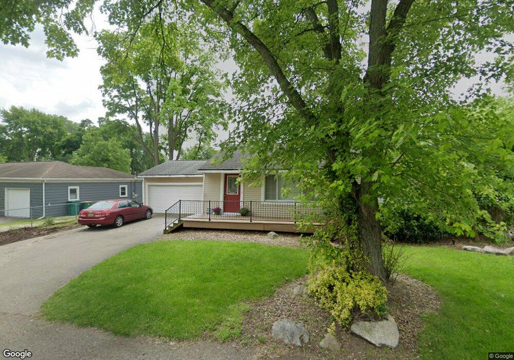
4597 Forest Ave Waterford, MI 48328
Waterford Township NeighborhoodEstimated Value: $335,000 - $597,000
3
Beds
2
Baths
1,876
Sq Ft
$257/Sq Ft
Est. Value
About This Home
This home is located at 4597 Forest Ave, Waterford, MI 48328 and is currently estimated at $481,727, approximately $256 per square foot. 4597 Forest Ave is a home located in Oakland County with nearby schools including Cooley Elementary School, Pierce Middle School, and Waterford Kettering High School.
Ownership History
Date
Name
Owned For
Owner Type
Purchase Details
Closed on
Nov 18, 2024
Sold by
Warmelink Roger A
Bought by
Warmelink Roger A
Current Estimated Value
Purchase Details
Closed on
Apr 3, 2002
Sold by
Gonzalez Lori L
Bought by
Warmelink Roger A
Purchase Details
Closed on
Aug 4, 1997
Sold by
Zajac James W
Bought by
Warmelink Roger A
Home Financials for this Owner
Home Financials are based on the most recent Mortgage that was taken out on this home.
Original Mortgage
$132,000
Interest Rate
7.68%
Create a Home Valuation Report for This Property
The Home Valuation Report is an in-depth analysis detailing your home's value as well as a comparison with similar homes in the area
Home Values in the Area
Average Home Value in this Area
Purchase History
| Date | Buyer | Sale Price | Title Company |
|---|---|---|---|
| Warmelink Roger A | -- | None Listed On Document | |
| Warmelink Roger A | -- | None Listed On Document | |
| Warmelink Roger A | -- | None Listed On Document | |
| Warmelink Roger A | -- | -- | |
| Warmelink Roger A | $165,000 | -- |
Source: Public Records
Mortgage History
| Date | Status | Borrower | Loan Amount |
|---|---|---|---|
| Previous Owner | Warmelink Roger A | $132,000 |
Source: Public Records
Tax History Compared to Growth
Tax History
| Year | Tax Paid | Tax Assessment Tax Assessment Total Assessment is a certain percentage of the fair market value that is determined by local assessors to be the total taxable value of land and additions on the property. | Land | Improvement |
|---|---|---|---|---|
| 2024 | $2,930 | $244,580 | $0 | $0 |
| 2023 | $2,795 | $227,130 | $0 | $0 |
| 2022 | $4,704 | $211,580 | $0 | $0 |
| 2021 | $4,466 | $196,530 | $0 | $0 |
| 2020 | $2,493 | $193,030 | $0 | $0 |
| 2019 | $4,678 | $181,430 | $0 | $0 |
| 2018 | $4,307 | $145,760 | $0 | $0 |
| 2017 | $3,984 | $145,760 | $0 | $0 |
| 2016 | $4,645 | $136,350 | $0 | $0 |
| 2015 | -- | $120,350 | $0 | $0 |
| 2014 | -- | $112,800 | $0 | $0 |
| 2011 | -- | $102,990 | $0 | $0 |
Source: Public Records
Map
Nearby Homes
- 4741 Maycrest Dr
- 1727 Crescent Lake Rd
- 4255 Lakewood Dr
- 4241 S Shore St
- 2164 Georgeland Dr
- 1358 Hillcrest Dr Unit 4
- 4040 Lark Ave
- 2190 Crescent Lake Rd
- 4073 Silver Birch Dr
- 4935 Pontiac Lake Rd
- 1225 Eason
- 1360 Nancywood Dr
- 867 Saybrook Dr
- 5357 Farm Rd
- 1620 Irwin Dr
- 5251 Pontiac Lake Rd
- 1249 Woodlow St
- 3633 Richmond St
- 2358 Highfield Rd
- 4170 Edmore Rd
- 4607 Forest Ave
- 4589 Forest Ave
- 4583 Forest Ave Unit Bldg-Unit
- 4583 Forest Ave
- 4631 Forest Ave
- 4600 Forest Ave
- 4577 Forest Ave
- 0 Sedum Glen Unit 5590851
- 0 Sedum Glen Unit 217040793
- 4584 Forest Ave
- 4610 Forest Ave
- 4641 Forest Ave
- 4571 Forest Ave
- 0 Forest Ave Unit 218038758
- 0 Forest Unit 4922657
- 0 Forest Unit 4919325
- 0 Forest Unit 4919892
- 0 Forest Unit 4973808
- 0 Forest Unit 865793
- 0 Forest Unit 5590806