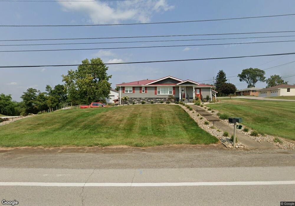
4599 State Route 151 Mingo Junction, OH 43938
Estimated Value: $127,000 - $218,000
3
Beds
2
Baths
1,188
Sq Ft
$136/Sq Ft
Est. Value
About This Home
This home is located at 4599 State Route 151, Mingo Junction, OH 43938 and is currently estimated at $162,064, approximately $136 per square foot. 4599 State Route 151 is a home with nearby schools including Buckeye Local High School.
Ownership History
Date
Name
Owned For
Owner Type
Purchase Details
Closed on
Jul 3, 2023
Sold by
Patricia M Bell 0/2022 Irrevocable T
Bought by
Kish Daniel
Current Estimated Value
Purchase Details
Closed on
Apr 14, 2008
Sold by
Watson Carol L
Bought by
Soltis Edward F
Home Financials for this Owner
Home Financials are based on the most recent Mortgage that was taken out on this home.
Original Mortgage
$101,605
Interest Rate
5.88%
Create a Home Valuation Report for This Property
The Home Valuation Report is an in-depth analysis detailing your home's value as well as a comparison with similar homes in the area
Purchase History
| Date | Buyer | Sale Price | Title Company |
|---|---|---|---|
| Kish Daniel | -- | None Listed On Document | |
| Kish Daniel | -- | None Listed On Document | |
| Soltis Edward F | -- | -- |
Source: Public Records
Mortgage History
| Date | Status | Borrower | Loan Amount |
|---|---|---|---|
| Previous Owner | Soltis Edward F | $101,605 | |
| Previous Owner | Soltis Edward F | $101,605 |
Source: Public Records
Tax History
| Year | Tax Paid | Tax Assessment Tax Assessment Total Assessment is a certain percentage of the fair market value that is determined by local assessors to be the total taxable value of land and additions on the property. | Land | Improvement |
|---|---|---|---|---|
| 2025 | $2,342 | $41,048 | $3,066 | $37,982 |
| 2024 | $1,496 | $41,048 | $3,066 | $37,982 |
| 2023 | $1,493 | $33,632 | $3,413 | $30,219 |
| 2022 | $1,307 | $33,632 | $3,413 | $30,219 |
| 2021 | $1,307 | $33,632 | $3,413 | $30,219 |
| 2020 | $1,333 | $33,524 | $3,413 | $30,111 |
| 2019 | $1,260 | $0 | $0 | $0 |
| 2018 | $1,154 | $0 | $0 | $0 |
| 2017 | $1,298 | $0 | $0 | $0 |
| 2016 | $1,339 | $0 | $0 | $0 |
| 2015 | $1,254 | $0 | $0 | $0 |
| 2014 | $1,183 | $0 | $0 | $0 |
| 2012 | $558 | $34,230 | $3,745 | $30,485 |
Source: Public Records
Map
Nearby Homes
- 329 Township Road 177
- 115 Township Road 501
- 1205 Hukill St
- 707 4th St
- 215 Isabelle St
- 810 3rd St
- 126 Ohio St
- 208 Jefferson Blvd
- 4351 County Road 17
- 2309 Commercial Ave
- 141 West Blvd
- 2021 Commercial St
- 2404 Main St
- 2010 Marianna St
- 1922 Marianna St
- 2200 Main St
- 102 Valley Rd
- 116 Vine St
- 0 Hill School Rd
- 1451 Main St
- 4533 State Route 151
- 4523 State Route 151
- 4575 State Route 151
- 151 Sr
- 4501 State Route 151
- 4594 State Route 151
- 4500 State Route 151
- 4627 State Route 151
- 4627 St R 151
- 4478 State Route 151
- 4516 State Route 151
- 4522 State Route 151
- 151 Sr
- 4438 State Route 151
- 4725 State Route 151
- 4751 State Route 151
- 4764 State Route 151
- 4788 State Route 151
- 4773 State Route 151
- 4795 State Route 151
Your Personal Tour Guide
Ask me questions while you tour the home.