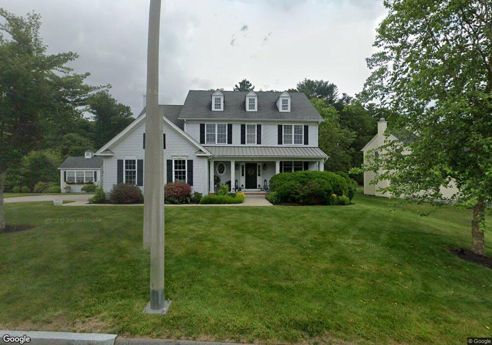
46 Anderson Way East Walpole, MA 02032
Estimated Value: $1,100,559 - $1,543,000
4
Beds
3
Baths
2,529
Sq Ft
$519/Sq Ft
Est. Value
About This Home
This home is located at 46 Anderson Way, East Walpole, MA 02032 and is currently estimated at $1,313,390, approximately $519 per square foot. 46 Anderson Way is a home with nearby schools including Fisher School, Walpole Middle School, and Walpole High School.
Ownership History
Date
Name
Owned For
Owner Type
Purchase Details
Closed on
Sep 10, 2021
Sold by
Manning Catherine A and Manning Richard L
Bought by
R Lange Manning Jr Lt
Current Estimated Value
Purchase Details
Closed on
Oct 23, 2012
Sold by
Birds Lp Est
Bought by
Manning Richard L and Manning Catherine A
Home Financials for this Owner
Home Financials are based on the most recent Mortgage that was taken out on this home.
Original Mortgage
$119,500
Interest Rate
3.57%
Mortgage Type
New Conventional
Create a Home Valuation Report for This Property
The Home Valuation Report is an in-depth analysis detailing your home's value as well as a comparison with similar homes in the area
Home Values in the Area
Average Home Value in this Area
Purchase History
| Date | Buyer | Sale Price | Title Company |
|---|---|---|---|
| R Lange Manning Jr Lt | -- | None Available | |
| Manning Richard L | $650,338 | -- |
Source: Public Records
Mortgage History
| Date | Status | Borrower | Loan Amount |
|---|---|---|---|
| Previous Owner | Manning Richard L | $119,500 |
Source: Public Records
Tax History Compared to Growth
Tax History
| Year | Tax Paid | Tax Assessment Tax Assessment Total Assessment is a certain percentage of the fair market value that is determined by local assessors to be the total taxable value of land and additions on the property. | Land | Improvement |
|---|---|---|---|---|
| 2025 | $12,971 | $1,011,000 | $409,700 | $601,300 |
| 2024 | $12,534 | $948,100 | $393,800 | $554,300 |
| 2023 | $12,433 | $895,100 | $342,500 | $552,600 |
| 2022 | $10,657 | $737,000 | $305,900 | $431,100 |
| 2021 | $10,544 | $710,500 | $288,500 | $422,000 |
| 2020 | $10,156 | $677,500 | $272,200 | $405,300 |
| 2019 | $9,798 | $648,900 | $261,800 | $387,100 |
| 2018 | $9,562 | $626,200 | $252,400 | $373,800 |
| 2017 | $9,295 | $606,300 | $242,700 | $363,600 |
| 2016 | $9,291 | $597,100 | $250,600 | $346,500 |
| 2015 | $9,084 | $578,600 | $238,700 | $339,900 |
| 2014 | $9,062 | $575,000 | $255,200 | $319,800 |
Source: Public Records
Map
Nearby Homes
- 22 Coolidge Rd
- 7 Washington Green
- 20 Rockhill St
- 20 Rockhill St
- 363 - 367 Washington St
- 531 Walpole St
- 0 Charlotte Rd
- 11 Park Ln
- 291 Plimpton St
- Unit 11 Powder House Ln Unit 11
- 8 Powder House Ln Unit 2
- Unit 12 Powder House Ln Unit 12
- Unit 3 Powder House Ln Unit 3
- 486 Washington St
- 70 Endicott St Unit 404
- 70 Endicott St Unit 1306
- 66 Gould St
- 34 Austin St Unit 1L
- 2 Alexandra Way
- 5 Atwood Ave
- 50 Anderson Dr
- 0000 Hound Pack Cir
- 00 Hound Pack Cir
- 42 Anderson Way
- 54 Anderson Way
- 54 Anderson Way
- 3 York Cir
- 00 York Cir
- 4 York Cir
- 3 Hound Pack Cir
- 58 Anderson Way
- 39 Anderson Way
- 30 Anderson Way
- 30 Anderson Dr Unit 87
- 8 York Cir
- 7 York Cir
- 0 Hound Pack Cir
- 62 Anderson Way
- 37 Anderson Way
- 22 Anderson Way