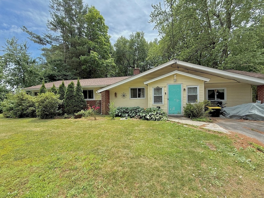
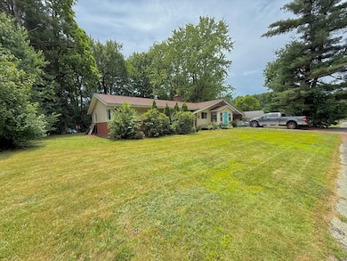
46 Barry Rd Worcester, MA 01609
Forest Grove NeighborhoodEstimated payment $2,075/month
Highlights
- Ranch Style House
- No HOA
- Gravity Heating System
- 1 Fireplace
- Enclosed Patio or Porch
About This Home
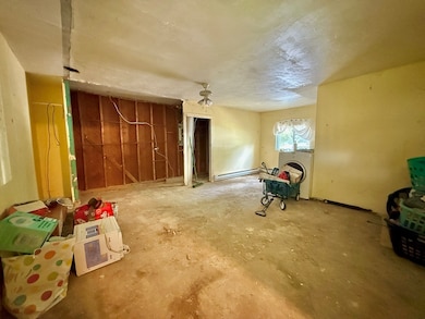
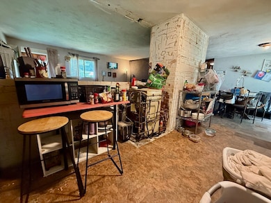
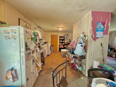
Discover the potential of this single-level ranch, ideally located in Worcester’s desirable 01609 area, near the Salisbury Street neighborhood. Set in a well-established community, this property offers a solid foundation for renovation or redevelopment. The home features a functional layout and a roof replacement completed in 2020. This is a great opportunity for those looking to customize a home to their needs or add value through updates. The property is being sold as-is, making it well-suited for buyers, investors, and contractors ready to take on a project. Conveniently located near local amenities, schools, parks, and major commuter routes, this home offers excellent accessibility for a variety of future uses. Whether you're planning to renovate and occupy, flip, or hold as an investment, this property presents a unique opportunity. *Offers due Monday by 5:00pm.
Home Details
Home Type
- Single Family
Est. Annual Taxes
- $4,723
Year Built
- Built in 1958
Lot Details
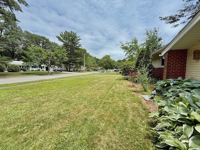
- 15,000 Sq Ft Lot
- Property is zoned RS-10
Home Design
- Manufactured Home on a slab
- Ranch Style House
Interior Spaces
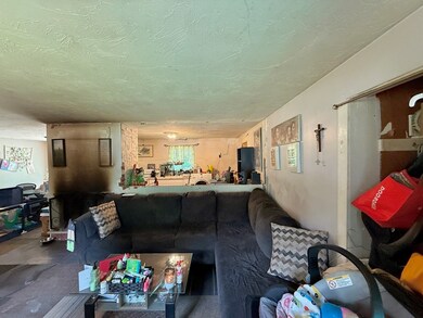
- 1,190 Sq Ft Home
- 1 Fireplace
Bedrooms and Bathrooms
- 3 Bedrooms
Parking
- 2 Car Parking Spaces
- Driveway
- Paved Parking
- 2 Open Parking Spaces
Outdoor Features
- Enclosed Patio or Porch
Schools
- Flagg Street Elementary School
- Forest Grove Middle School
- Doherty High School
Utilities
- No Cooling
- Heating System Uses Oil
- Gravity Heating System
Community Details
- No Home Owners Association
Listing and Financial Details
- Assessor Parcel Number M:55 B:013 L:00068,1805657
Map
Home Values in the Area
Average Home Value in this Area
Tax History
| Year | Tax Paid | Tax Assessment Tax Assessment Total Assessment is a certain percentage of the fair market value that is determined by local assessors to be the total taxable value of land and additions on the property. | Land | Improvement |
|---|---|---|---|---|
| 2025 | $4,723 | $358,100 | $123,800 | $234,300 |
| 2024 | $4,638 | $337,300 | $123,800 | $213,500 |
| 2023 | $4,458 | $310,900 | $106,600 | $204,300 |
| 2022 | $3,949 | $259,600 | $85,300 | $174,300 |
| 2021 | $3,792 | $232,900 | $68,200 | $164,700 |
| 2020 | $3,652 | $214,800 | $68,000 | $146,800 |
| 2019 | $3,515 | $195,300 | $65,700 | $129,600 |
| 2018 | $3,430 | $181,400 | $65,700 | $115,700 |
| 2017 | $3,463 | $180,200 | $65,700 | $114,500 |
| 2016 | $3,467 | $168,200 | $54,500 | $113,700 |
| 2015 | $3,376 | $168,200 | $54,500 | $113,700 |
| 2014 | $3,335 | $170,700 | $54,500 | $116,200 |
Property History
| Date | Event | Price | List to Sale | Price per Sq Ft |
|---|---|---|---|---|
| 07/08/2025 07/08/25 | Pending | -- | -- | -- |
| 06/30/2025 06/30/25 | For Sale | $315,000 | -- | $265 / Sq Ft |
Purchase History
| Date | Type | Sale Price | Title Company |
|---|---|---|---|
| Personal Reps Deed | -- | None Available | |
| Personal Reps Deed | -- | None Available | |
| Deed | $172,500 | -- | |
| Deed | $118,250 | -- |
Mortgage History
| Date | Status | Loan Amount | Loan Type |
|---|---|---|---|
| Previous Owner | $138,000 | Purchase Money Mortgage | |
| Previous Owner | $6,000 | No Value Available | |
| Previous Owner | $116,558 | Purchase Money Mortgage |
Source: MLS Property Information Network (MLS PIN)
MLS Number: 73398429
APN: WORC-000055-000013-000068
Disclaimer: Certain information contained herein is derived from information provided by parties other than Homes.com. All information provided is deemed reliable, but is not guaranteed to be accurate and should be independently verified.
![]() The property listing data and information, or the Images, set forth herein were provided to MLS Property Information Network, Inc. from third party sources, including sellers, lessors and public records, and were compiled by MLS Property Information Network, Inc. The property listing data and information, and the Images, are for the personal, non-commercial use of consumers having a good faith interest in purchasing or leasing listed properties of the type displayed to them and may not be used for any purpose other than to identify prospective properties which such consumers may have a good faith interest in purchasing or leasing. MLS Property Information Network, Inc. and its subscribers disclaim any and all representations and warranties as to the accuracy of the property listing data and information, or as to the accuracy of any of the Images, set forth herein.
The property listing data and information, or the Images, set forth herein were provided to MLS Property Information Network, Inc. from third party sources, including sellers, lessors and public records, and were compiled by MLS Property Information Network, Inc. The property listing data and information, and the Images, are for the personal, non-commercial use of consumers having a good faith interest in purchasing or leasing listed properties of the type displayed to them and may not be used for any purpose other than to identify prospective properties which such consumers may have a good faith interest in purchasing or leasing. MLS Property Information Network, Inc. and its subscribers disclaim any and all representations and warranties as to the accuracy of the property listing data and information, or as to the accuracy of any of the Images, set forth herein.
- 61 Barry Rd
- 770 Salisbury St Unit 424
- 697 Salisbury St
- 4004 Brompton Cir
- 3901 Knightsbridge Close Unit 3901
- 7 Primmett Ln
- 6 Barrows Rd
- 84 Chester St
- 158 Chester St
- 90 Bjorklund Ave
- 97 Parkton Ave
- 7 Tideswell Ln Unit 7
- 8 Salisbury Hill Blvd Unit 79
- 16 Baiting Brook Ln Unit 64
- 14 Baiting Brook Ln Unit 65
- 10 Baiting Brook Ln Unit 67
- 5 Chartwell Ln Unit 87
- 25 Chester St
- 23 Leslie Rd
- 15 Dennison Rd

Ask me questions while you tour the home.