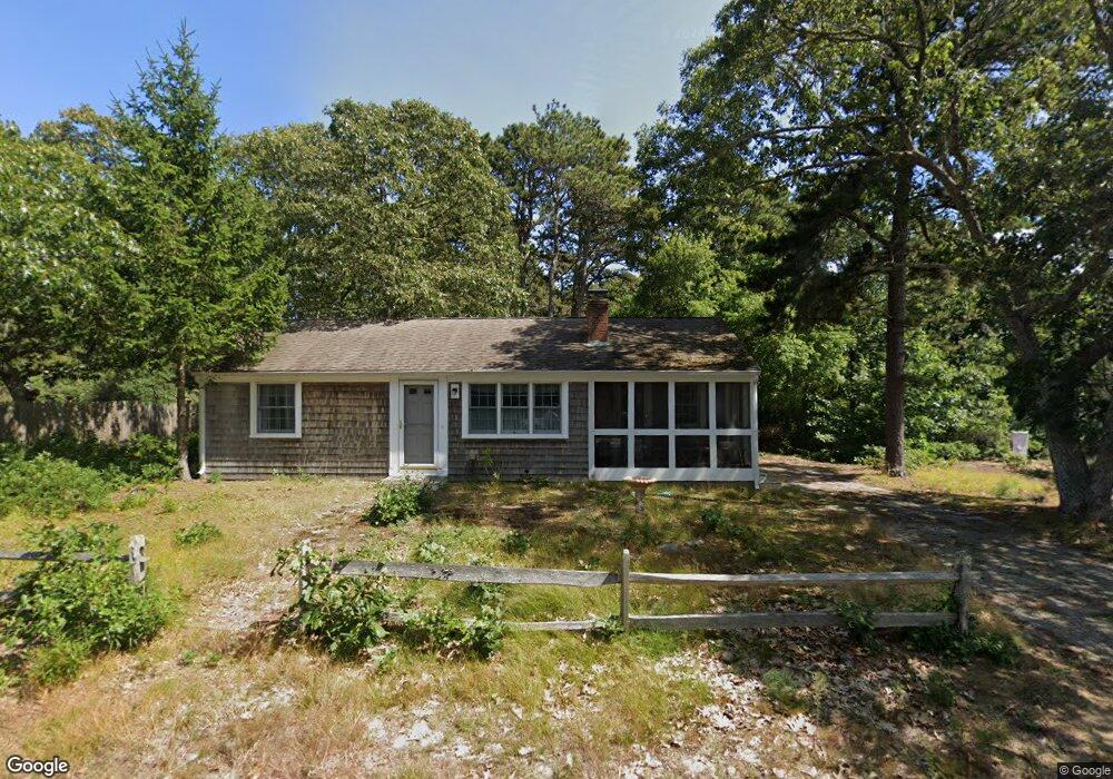
46 Beach Plum Ln Dennis Port, MA 02639
Dennis Port NeighborhoodEstimated Value: $442,000 - $610,000
3
Beds
1
Bath
828
Sq Ft
$655/Sq Ft
Est. Value
About This Home
This home is located at 46 Beach Plum Ln, Dennis Port, MA 02639 and is currently estimated at $542,144, approximately $654 per square foot. 46 Beach Plum Ln is a home located in Barnstable County with nearby schools including Dennis-Yarmouth Regional High School and St. Pius X. School.
Ownership History
Date
Name
Owned For
Owner Type
Purchase Details
Closed on
May 10, 2025
Sold by
Donohue Karen N and Peach Suzanne L
Bought by
46 Beach Plum Ln Nt and Donohue
Current Estimated Value
Create a Home Valuation Report for This Property
The Home Valuation Report is an in-depth analysis detailing your home's value as well as a comparison with similar homes in the area
Home Values in the Area
Average Home Value in this Area
Purchase History
| Date | Buyer | Sale Price | Title Company |
|---|---|---|---|
| 46 Beach Plum Ln Nt | -- | None Available | |
| 46 Beach Plum Ln Nt | -- | None Available | |
| Donohue Karen N | -- | None Available | |
| Donohue Karen N | -- | None Available |
Source: Public Records
Tax History Compared to Growth
Tax History
| Year | Tax Paid | Tax Assessment Tax Assessment Total Assessment is a certain percentage of the fair market value that is determined by local assessors to be the total taxable value of land and additions on the property. | Land | Improvement |
|---|---|---|---|---|
| 2025 | $1,997 | $461,200 | $184,500 | $276,700 |
| 2024 | $1,849 | $421,200 | $177,500 | $243,700 |
| 2023 | $1,789 | $383,000 | $161,300 | $221,700 |
| 2022 | $1,724 | $307,800 | $145,300 | $162,500 |
| 2021 | $125 | $275,500 | $142,500 | $133,000 |
| 2020 | $126 | $262,400 | $131,500 | $130,900 |
| 2019 | $0 | $247,900 | $129,000 | $118,900 |
| 2018 | $121 | $242,100 | $133,000 | $109,100 |
| 2017 | $1,405 | $228,400 | $122,800 | $105,600 |
| 2016 | $1,422 | $217,800 | $127,900 | $89,900 |
| 2015 | $1,394 | $217,800 | $127,900 | $89,900 |
| 2014 | $1,285 | $202,400 | $112,500 | $89,900 |
Source: Public Records
Map
Nearby Homes
- 22 Wixon Rd
- 31 Easy St
- 72 Bassett Ln
- 22 Ferncliff Rd
- 102 Sea St
- 268 Main St
- 19 Standish Way
- 37-A Beach Hills Rd
- 37 Beach Hills Rd
- 12 Cross St
- 4 Coffey Ln
- 125 Main St Unit 3
- 262 Old Wharf Rd Unit 67
- 262 Old Wharf Rd Unit 5
- 262 Old Wharf Rd Unit 5
- 262 Old Wharf Rd Unit 20
- 262 Old Wharf Rd Unit 87
- 10 Candlewood Ln Unit 2-1
- 42 Beach Plum Ln
- 52 Beach Plum Ln
- 39 Beach Plum Ln
- 43 Beach Plum Ln
- 33 Beach Plum Ln
- 38 Beach Plum Ln
- 56 Beach Plum Ln
- 47 Beach Plum Ln
- 40 Blueberry Ln
- 36 Blueberry Ln
- 31 Beach Plum Ln
- 32 Blueberry Ln
- 34 Beach Plum Ln
- 60 Beach Plum Ln
- 28 Blueberry Ln
- 27 Beach Plum Ln
- 27 Beachplum Ln
- 33 Blueberry Ln
- 29 Blueberry Ln
- 24 Blueberry Ln