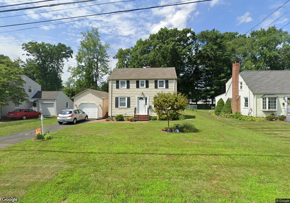
46 Brace Rd Newington, CT 06111
Estimated Value: $315,000 - $348,199
2
Beds
2
Baths
1,366
Sq Ft
$243/Sq Ft
Est. Value
About This Home
This home is located at 46 Brace Rd, Newington, CT 06111 and is currently estimated at $331,800, approximately $242 per square foot. 46 Brace Rd is a home located in Hartford County with nearby schools including Elizabeth Green School, Martin Kellogg Middle School, and Newington High School.
Ownership History
Date
Name
Owned For
Owner Type
Purchase Details
Closed on
Feb 27, 2013
Sold by
Tessitore Elizabeth P and Pitruzzello Mario
Bought by
Tessitore Elizabeth P
Current Estimated Value
Home Financials for this Owner
Home Financials are based on the most recent Mortgage that was taken out on this home.
Original Mortgage
$173,500
Outstanding Balance
$104,136
Interest Rate
3.43%
Estimated Equity
$227,664
Purchase Details
Closed on
Jul 31, 2007
Sold by
Hill Judith A
Bought by
Pitruzzello Elizabeth M and Pitruzzello Mario
Create a Home Valuation Report for This Property
The Home Valuation Report is an in-depth analysis detailing your home's value as well as a comparison with similar homes in the area
Home Values in the Area
Average Home Value in this Area
Purchase History
| Date | Buyer | Sale Price | Title Company |
|---|---|---|---|
| Tessitore Elizabeth P | -- | -- | |
| Pitruzzello Elizabeth M | $195,000 | -- |
Source: Public Records
Mortgage History
| Date | Status | Borrower | Loan Amount |
|---|---|---|---|
| Open | Tessitore Elizabeth P | $173,500 | |
| Previous Owner | Pitruzzello Elizabeth M | $171,500 | |
| Previous Owner | Pitruzzello Elizabeth M | $20,000 |
Source: Public Records
Tax History Compared to Growth
Tax History
| Year | Tax Paid | Tax Assessment Tax Assessment Total Assessment is a certain percentage of the fair market value that is determined by local assessors to be the total taxable value of land and additions on the property. | Land | Improvement |
|---|---|---|---|---|
| 2025 | $5,784 | $144,660 | $55,440 | $89,220 |
| 2024 | $5,534 | $139,500 | $55,440 | $84,060 |
| 2023 | $5,672 | $147,870 | $55,440 | $92,430 |
| 2022 | $5,692 | $147,870 | $55,440 | $92,430 |
| 2021 | $5,739 | $147,870 | $55,440 | $92,430 |
| 2020 | $5,463 | $139,070 | $51,980 | $87,090 |
| 2019 | $5,486 | $139,070 | $51,980 | $87,090 |
| 2018 | $5,354 | $139,070 | $51,980 | $87,090 |
| 2017 | $5,089 | $139,070 | $51,980 | $87,090 |
| 2016 | $4,972 | $139,070 | $51,980 | $87,090 |
| 2014 | $4,848 | $139,420 | $52,280 | $87,140 |
Source: Public Records
Map
Nearby Homes
- 29 Sunnyside Rd
- 263 Williamstown Ct
- 131 Williamstown Ct Unit 131
- 559 Mountain Rd
- 47 Francis Dr
- 161 Abbotsford Ave
- 93 Marion St Unit 3
- 90 Meriline Ave
- 127 Hollywood Ave
- 121 Cambridge St
- 43 Marion St
- 93 Stanwood St
- 41 Page Ave
- 148 Colonial St
- 20 Surrey Dr Unit B16 aka B4
- 37 Commonwealth Ave
- 937 New Britain Ave
- 27 Harding Ave
- 35 Harding Ave
- 140 Camp Ave