


46 Chase Rd East Sandwich, MA 02537
Estimated payment $3,591/month
Highlights
- Medical Services
- Wood Flooring
- No HOA
- Deck
- 1 Fireplace
- Balcony
About This Home
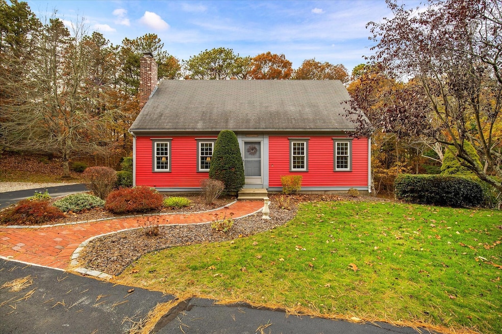
This beautiful Cape is perched on a private lot at the end of a long drive and is a short drive to the Mid-Cape Highway, making for convenient commuting. With a detached 2-car garage and an additional garage bay under, you'll have plenty of room for cars and beach/yard gear. The lower-level garage is perfect for a workshop or as a staging area for outdoor gatherings. Mature plantings, flower gardens, and a picturesque brick walkway create an abundance of curb appeal. Around back, you'll find a vast, maintenance-free, multi-level deck with an awning. The first level features an open kitchen/sitting room with a fireplace/wood stove, a large front-to-back living/dining room, and a 1/2 bath. On the 2nd level are two large bedrooms and a full bath. One bedroom has a walk-in closet and a slider that opens to a small balcony overlooking the rear yard. In the lower level, you'll find ample finished space that can be used as a third bedroom or a playroom. There's also a bath with a stand-up shower. This space opens to the lower-level garage/ shop space and is a walk-out. There are new tilt-in replacement windows and a slider. Pride of ownership shines through--make it your own!
Home Details
Home Type
- Single Family
Est. Annual Taxes
- $5,216
Year Built
- Built in 1986 | Remodeled
Lot Details
- 0.63 Acre Lot
- Cleared Lot
- Property is zoned RIDGE
Parking
- 2 Car Garage
- Open Parking
Home Design
- Poured Concrete
- Pitched Roof
- Shingle Roof
- Asphalt Roof
- Shingle Siding
- Concrete Perimeter Foundation
- Clapboard
Interior Spaces
- 1,887 Sq Ft Home
- 2-Story Property
- 1 Fireplace
- Sliding Doors
- Living Room
- Washer
Kitchen
- Electric Range
- Microwave
- Dishwasher
Flooring
- Wood
- Carpet
- Tile
- Vinyl
Bedrooms and Bathrooms
- 3 Bedrooms
- Primary bedroom located on second floor
- Linen Closet
- Walk-In Closet
Finished Basement
- Basement Fills Entire Space Under The House
- Interior Basement Entry
Outdoor Features
- Balcony
- Deck
Location
- Property is near place of worship
- Property is near shops
- Property is near a golf course
Utilities
- No Cooling
- Heating Available
- Well
- Electric Water Heater
- Septic Tank
Listing and Financial Details
- Assessor Parcel Number SAND M:0025 B:0067
Community Details
Overview
- No Home Owners Association
- Near Conservation Area
Amenities
- Medical Services
Recreation
- Bike Trail
Map
Home Values in the Area
Average Home Value in this Area
Tax History
| Year | Tax Paid | Tax Assessment Tax Assessment Total Assessment is a certain percentage of the fair market value that is determined by local assessors to be the total taxable value of land and additions on the property. | Land | Improvement |
|---|---|---|---|---|
| 2025 | $5,216 | $493,500 | $144,300 | $349,200 |
| 2024 | $4,966 | $459,800 | $128,800 | $331,000 |
| 2023 | $4,824 | $419,500 | $117,100 | $302,400 |
| 2022 | $4,821 | $366,300 | $122,700 | $243,600 |
| 2021 | $2,605 | $337,600 | $118,000 | $219,600 |
| 2020 | $4,666 | $326,100 | $117,800 | $208,300 |
| 2019 | $4,728 | $330,200 | $134,900 | $195,300 |
| 2018 | $2,538 | $305,600 | $124,100 | $181,500 |
| 2017 | $2,471 | $289,400 | $120,100 | $169,300 |
| 2016 | $4,107 | $283,800 | $118,900 | $164,900 |
| 2015 | $4,225 | $285,100 | $123,200 | $161,900 |
Property History
| Date | Event | Price | List to Sale | Price per Sq Ft |
|---|---|---|---|---|
| 11/19/2025 11/19/25 | Pending | -- | -- | -- |
| 11/07/2025 11/07/25 | For Sale | $600,000 | -- | $318 / Sq Ft |
Purchase History
| Date | Type | Sale Price | Title Company |
|---|---|---|---|
| Quit Claim Deed | -- | -- | |
| Quit Claim Deed | -- | -- | |
| Deed | $97,000 | -- | |
| Foreclosure Deed | $98,000 | -- |
Mortgage History
| Date | Status | Loan Amount | Loan Type |
|---|---|---|---|
| Previous Owner | $205,000 | No Value Available | |
| Previous Owner | $125,000 | No Value Available |
Source: Cape Cod & Islands Association of REALTORS®
MLS Number: 22505556
APN: SAND-000025-000067
Disclaimer: Certain information contained herein is derived from information provided by parties other than Homes.com. All information provided is deemed reliable, but is not guaranteed to be accurate and should be independently verified.
![]() All data relating to real estate for sale on this page comes from the Broker Reciprocity (BR) of the Cape Cod & Islands Multiple Listing Service, Inc. Detailed information about real estate listings held by brokerage firms other than CC&I Assoc. of REALTORS®, Inc. includes the name of the listing company. Neither the listing company nor CC&I Assoc. of REALTORS®, Inc. shall be responsible for any typographical errors, misinformation, misprints and shall be held totally harmless. The Broker providing this data believes it to be correct, but advises interested parties to confirm any item before relying on it in a purchase decision. All properties are subject to prior sale, changes, or withdrawal. Copyright 2025 © Cape Cod & Islands Multiple Listing Service, Inc. All rights reserved.
All data relating to real estate for sale on this page comes from the Broker Reciprocity (BR) of the Cape Cod & Islands Multiple Listing Service, Inc. Detailed information about real estate listings held by brokerage firms other than CC&I Assoc. of REALTORS®, Inc. includes the name of the listing company. Neither the listing company nor CC&I Assoc. of REALTORS®, Inc. shall be responsible for any typographical errors, misinformation, misprints and shall be held totally harmless. The Broker providing this data believes it to be correct, but advises interested parties to confirm any item before relying on it in a purchase decision. All properties are subject to prior sale, changes, or withdrawal. Copyright 2025 © Cape Cod & Islands Multiple Listing Service, Inc. All rights reserved.
- 6 Harpers Hollow
- 14 Village Dr
- 159 Great Hill Rd
- 718 Cedar St
- 50 Wayside Ln
- 75 Old Toll Rd
- 7 Highfield Dr
- 515 Cedar St
- 510 Cedar St
- 665 Route 6a
- 507 Massachusetts 6a Unit 9
- 3 Mulberry Cir
- 0 Captain Kidd Rd
- 23 Old Fields Rd
- 2 Marie Ln
- 420 Massachusetts 6a
- 9 Crestview Drive Extension
- 49 Atkins Rd
- 49 Atkins Rd
- 20 Crestview Dr
