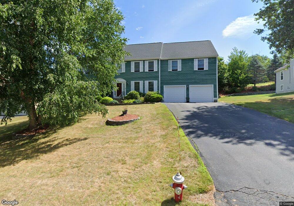
46 Elliot Trail Grafton, MA 01519
Estimated Value: $867,000 - $900,000
4
Beds
4
Baths
2,888
Sq Ft
$307/Sq Ft
Est. Value
About This Home
This home is located at 46 Elliot Trail, Grafton, MA 01519 and is currently estimated at $885,325, approximately $306 per square foot. 46 Elliot Trail is a home located in Worcester County with nearby schools including Grafton High School and Silver Spruce Montessori School.
Ownership History
Date
Name
Owned For
Owner Type
Purchase Details
Closed on
Jun 18, 2010
Sold by
Ing Bk
Bought by
Katyal Satish and Katyal Sunita
Current Estimated Value
Purchase Details
Closed on
Jan 4, 2010
Sold by
Griffin Marvin and Ing Bk
Bought by
Ing Bk
Purchase Details
Closed on
Sep 1, 2005
Sold by
Mastrianni John A and Mastrianni Kimberly S
Bought by
Griffin Marvin and Huda Yasmin
Purchase Details
Closed on
Aug 27, 2003
Sold by
Tanzi Michael S and Tanzi Pamela J
Bought by
Mastrianni John A and Mastrianni Kimberly S
Purchase Details
Closed on
Sep 3, 1999
Sold by
Pheasant Hill Realty
Bought by
Tanzi Michael S and Tanzi Pamela J
Create a Home Valuation Report for This Property
The Home Valuation Report is an in-depth analysis detailing your home's value as well as a comparison with similar homes in the area
Home Values in the Area
Average Home Value in this Area
Purchase History
| Date | Buyer | Sale Price | Title Company |
|---|---|---|---|
| Katyal Satish | $382,000 | -- | |
| Katyal Satish | $382,000 | -- | |
| Katyal Satish | $382,000 | -- | |
| Ing Bk | $445,900 | -- | |
| Ing Bk | $445,900 | -- | |
| Ing Bk | $445,900 | -- | |
| Griffin Marvin | $565,000 | -- | |
| Griffin Marvin | $565,000 | -- | |
| Griffin Marvin | $565,000 | -- | |
| Mastrianni John A | $476,000 | -- | |
| Mastrianni John A | $476,000 | -- | |
| Mastrianni John A | $476,000 | -- | |
| Tanzi Michael S | $323,200 | -- | |
| Tanzi Michael S | $323,200 | -- |
Source: Public Records
Mortgage History
| Date | Status | Borrower | Loan Amount |
|---|---|---|---|
| Open | Tanzi Michael S | $92,000 | |
| Open | Tanzi Michael S | $352,000 |
Source: Public Records
Tax History Compared to Growth
Tax History
| Year | Tax Paid | Tax Assessment Tax Assessment Total Assessment is a certain percentage of the fair market value that is determined by local assessors to be the total taxable value of land and additions on the property. | Land | Improvement |
|---|---|---|---|---|
| 2025 | $10,624 | $762,100 | $178,200 | $583,900 |
| 2024 | $10,426 | $728,600 | $178,700 | $549,900 |
| 2023 | $9,522 | $606,100 | $178,700 | $427,400 |
| 2022 | $8,850 | $524,300 | $153,400 | $370,900 |
| 2021 | $8,762 | $510,000 | $139,500 | $370,500 |
| 2020 | $8,366 | $507,000 | $139,500 | $367,500 |
| 2019 | $8,162 | $489,900 | $135,500 | $354,400 |
| 2018 | $7,598 | $458,000 | $134,400 | $323,600 |
| 2017 | $7,350 | $448,200 | $124,600 | $323,600 |
| 2016 | $7,368 | $439,900 | $128,100 | $311,800 |
| 2015 | $7,306 | $442,800 | $128,100 | $314,700 |
| 2014 | $6,650 | $435,800 | $136,400 | $299,400 |
Source: Public Records
Map
Nearby Homes
- 54 Elliot Trail
- 151 Providence Rd Unit 15
- 151 Providence Rd Unit 24
- 49 South St
- 30 Nottingham Rd
- 36 South St
- 13 Pullard Rd Unit 38
- 42 Gordon Cir Unit 42
- 18 Pullard Rd
- 24 Coventry Rd
- 7 Pleasant St
- 3 Millbury St
- 55 Upton St
- 63 Providence Rd Unit 2
- 78 Pleasant St
- 8 Chestnut St
- 81 Millbury St
- 5 Merriam Rd
- 43 Barbara Jean St
- 18 Barbara Jean St