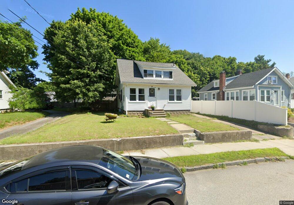
46 Gorman Rd Framingham, MA 01702
Estimated Value: $504,949 - $626,000
2
Beds
1
Bath
1,215
Sq Ft
$458/Sq Ft
Est. Value
About This Home
This home is located at 46 Gorman Rd, Framingham, MA 01702 and is currently estimated at $555,987, approximately $457 per square foot. 46 Gorman Rd is a home located in Middlesex County with nearby schools including Framingham High School, Christa McAuliffe Charter School, and Happy Hollow School.
Ownership History
Date
Name
Owned For
Owner Type
Purchase Details
Closed on
Apr 2, 1991
Sold by
Shellenberger Dorothy
Bought by
Crooker Stephen C and Crooker Diane C
Current Estimated Value
Home Financials for this Owner
Home Financials are based on the most recent Mortgage that was taken out on this home.
Original Mortgage
$118,800
Interest Rate
9.17%
Mortgage Type
Purchase Money Mortgage
Create a Home Valuation Report for This Property
The Home Valuation Report is an in-depth analysis detailing your home's value as well as a comparison with similar homes in the area
Home Values in the Area
Average Home Value in this Area
Purchase History
| Date | Buyer | Sale Price | Title Company |
|---|---|---|---|
| Crooker Stephen C | $132,000 | -- | |
| Crooker Stephen C | $132,000 | -- |
Source: Public Records
Mortgage History
| Date | Status | Borrower | Loan Amount |
|---|---|---|---|
| Open | Crooker Stephen C | $117,485 | |
| Closed | Crooker Stephen C | $118,800 |
Source: Public Records
Tax History
| Year | Tax Paid | Tax Assessment Tax Assessment Total Assessment is a certain percentage of the fair market value that is determined by local assessors to be the total taxable value of land and additions on the property. | Land | Improvement |
|---|---|---|---|---|
| 2025 | $5,027 | $421,000 | $216,100 | $204,900 |
| 2024 | $4,806 | $385,700 | $193,600 | $192,100 |
| 2023 | $4,564 | $348,700 | $173,500 | $175,200 |
| 2022 | $4,264 | $310,300 | $157,600 | $152,700 |
| 2021 | $4,146 | $295,100 | $151,500 | $143,600 |
| 2020 | $4,060 | $271,000 | $131,800 | $139,200 |
| 2019 | $3,950 | $256,800 | $128,000 | $128,800 |
| 2018 | $3,884 | $238,000 | $121,100 | $116,900 |
| 2017 | $3,837 | $229,600 | $117,700 | $111,900 |
| 2016 | $3,655 | $210,300 | $113,900 | $96,400 |
| 2015 | $3,573 | $200,500 | $112,300 | $88,200 |
Source: Public Records
Map
Nearby Homes
- 16 Grant Street Extension
- 260 Grant St
- 47 Bishop Dr
- 46 Cochituate Rd Unit 106
- 96 Mansfield St
- 56 Morency St Unit D
- 6 Woodward Rd
- 50 Kittredge Rd
- 15 Willis St Unit 4
- Lot 3 Murray Hill Rd
- 14 Ridgefield Dr
- 120 Franklin St
- 33 Stevens Rd
- 575 Union Ave Unit 1
- 18 Beaver Ct
- 126 Beaver St Unit 5
- 157 Mill St
- 21 Village Rock Ln Unit 4
- 9 Village Hill Ln Unit 15
- 5 Village Rock Ln Unit 24
Your Personal Tour Guide
Ask me questions while you tour the home.