
Seller's Agent in 2025
Nikki Milott McCay
Gibson Sotheby's International Realty
(617) 721-5452
22 in this area
71 Total Sales
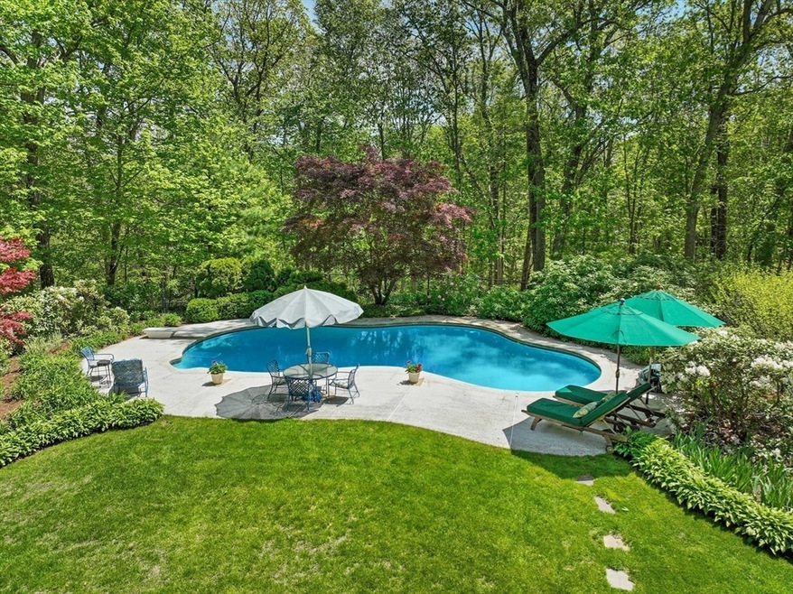
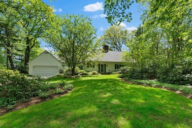
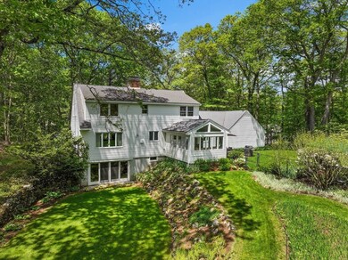
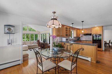
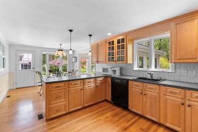
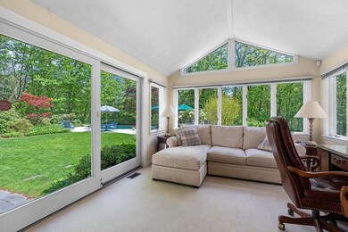
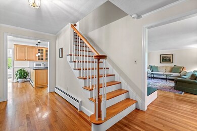
Hidden Two Acre Gem at the end of a cul-de-sac. This picture-perfect 4-bedroom, 2-bath Cape-style home is light and bright featuring terraced flowering gardens and privacy. The main level welcomes you with a spacious living room with fireplace, an inviting dining area, an eat-in kitchen, a full bath, and a sun-drenched three-season sunroom. The first-floor primary bedroom offers views of the in-ground gunite pool and the beautifully landscaped fenced-in backyard. Upstairs, you will find 3 generously sized bedrooms and another full bath. Hardwood floors run throughout the home. The finished walkout lower level with a second fireplace provides a versatile bonus space ideal for a home office, playroom or media room. Perfectly located just minutes to major highways, restaurants, and shopping, this home offers easy living in a prime location! New Central Air Conditioning System 2025.
Last Agent to Sell the Property
Gibson Sotheby's International Realty Listed on: 05/15/2025
| Date | Type | Sale Price | Title Company |
|---|---|---|---|
| Deed | $1,400,000 | -- | |
| Deed | $1,400,000 | -- | |
| Deed | -- | -- | |
| Deed | -- | -- |
| Date | Status | Loan Amount | Loan Type |
|---|---|---|---|
| Open | $700,000 | New Conventional | |
| Closed | $700,000 | New Conventional | |
| Previous Owner | $170,000 | No Value Available | |
| Previous Owner | $55,000 | No Value Available |
| Date | Event | Price | List to Sale | Price per Sq Ft |
|---|---|---|---|---|
| 09/08/2025 09/08/25 | Sold | $1,400,000 | +7.7% | $466 / Sq Ft |
| 05/19/2025 05/19/25 | Pending | -- | -- | -- |
| 05/15/2025 05/15/25 | For Sale | $1,300,000 | -- | $432 / Sq Ft |
| Year | Tax Paid | Tax Assessment Tax Assessment Total Assessment is a certain percentage of the fair market value that is determined by local assessors to be the total taxable value of land and additions on the property. | Land | Improvement |
|---|---|---|---|---|
| 2025 | $19,481 | $1,246,400 | $698,000 | $548,400 |
| 2024 | $18,424 | $1,187,100 | $664,700 | $522,400 |
| 2023 | $17,915 | $1,076,000 | $605,700 | $470,300 |
| 2022 | $17,176 | $936,000 | $504,700 | $431,300 |
| 2021 | $16,518 | $891,900 | $460,600 | $431,300 |
| 2020 | $15,840 | $891,900 | $460,600 | $431,300 |
| 2019 | $15,127 | $827,500 | $439,600 | $387,900 |
| 2018 | $5,412 | $788,300 | $439,600 | $348,700 |
| 2017 | $13,951 | $769,100 | $425,600 | $343,500 |
| 2016 | $13,002 | $749,800 | $434,700 | $315,100 |
| 2015 | $13,653 | $742,400 | $434,700 | $307,700 |
Seller's Agent in 2025
Nikki Milott McCay
Gibson Sotheby's International Realty
(617) 721-5452
22 in this area
71 Total Sales
Buyer's Agent in 2025
Kathryn Lee
Gibson Sotheby's International Realty
(978) 835-9548
2 in this area
52 Total Sales
Source: MLS Property Information Network (MLS PIN)
MLS Number: 73375824
APN: WAYL-000044-000000-000071
Disclaimer: Certain information contained herein is derived from information provided by parties other than Homes.com. All information provided is deemed reliable, but is not guaranteed to be accurate and should be independently verified.
![]() The property listing data and information, or the Images, set forth herein were provided to MLS Property Information Network, Inc. from third party sources, including sellers, lessors and public records, and were compiled by MLS Property Information Network, Inc. The property listing data and information, and the Images, are for the personal, non-commercial use of consumers having a good faith interest in purchasing or leasing listed properties of the type displayed to them and may not be used for any purpose other than to identify prospective properties which such consumers may have a good faith interest in purchasing or leasing. MLS Property Information Network, Inc. and its subscribers disclaim any and all representations and warranties as to the accuracy of the property listing data and information, or as to the accuracy of any of the Images, set forth herein.
The property listing data and information, or the Images, set forth herein were provided to MLS Property Information Network, Inc. from third party sources, including sellers, lessors and public records, and were compiled by MLS Property Information Network, Inc. The property listing data and information, and the Images, are for the personal, non-commercial use of consumers having a good faith interest in purchasing or leasing listed properties of the type displayed to them and may not be used for any purpose other than to identify prospective properties which such consumers may have a good faith interest in purchasing or leasing. MLS Property Information Network, Inc. and its subscribers disclaim any and all representations and warranties as to the accuracy of the property listing data and information, or as to the accuracy of any of the Images, set forth herein.