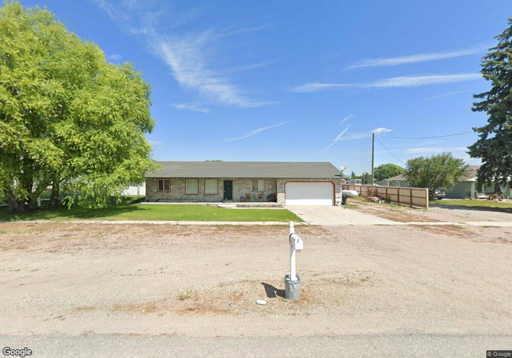
46 W 1st N Weston, ID 83286
Estimated Value: $368,000 - $401,000
3
Beds
2
Baths
1,204
Sq Ft
$317/Sq Ft
Est. Value
About This Home
This home is located at 46 W 1st N, Weston, ID 83286 and is currently estimated at $382,008, approximately $317 per square foot. 46 W 1st N is a home located in Franklin County with nearby schools including Harold B. Lee Elementary School, Harold B. Lee Middle School, and West Side Senior High School.
Ownership History
Date
Name
Owned For
Owner Type
Purchase Details
Closed on
Dec 20, 2019
Sold by
Spencer Glendon J and Spencer Barbara N
Bought by
Laird Stacy
Current Estimated Value
Home Financials for this Owner
Home Financials are based on the most recent Mortgage that was taken out on this home.
Original Mortgage
$203,215
Outstanding Balance
$179,163
Interest Rate
3.6%
Mortgage Type
New Conventional
Estimated Equity
$202,845
Create a Home Valuation Report for This Property
The Home Valuation Report is an in-depth analysis detailing your home's value as well as a comparison with similar homes in the area
Home Values in the Area
Average Home Value in this Area
Purchase History
| Date | Buyer | Sale Price | Title Company |
|---|---|---|---|
| Laird Stacy | -- | Northern Title |
Source: Public Records
Mortgage History
| Date | Status | Borrower | Loan Amount |
|---|---|---|---|
| Open | Laird Stacy | $203,215 |
Source: Public Records
Tax History Compared to Growth
Tax History
| Year | Tax Paid | Tax Assessment Tax Assessment Total Assessment is a certain percentage of the fair market value that is determined by local assessors to be the total taxable value of land and additions on the property. | Land | Improvement |
|---|---|---|---|---|
| 2025 | $1,030 | $265,248 | $66,048 | $199,200 |
| 2024 | $1,030 | $267,085 | $66,048 | $201,037 |
| 2023 | $913 | $251,401 | $66,048 | $185,353 |
| 2022 | $1,066 | $221,473 | $36,120 | $185,353 |
| 2021 | $1,094 | $205,127 | $36,120 | $169,007 |
| 2020 | $1,055 | $185,470 | $36,120 | $149,350 |
| 2019 | $1,806 | $156,576 | $36,120 | $120,456 |
| 2018 | $1,720 | $137,362 | $28,200 | $109,162 |
| 2017 | $1,766 | $137,362 | $28,200 | $109,162 |
| 2016 | $905 | $131,140 | $28,200 | $102,940 |
| 2015 | $884 | $131,140 | $28,200 | $102,940 |
| 2014 | $28,816 | $134,710 | $39,600 | $95,110 |
| 2013 | $25,275 | $134,710 | $39,600 | $95,110 |
Source: Public Records
Map
Nearby Homes
- 47 E Depot St
- 284 W 2nd N
- 1850 W 3600 S Unit 22
- 6900 W 2200 S
- 5300 W 5800 S Unit 5
- 5100 W 5800 S Unit 4
- 4700 W 5800 S Unit 2
- 4500 W 5800 S Unit 1
- 2673 S 2400 W
- 2289 W 2800 S
- 4800 W 5400 S
- 6995 W 2200 S
- 4650 S 1400 W Unit 3
- 4650 S 1400 W Unit 2
- 4650 S 1400 W Unit 1
- 4650 S 1400 W
- 3515 W 100 S
- 7850 W Black Canyon Rd
- 309 W 2000 S
- 4405 W 13400 N