


460 Bailey Branch Rd Walker, KY 40997
Highlights
- View of Trees or Woods
- 198 Acre Lot
- Farm
About This Home
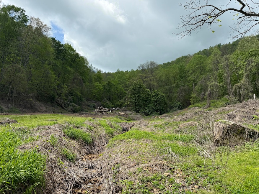
Dreaming of wide-open spaces and a slower pace of life? This 198-acre tract in Walker, KY, offers the perfect backdrop for a hunting camp, off-grid cabin, or private homestead. Selectively logged (16'' and larger) to maintain healthy forest growth, the land is rich with wildlife and natural beauty. Utilities are available at the road, giving you a head start if you want to build. Rolling hills, secluded woods, and endless adventure await. If you're looking for freedom and fresh air, this is your place! The stated acreage has been estimated by the (Local Property Valuation Administrator / boundary deed
description / Agriculture Soil Conservation Service). The estimate is not the result of a survey and
cannot be relied upon for accuracy. The property is selling by its boundary deed description.
Property Details
Property Type
- Other
Lot Details
- 198 Acre Lot
Property Views
- Woods
- Mountain
- Rural
Home Design
- Farm
Schools
- Dewitt Elementary School
- Knox Middle School
- Knox Central High School
Community Details
- Rural Subdivision
Listing and Financial Details
- Assessor Parcel Number 190-00-00-022.00
Map
Tax History
| Year | Tax Paid | Tax Assessment Tax Assessment Total Assessment is a certain percentage of the fair market value that is determined by local assessors to be the total taxable value of land and additions on the property. | Land | Improvement |
|---|---|---|---|---|
| 2025 | $119 | $7,950 | $7,950 | $0 |
| 2024 | $118 | $7,950 | $7,950 | $0 |
| 2023 | $121 | $7,950 | $0 | $0 |
| 2022 | $120 | $7,950 | $0 | $0 |
| 2021 | $120 | $7,950 | $0 | $0 |
| 2019 | $121 | $7,950 | $0 | $0 |
Property History
| Date | Event | Price | List to Sale | Price per Sq Ft |
|---|---|---|---|---|
| 11/01/2025 11/01/25 | Price Changed | $225,000 | 0.0% | -- |
| 11/01/2025 11/01/25 | For Sale | $225,000 | -5.3% | -- |
| 10/28/2025 10/28/25 | Off Market | $237,600 | -- | -- |
| 04/28/2025 04/28/25 | For Sale | $237,600 | -- | -- |
Purchase History
| Date | Type | Sale Price | Title Company |
|---|---|---|---|
| Deed | -- | -- |
Source: ImagineMLS (Bluegrass REALTORS®)
MLS Number: 25008595
APN: 190-00-00-022.00
Disclaimer: Certain information contained herein is derived from information provided by parties other than Homes.com. All information provided is deemed reliable, but is not guaranteed to be accurate and should be independently verified.
![]() The information is being provided by LBAR Multiple Listing Service. Information deemed reliable but not guaranteed. Information is provided for consumers' personal, non-commercial use, and may not be used for any purpose other than the identification of potential properties for purchase. Copyright 2026 LBAR Multiple Listing Service. All Rights Reserved.
The information is being provided by LBAR Multiple Listing Service. Information deemed reliable but not guaranteed. Information is provided for consumers' personal, non-commercial use, and may not be used for any purpose other than the identification of potential properties for purchase. Copyright 2026 LBAR Multiple Listing Service. All Rights Reserved.
- 106 Honda Ln
- 1610 Brices Creek Rd
- 51 Cherokee Mountain
- 7832 223 Hwy
- 9999 Hales Fork Rd
- 51 Houston Broughton Rd
- 195 Darby Branch Rd
- 0 Darby Branch Rd
- 435 Simms Fork Rd
- 100 Knot Hole Left Rd
- 6461 Kentucky 66
- 2683 Turkey Creek Rd
- 0 Hinkle Paynes Creek 215 253 Unit 25507987
- 100 Old Stinking Creek Rd
- 9999 May Fork Rd
- 9999 Turkey Creek Rd
- 00 Ky 66 Hendron Hill
- 0 Oscar Wagers Rd
- 11130
- 1047 Evergreen Rd

Ask me questions while you tour the home.