460 Federal Way Central Point, OR 97502
Estimated payment $3,324/month
Highlights
- City View
- Corner Lot
- No HOA
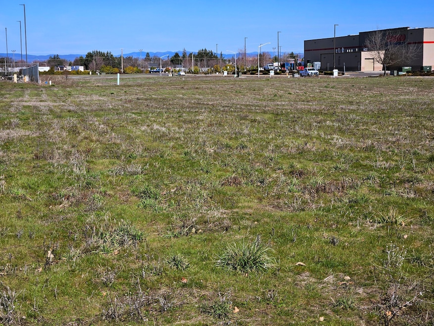
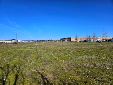
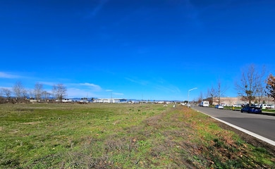
About This Lot
Adjacent to the new Amazon Distribution Center, and just down from Central Point' Costco location... this level M-1 zoned parcel allows for a multitude of developments. Utilities at the property. Logistically ideal, less than 5 miles to Interstate 5 and Rogue Valley International Airport, and all other major commercial developments. Ready for development!
Property Details
Property Type
- Land
Est. Annual Taxes
- $2,750
Lot Details
- 2.36 Acre Lot
- Corner Lot
- Level Lot
- Property is zoned M-1, M-1
Property Views
- City
- Mountain
- Territorial
Schools
- A C Houghton Elementary School
- Agnes Stewart Middle School
- Adrian High School
Utilities
- Phone Available
- Cable TV Available
Community Details
- No Home Owners Association
Listing and Financial Details
- Assessor Parcel Number 10988610
Map
Home Values in the Area
Average Home Value in this Area
Tax History
| Year | Tax Paid | Tax Assessment Tax Assessment Total Assessment is a certain percentage of the fair market value that is determined by local assessors to be the total taxable value of land and additions on the property. | Land | Improvement |
|---|---|---|---|---|
| 2025 | $2,750 | $164,370 | $164,370 | -- |
| 2024 | $2,750 | $159,590 | $159,590 | -- |
| 2023 | $2,666 | $154,950 | $154,950 | $0 |
| 2022 | $2,600 | $154,950 | $154,950 | $0 |
| 2021 | $2,531 | $150,440 | $150,440 | $0 |
| 2020 | $2,468 | $146,060 | $146,060 | $0 |
| 2019 | $2,407 | $137,680 | $137,680 | $0 |
| 2018 | $2,344 | $133,670 | $133,670 | $0 |
| 2017 | $2,298 | $133,670 | $133,670 | $0 |
| 2016 | $2,249 | $126,000 | $126,000 | $0 |
| 2015 | -- | $0 | $0 | $0 |
| 2014 | -- | $0 | $0 | $0 |
Property History
| Date | Event | Price | List to Sale | Price per Sq Ft |
|---|---|---|---|---|
| 04/29/2025 04/29/25 | Price Changed | $589,000 | -18.8% | -- |
| 02/15/2025 02/15/25 | Price Changed | $725,000 | -6.5% | -- |
| 04/04/2024 04/04/24 | Price Changed | $775,000 | -9.4% | -- |
| 12/29/2023 12/29/23 | Price Changed | $855,000 | -4.5% | -- |
| 03/10/2023 03/10/23 | For Sale | $895,000 | 0.0% | -- |
| 03/10/2023 03/10/23 | Price Changed | $895,000 | -5.8% | -- |
| 01/07/2023 01/07/23 | Pending | -- | -- | -- |
| 12/22/2022 12/22/22 | Price Changed | $950,000 | +19.5% | -- |
| 07/16/2018 07/16/18 | For Sale | $795,000 | -- | -- |
Source: Oregon Datashare
MLS Number: 102992034
APN: 10988610
Disclaimer: Certain information contained herein is derived from information provided by parties other than Homes.com. All information provided is deemed reliable, but is not guaranteed to be accurate and should be independently verified.
![]() © 2025 Oregon Datashare (KCAR | MLSCO | SOMLS). All rights reserved. The data relating to real estate for sale on this web site comes in part from the Internet Data Exchange Program of the Oregon Datashare. Real estate listings held by IDX Brokerage firms other than Ten-X are marked with the Internet Data Exchange logo or the Internet Data Exchange thumbnail logo and detailed information about them includes the name of the listing Brokers. Information provided is for consumers' personal, non-commercial use and may not be used for any purpose other than to identify prospective properties the viewer may be interested in purchasing. The consumer will not copy, retransmit nor redistribute any of the content from this website. Information provided is deemed reliable, but not guaranteed.
© 2025 Oregon Datashare (KCAR | MLSCO | SOMLS). All rights reserved. The data relating to real estate for sale on this web site comes in part from the Internet Data Exchange Program of the Oregon Datashare. Real estate listings held by IDX Brokerage firms other than Ten-X are marked with the Internet Data Exchange logo or the Internet Data Exchange thumbnail logo and detailed information about them includes the name of the listing Brokers. Information provided is for consumers' personal, non-commercial use and may not be used for any purpose other than to identify prospective properties the viewer may be interested in purchasing. The consumer will not copy, retransmit nor redistribute any of the content from this website. Information provided is deemed reliable, but not guaranteed.
- 4121 Table Rock Rd
- 1025 Fairfield Ave
- 4105 Table Rock Rd
- 4601 Biddle Rd Unit C
- 4251 Table Rock Rd
- 1840 E Pine St
- 4404 Biddle Rd
- 4286 Hamrick Rd
- 201 Orchardview Cir
- 921 Pittview Ave
- 811 O'Hare Pkwy
- 1600 E Pine St
- 230 Peninger Rd
- 851 Juanita Way
- 4399 Table Rock Rd
- 2770 Parkwood Village Ln
- 571 Briarwood Dr
- 959 Westrop Dr
- 301 Freeman Rd Unit 100
- 301 Freeman Rd Unit 23
- 700 N Haskell St
- 2190 Poplar Dr
- 1801 Poplar Dr
- 237 E McAndrews Rd
- 107 Applewood Dr
- 2030 Brookhurst St
- 645 Royal Ave
- 518 N Riverside Ave
- 406 W Main St
- 2642 W Main St
- 121 S Holly St
- 835 Overcup St
- 2654 N Foothill Rd
- 309 Laurel St
- 1661 S Columbus Ave
- 2532 Juanipero Way
- 556 G St
- 353 Dalton St
- 925 Olympic Ave
- 933 N Rose St
