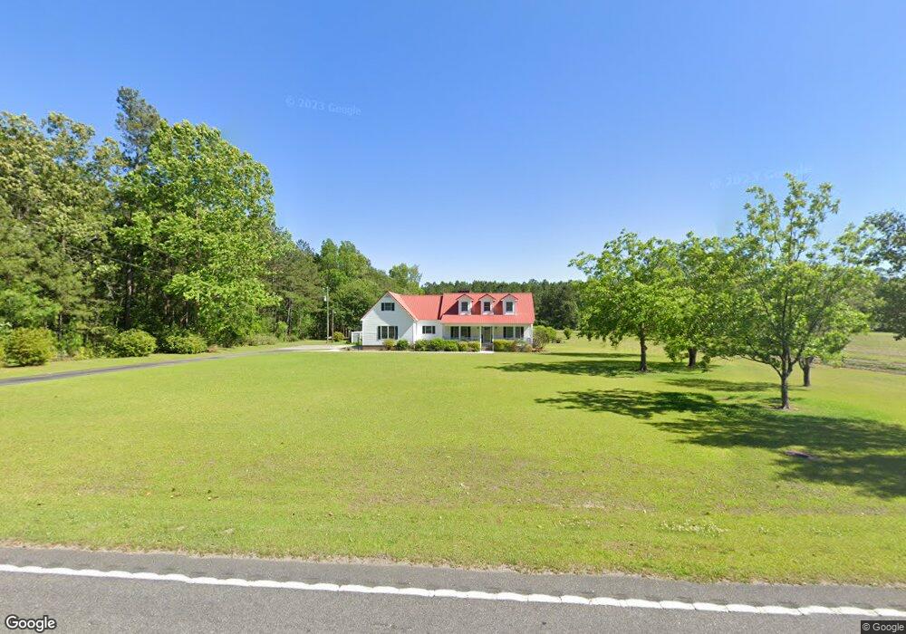
460 Horry Rd Conway, SC 29526
Estimated Value: $383,000 - $441,000
3
Beds
2
Baths
2,936
Sq Ft
$143/Sq Ft
Est. Value
About This Home
This home is located at 460 Horry Rd, Conway, SC 29526 and is currently estimated at $418,821, approximately $142 per square foot. 460 Horry Rd is a home located in Horry County with nearby schools including Midland Elementary School, Aynor Middle School, and Aynor High School.
Ownership History
Date
Name
Owned For
Owner Type
Purchase Details
Closed on
Mar 6, 2002
Sold by
Skipper Frances and Skipper Susan
Bought by
Chandler Kenneth M and Chandler Susan S
Current Estimated Value
Purchase Details
Closed on
Oct 26, 2001
Sold by
Chandler Susan Skipper
Bought by
Chandler Kenneth M and Chandler Susan S
Home Financials for this Owner
Home Financials are based on the most recent Mortgage that was taken out on this home.
Original Mortgage
$61,000
Interest Rate
6.67%
Mortgage Type
Purchase Money Mortgage
Create a Home Valuation Report for This Property
The Home Valuation Report is an in-depth analysis detailing your home's value as well as a comparison with similar homes in the area
Home Values in the Area
Average Home Value in this Area
Purchase History
| Date | Buyer | Sale Price | Title Company |
|---|---|---|---|
| Chandler Kenneth M | -- | -- | |
| Chandler Kenneth M | -- | -- |
Source: Public Records
Mortgage History
| Date | Status | Borrower | Loan Amount |
|---|---|---|---|
| Previous Owner | Chandler Kenneth M | $61,000 |
Source: Public Records
Tax History
| Year | Tax Paid | Tax Assessment Tax Assessment Total Assessment is a certain percentage of the fair market value that is determined by local assessors to be the total taxable value of land and additions on the property. | Land | Improvement |
|---|---|---|---|---|
| 2025 | -- | $0 | $0 | $0 |
| 2024 | -- | $15,672 | $2,576 | $13,096 |
| 2023 | $827 | $8,725 | $785 | $7,940 |
| 2021 | $914 | $10,539 | $1,175 | $9,364 |
| 2020 | $803 | $10,539 | $1,175 | $9,364 |
| 2019 | $803 | $10,539 | $1,175 | $9,364 |
| 2018 | $0 | $7,586 | $682 | $6,904 |
| 2017 | $0 | $7,586 | $682 | $6,904 |
| 2016 | $0 | $7,586 | $682 | $6,904 |
| 2015 | -- | $7,587 | $683 | $6,904 |
| 2014 | $655 | $7,587 | $683 | $6,904 |
Source: Public Records
Map
Nearby Homes
- 166 Westfield Cir Unit Lot 13
- 166 Westfield Cir
- 162 Westfield Cir Unit Lot 12
- 169 Westfield Cir Unit Lot 64 Bailey II 3 c
- 165 Westfield Cir Unit Lot 65 Courtland II-
- 165 Westfield Cir
- 504 Woodland Farms Cir
- 157 Westfield Cir Unit Lot 67 Bailey II
- 157 Westfield Cir
- 713 Horry Rd
- 315 Woodcross Ct
- 119 Westfield Cir Unit Lot 71 Odessa II
- 5.87 Acs Rabon Rd Unit Tract 4
- 115 Westfield Cir Unit Lot 72 Courtland II
- 115 Westfield Cir
- 323 Woodcross Ct
- 801 Rabon Rd Unit Lot 1 - Dogwood 4
- 111 Westfield Cir Unit Lot 73
- 811 Rabon Rd Unit Lot 2 - Rabon Rd
- 821 Rabon Rd Unit Lot 3 - Magnolia
- 375 Horry Rd
- 627 Horry Rd
- 635 Horry Rd
- 506 Rabon Rd
- 0 S Carolina 22
- 725 Horry Rd
- TBD S Carolina 22
- 873 Rabon Rd
- 237 Horry Rd
- 169 Westfield Cir Unit Lot 64
- 154 Westfield Cir Unit Lot 10
- 105 Clover Walk Dr
- 105 Clover Walk Dr Unit Lot 133- Cali B
- 139 Clover Walk Dr Unit Lot 126- Penwell A
- 109 Clover Walk Dr Unit Lot 132- Aria A
- 115 Clover Walk Dr Unit Lot 131- Wren B
- 123 Clover Walk Dr Unit Lot 130- Macon A
- 127 Clover Walk Dr Unit Lot 129- Kerry B
- 131 Clover Walk Dr Unit Lot 128 - Cali A
- 135 Clover Walk Dr Unit Lot 127- Aria A
Your Personal Tour Guide
Ask me questions while you tour the home.