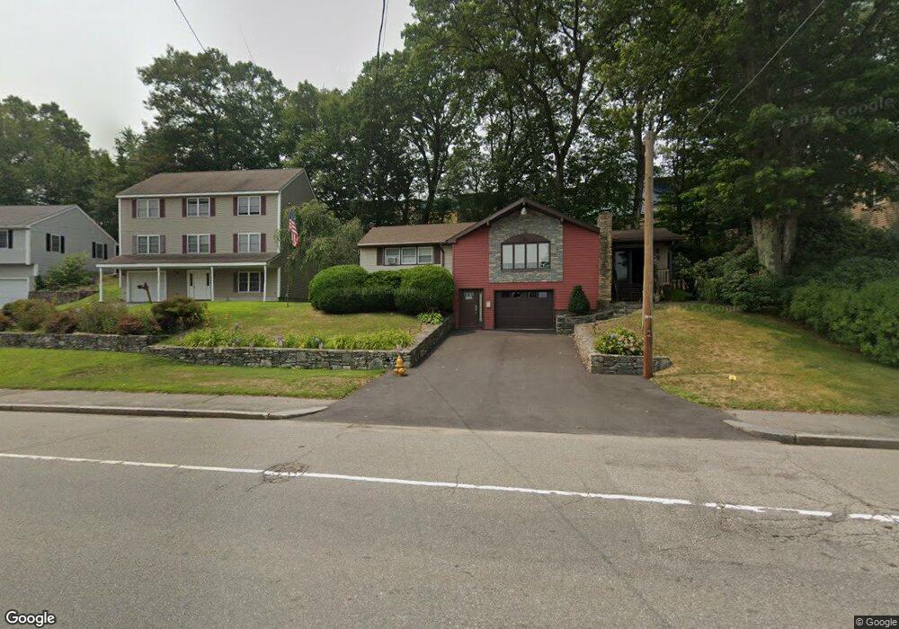
460 Lake Ave Worcester, MA 01604
Grafton Hill NeighborhoodEstimated Value: $408,000 - $441,385
3
Beds
1
Bath
1,332
Sq Ft
$316/Sq Ft
Est. Value
About This Home
This home is located at 460 Lake Ave, Worcester, MA 01604 and is currently estimated at $420,346, approximately $315 per square foot. 460 Lake Ave is a home located in Worcester County with nearby schools including Roosevelt Elementary School, Jacob Hiatt Magnet School, and Chandler Magnet.
Ownership History
Date
Name
Owned For
Owner Type
Purchase Details
Closed on
May 10, 2017
Sold by
Burrows Robert T and Burrows Laura R
Bought by
Burrows Robert T
Current Estimated Value
Create a Home Valuation Report for This Property
The Home Valuation Report is an in-depth analysis detailing your home's value as well as a comparison with similar homes in the area
Home Values in the Area
Average Home Value in this Area
Purchase History
| Date | Buyer | Sale Price | Title Company |
|---|---|---|---|
| Burrows Robert T | -- | -- |
Source: Public Records
Tax History Compared to Growth
Tax History
| Year | Tax Paid | Tax Assessment Tax Assessment Total Assessment is a certain percentage of the fair market value that is determined by local assessors to be the total taxable value of land and additions on the property. | Land | Improvement |
|---|---|---|---|---|
| 2025 | $5,037 | $381,900 | $118,200 | $263,700 |
| 2024 | $4,925 | $358,200 | $118,200 | $240,000 |
| 2023 | $4,851 | $338,300 | $102,800 | $235,500 |
| 2022 | $4,298 | $282,600 | $82,200 | $200,400 |
| 2021 | $4,260 | $261,700 | $65,800 | $195,900 |
| 2020 | $4,080 | $240,000 | $65,800 | $174,200 |
| 2019 | $3,830 | $212,800 | $59,200 | $153,600 |
| 2018 | $3,699 | $195,600 | $59,200 | $136,400 |
| 2017 | $3,759 | $195,600 | $59,200 | $136,400 |
| 2016 | $3,681 | $178,600 | $43,200 | $135,400 |
| 2015 | $3,585 | $178,600 | $43,200 | $135,400 |
| 2014 | $3,490 | $178,600 | $43,200 | $135,400 |
Source: Public Records
Map
Nearby Homes
- 3 Bay Edge Dr
- 7 Atlas St
- 14 Bay Edge Ln
- 23 Canna Dr
- 68 Bay View Dr
- 589 Sunderland Rd
- 31 Crane St
- 62 Edgemere Blvd
- 1199 Grafton St Unit 93
- 1195 Grafton St Unit 3
- 1201 Grafton St Unit 73
- 1203 Grafton St Unit 38
- 334 Bridle Path
- 11 Margin St
- 33 Lakeside Dr
- 340 Sunderland Rd Unit 23
- 270 Sunderland Rd Unit 37
- 270 Sunderland Rd Unit 77
- 270 Sunderland Rd Unit 67
- 15 Lakeside Dr