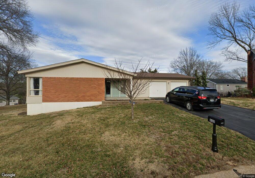
460 Tree Top Ln Saint Louis, MO 63122
Estimated Value: $471,384 - $603,000
3
Beds
3
Baths
1,692
Sq Ft
$311/Sq Ft
Est. Value
About This Home
This home is located at 460 Tree Top Ln, Saint Louis, MO 63122 and is currently estimated at $525,596, approximately $310 per square foot. 460 Tree Top Ln is a home located in St. Louis County with nearby schools including Westchester Elementary School, North Kirkwood Middle School, and Kirkwood Senior High School.
Ownership History
Date
Name
Owned For
Owner Type
Purchase Details
Closed on
Jun 29, 2016
Sold by
Collins William Randall
Bought by
Whatton Joseph G and Whatton Melissa A
Current Estimated Value
Home Financials for this Owner
Home Financials are based on the most recent Mortgage that was taken out on this home.
Original Mortgage
$160,000
Outstanding Balance
$127,632
Interest Rate
3.64%
Mortgage Type
New Conventional
Estimated Equity
$397,964
Create a Home Valuation Report for This Property
The Home Valuation Report is an in-depth analysis detailing your home's value as well as a comparison with similar homes in the area
Home Values in the Area
Average Home Value in this Area
Purchase History
| Date | Buyer | Sale Price | Title Company |
|---|---|---|---|
| Whatton Joseph G | $200,000 | Continental Title Holding Co |
Source: Public Records
Mortgage History
| Date | Status | Borrower | Loan Amount |
|---|---|---|---|
| Open | Whatton Joseph G | $160,000 |
Source: Public Records
Tax History Compared to Growth
Tax History
| Year | Tax Paid | Tax Assessment Tax Assessment Total Assessment is a certain percentage of the fair market value that is determined by local assessors to be the total taxable value of land and additions on the property. | Land | Improvement |
|---|---|---|---|---|
| 2025 | $4,132 | $86,170 | $64,070 | $22,100 |
| 2024 | $4,132 | $71,520 | $54,910 | $16,610 |
| 2023 | $4,068 | $71,520 | $54,910 | $16,610 |
| 2022 | $3,806 | $62,340 | $54,910 | $7,430 |
| 2021 | $3,765 | $65,150 | $54,910 | $10,240 |
| 2020 | $3,404 | $54,150 | $45,750 | $8,400 |
| 2019 | $3,421 | $54,150 | $45,750 | $8,400 |
| 2018 | $3,095 | $43,930 | $27,870 | $16,060 |
| 2017 | $3,103 | $43,930 | $27,870 | $16,060 |
| 2016 | $2,559 | $36,630 | $31,670 | $4,960 |
| 2015 | $2,552 | $36,630 | $31,670 | $4,960 |
| 2014 | $2,610 | $36,630 | $26,900 | $9,730 |
Source: Public Records
Map
Nearby Homes
- 467 Tree Top Ln
- 591-593 N Ballas Rd
- 2 Enclave Dr
- 4 Enclave Dr
- 2033 Woodland Knoll
- 9 Enclave Dr
- 2002 Woodland Knoll
- 11 Enclave Dr
- 12819 Huntercreek Rd
- 2025 Woodland Knoll
- 2005 Woodland Knoll
- 2145 Trailcrest Dr
- 698 Trailcrest Ct Unit 5
- 2029 Lily Ave
- 1800 W Adams Ave
- 2037 Trailcrest Ln Unit 7
- 1912 Windy Hill Rd
- 2000 Trailcrest Ln Unit 3
- 1612 Dougherty Ferry Rd
- 340 S Ballas Rd
- 459 Kassie View Ct
- 2140 Apple Hill Ln
- 453 Tree Top Ln
- 453 Kassie View Ct
- 454 Tree Top Ln
- 2130 Apple Hill Ln
- 465 Kassie View Ct
- 449 Tree Top Ln
- 450 Tree Top Ln
- 475 Tree Top Ln
- 452 Kassie View Ct
- 458 Kassie View Ct
- 2141 Apple Hill Ln
- 477 Kassie View Ct
- 440 Tree Top Ln
- 464 Kassie View Ct
- 445 Tree Top Ln
- 479 Tree Top Ln
- 2129 Apple Hill Ln
- 472 Tree Top Ln